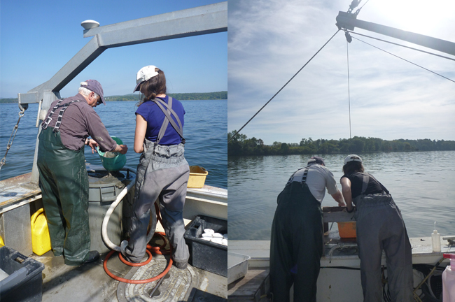
Robert Cerrato and Alison Flanagan, from Stony Brook University's School of Marine and Atmospheric Sciences sample fauna and sediment in Long Island's Haverstraw Bay. Credit: Maren Mitch
— By Chris Gonzales, Freelance Science Writer, New York Sea Grant
Scientists are using mathematical models to explore and understand undersea habitats, with the aim of conserving them.
Stony Brook, NY, August 17, 2023 - A group of researchers is thinking a lot about the conservation and management of undersea habitats, particularly those with soft bottoms: habitats with a mixture of gravel, sand, and mud. These habitats’ diversity of plant and animal life makes them particularly resource-rich, but vulnerable to disruption.
Resources, But Vulnerable
Experts expect there will almost certainly be some level of human activity taking place in these habitats to extract natural resources. Commercial fishing trawlers, for example, can kill many non-target animals in order to catch fish such as fluke, flounder, and haddock.
To help conserve these habitats, researchers have conducted “characterization studies” to learn more about what undersea habitats are like. They might include, for example, mudflats or seagrass meadows. They might be populated with worms, snails, clams, crabs, and amphipods, a shrimp-like animal.

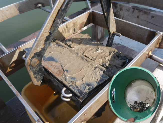
(At left) A faunal and sediment sample is collected in Haverstraw Bay using a van Veen grabber, a type of sampling equipment; (At right) A faunal sample after the process of sieving is complete. Credit: Alison Flanagan
As they make these studies, they often want to know what is happening at the community level, meaning they want to understand the relationships between the organisms living there. As they do this work, one particular question tends to recur: is it better to characterize habitats as drawn by discrete boundaries, or by varying gradients?
In a recent study, Alison Flanagan and Robert Cerrato of the School of Marine and Atmospheric Sciences (SoMAS) at Stony Brook University (SBU) and colleagues explored traditional characterization methods defined by boundaries, gradients, and variables. They considered variables such as water depth and sediment grain size, as well as sonar backscatter-mapped seabed features. They hoped to determine the most useful environmental variables for characterizing soft sea-bottom habitats, and then use these characterizations to inform management and conservation efforts.
“Benthic animal communities vary spatially in response to both the nonliving and living characteristics that all combine to form distinct habitats,” said Cerrato. “Nonliving characteristics include water depth, bottom substrate composition, and three-dimensional topography. Living characteristics include burrows, shells, and tubes. We evaluated how commonly collected sampling data can be used effectively as a management tool to identify benthic habitats and found that the most accurate approach always included maps created from sonar as a basis, since the strength of sound return off the seafloor reflected many of the important habitat attributes.”
Flanagan and her colleagues published a paper on the topic in the Journal of Environmental Management. This manuscript resulted from two projects — “Integrating Fish Trawl, Water Quality, and Benthic Mapping Data in the Peconic Estuary” and “Northern Harbors of Long Island”, and “Acoustic Mapping and Habitat Characterization in Haverstraw Bay” — with funding provided by the New York Department of Environmental Conservation, New York Sea Grant, and the Nature Conservancy’s Long Island Chapter.

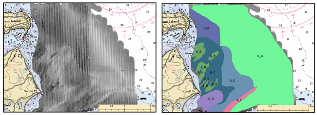
This example illustrates sonar-derived habitats, taken from Shelter Island, NY. The image on the left shows sonar data and the one on the right depicts the delineation of habitats. Credit: Alison Flanagan
Understanding the Very Bottom of the Sea
Benthic habitats are defined generally as areas of the seabed with distinct physical, chemical, and biotic characteristics. These types of communities are susceptible to natural and anthropogenic disturbances; thus these characteristics are excellent indicators of habitat quality.
One way to describe habitats on the community level is to identify sets of co-occurring species. However, in practice, in aquatic environments, such data are expensive to acquire. On the other hand, some variables (such as sediment grain size) may be easy to measure but might not be useful indicators of the type of aquatic life there. Including too many variables in a model may lead to overfitting, a situation where spurious conclusions might be drawn. Thus, the need to resolve the question of continuous or categorical variables (such as gradients or boundaries.)
Community-Habitat Relationships
The scientists set out to assess community-habitat relationships—between organisms in a community and their soft-sediment near-shore environments. They wanted to know which types of variables, and which variables, best explained those relationships.
They explored in five areas surrounding Long Island, New York: two within the Hudson River Estuary (Haverstraw Bay and one near the former Tappan Zee Bridge), one on Long Island’s North Shore (Huntington-Northport Harbor), and two areas within Long Island’s Peconic Bays Estuary (near Robins Island and near Shelter Island).
They collected high-resolution sonar data that could be converted to images of the bottom, as well as animal and sediment samples. They recorded water depth, and noted the surficial cover (for example, whether sand, seaweed, or shell.) They also counted and identified the types of living things they found. After setting up comparisons of existing, published habitat classification schemes, the scientists described the types of ocean floor characteristics they found using these existing schemes. Then the researchers used mathematical techniques to try to understand benthic community-habitat relationships.
Seeking Data Sets That Best Describe Reality
The researchers collected data about actual underwater, bottom habitats that could help other scientists design their studies. In particular, they can help them make decisions about form of the habitat (boundaries versus gradients, for example) and the complexity and cost of the variables they choose to measure (such as sediment size, water depth, and other variables.)
They also might help scientists decide which variables to prioritize—in effect, which ones have better explanatory power to determine the fauna found in underwater bottom habitats.
Which Variables Worked Best?
The scientists found that the variable form influenced the performance of the mathematical model they created, but often not substantially. Continuously varying sediment grain size in particular explained slightly more community variation than the fixed or simplified categorical sediment schemes often used (e.g., muddy sand, gravelly mud). Fixed categorical water depth almost always was less effective than continuous water depth measures. Finally, their “provinces” approach based on boundaries seen in sonar maps far outperformed the existing, published habitat classification schemes. Provinces are habitats at seascape scales, some as small as only a few square meters, but often larger; all are mappable using modern sonar imagery and thus easy to monitor.
Researchers see a need to ‘package’ a large amount of explanatory data in the fewest number of variables because collecting data using shipboard sampling is expensive. Sonar-based provinces might provide that avenue. Obvious candidates, they suggest, are additional metrics derived from sonar backscatter and bathymetry data.
Habitat Details Help Conservation
Ultimately, the researchers’ work helps us characterize undersea habitats more accurately and in more detail, which can lead to managers making better decisions for resource management and conservation.
References
Flanagan, A., et al. (2019). Quantitatively characterizing benthic community-habitat relationships in soft-sediment, nearshore environments to yield useful results for management. Journal of Environmental Management 249 109361. https://doi.org/10.1016/j.jenvman.2019.109361
More Info: New York Sea Grant
New York Sea Grant (NYSG), a cooperative program of Cornell University
and the State University of New York (SUNY), is one of 34 university-based
programs under the National Oceanic and Atmospheric Administration’s
National Sea Grant College Program.
Since 1971, NYSG has represented a statewide network of integrated
research, education and extension services promoting coastal community
economic vitality, environmental sustainability and citizen awareness
and understanding about the State’s marine and Great Lakes resources.
Through NYSG’s efforts, the combined talents of university scientists
and extension specialists help develop and transfer science-based
information to many coastal user groups—businesses and industries,
federal, state and local government decision-makers and agency managers,
educators, the media and the interested public.
The program maintains Great Lakes offices at Cornell University, SUNY
Buffalo, SUNY Oswego and the Wayne County Cooperative Extension office
in Newark. In the State's marine waters, NYSG has offices at Stony Brook
University and with Cornell Cooperative Extension of Nassau County on Long Island, Brooklyn College and Cornell Cooperative
Extension in NYC and Kingston in the Hudson Valley.
For updates on Sea Grant activities: www.nyseagrant.org has RSS, Facebook, Twitter, Instagram, and YouTube links. NYSG offers a free e-list sign up via www.nyseagrant.org/nycoastlines for its flagship publication, NY Coastlines/Currents, which is published quarterly.