Port Bay. Credit: Katie Graziano, New York Sea Grant.
— By Chris Gonzales, Freelance Science Writer, New York Sea Grant
Contacts:
Kathy Bunting-Howarth, NYSG's Associate Director, E: keb264@cornell.edu, P: 607-255-2832
Katie Graziano, NYSG Coastal Resilience Extension Specialist, E: kag247@cornell.edu, P: 718-951-5415
New York, NY, June 2, 2022 - Communities near the shore are thinking about—and developing—their resilience to floods, especially as these disruptions are happening more frequently due to climate change. Climate change is not only affecting ecosystems, it is disrupting the economies dependent on the shore as a resource for tourism, leisure, and community well-being. With more frequent flooding in coastal areas, there has been a growing interest in science- and nature-based solutions to help communities near the shore adapt.
A team of researchers recently published an article on the topic. They’ve been thinking about the concept of resilience, and how to define resilience in a way that it can be measured, assessed and promoted in design and policy. In the lingo of organizational communication, they call it “operationalizing” resilience.1
“With this publication, we are sharing what we learned from a multi-year process of developing a framework to define and monitor shoreline resilience,” said Katie Graziano, coastal resilience specialist with New York Sea Grant and one of the report’s coauthors. “The paper contributes to the conversation among academics, policymakers, and the public about what resilience means in practice.”
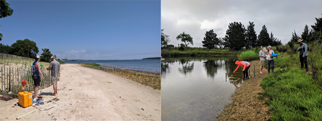
(At Left) In summer 2019, researchers piloted the shoreline monitoring protocols in diverse shorelines across New York State. Here, research fellows with the Science and Resilience Institute at Jamaica Bay collect shoreline resilience data from a pilot site at Widow's Hole, Long Island; (At Right) Researchers collect data at Cedar Creek Beach Inlet, Long Island. Credit: Katie Graziano, New York Sea Grant
Shoreline Resilience
When floodwaters rise repeatedly, many coastal communities install hard structural features, such as rock or concrete barriers at the shoreline.
These are often seen as the best and most reliable shoreline features. However, these seawalls, bulkheads, and revetments—collectively referred to as “shoreline armoring”—can have downsides: shoreline erosion, loss of biodiversity, and habitat degradation. Such barriers can give a false sense of security, leading people to underestimate the risks of flooding, surges, or damage.
Instead of relying on hardened infrastructure, New York State is encouraging coastal managers and landowners to consider greener alternatives, such as living shorelines, constructed marshes and sand dunes, and ecologically enhanced breakwaters and bulkheads. These natural and nature-based features (NNBF) are thought to provide similar risk-reduction benefits with fewer negative consequences. Yet despite a proliferation of these strategies in New York State, many questions remain about how well they can truly deliver risk reduction, ecological and community benefits. Prior to the development of the monitoring framework, there was no way to track these benefits.
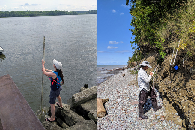
By recording the elevational profile of shoreline features over time, researchers can determine how the site is changing through erosion, accretion, or other coastal processes. This work is taking place (At Left) at the Coxsackie boat launch on the Hudson River and (At Right) at Port Bay in New York's Great Lakes region. Credit: Katie Graziano, New York Sea Grant
Creating a Statewide Monitoring Framework
In 2019, an interdisciplinary team led by the Science and Resilience Institute at Jamaica Bay set out to capture shoreline vulnerability and resilience across New York State. With support from New York State Department of State (NYSDOS) and New York State Energy Research and Development Authority (NYSERDA), they developed a monitoring framework to compare natural and nature-based shoreline features with conventional approaches to shoreline protection. Stakeholder working groups were assembled that represented four regions of the state with diverse shoreline characteristics: Hudson Valley, New York City, Long Island, and the Great Lakes.
The process required researchers, practitioners, and other stakeholders to assign a tangible meaning to the word ‘resilience,’ so that it could be measured through a suite of indicators. After the draft framework was developed, a subset of the project team reflected on this co-creative process and published their findings.
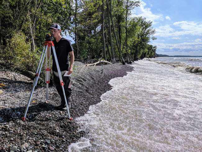
The pebbly shoreline and bluffs are characteristic of Port Bay in the Great Lakes. Credit: Katie Graziano, New York Sea Grant
Defining and Measuring Resilience
The researchers describe a process where the meaning of ‘resilience’ was co-created through multiple iterations, with stakeholder input and deliberation.
Careful shoreline monitoring provides the evidence base for shoreline managers and private landowners to make informed decisions about which approach will provide the most benefits. The framework is a step towards broader policy that could encourage natural and nature-based features, where appropriate.
“Climate change is forcing difficult decisions about how to manage shorelines and protect communities,” said Graziano. “As we collect more data with the monitoring framework, we will know more and more about the benefits of natural and nature-based shorelines, so that these decisions can be based on evidence and backed by science.”
References
1 Wijsman, K., D. S. N. Auyeung, P. Brashear, B. F. Branco, K. Graziano, P. M. Groffman, H. Cheng, and D. Corbett. 2021. Operationalizing resilience: co-creating a framework to monitor hard, natural, and nature-based shoreline features in New York State. Ecology and Society 26(3):10. https://doi.org/10.5751/ES-12182-260310
More Info: New York Sea Grant
New York Sea Grant (NYSG), a cooperative program of Cornell University
and the State University of New York (SUNY), is one of 34 university-based
programs under the National Oceanic and Atmospheric Administration’s
National Sea Grant College Program.
Since 1971, NYSG has represented a statewide network of integrated
research, education and extension services promoting coastal community
economic vitality, environmental sustainability and citizen awareness
and understanding about the State’s marine and Great Lakes resources.
Through NYSG’s efforts, the combined talents of university scientists
and extension specialists help develop and transfer science-based
information to many coastal user groups—businesses and industries,
federal, state and local government decision-makers and agency managers,
educators, the media and the interested public.
The program maintains Great Lakes offices at Cornell University, SUNY
Buffalo, SUNY Oswego and the Wayne County Cooperative Extension office
in Newark. In the State's marine waters, NYSG has offices at Stony Brook
University in Long Island, Brooklyn College and Cornell Cooperative
Extension in NYC and Kingston in the Hudson Valley.
For updates on Sea Grant activities: www.nyseagrant.org has RSS, Facebook, Twitter, Instagram, and YouTube links. NYSG offers a free e-list sign up via www.nyseagrant.org/nycoastlines for its flagship publication, NY Coastlines/Currents, which is published quarterly.