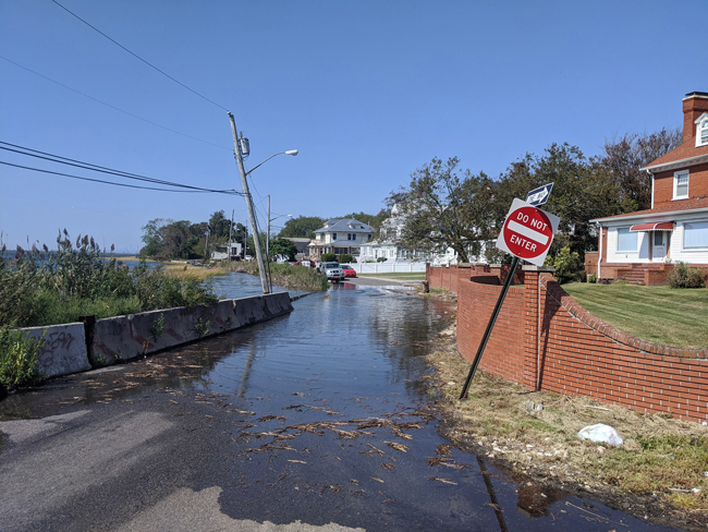
Credit: Community Flood Watch Project.
— Published by Center for NYC Neighborhoods for "Flood Help NY" e-newsletter
New York, NY, Novemver 1, 2020 - Even on days when there is no rain, there are some neighborhoods along New York City’s waterfront where streets often turn into rivers and homes are inundated by floodwaters. These communities are on the front lines of climate change where sea level rise is causing high tides to overflow barriers and rise up from storm drains.
One local effort that is trying to track this high-tide flooding in New York City is the Community Flood Watch Project. Through a network of volunteers, the project is documenting and reporting flooding in coastal communities. In the process, they are providing visual and data-based evidence to policy makers about the impact of rising sea levels. Originally based in Jamaica Bay, the project is expanding this year to City Island, Throggs Neck, and Locust Point in the Bronx; and Coney Island in Brooklyn.
“Ultimately, the hope is that with better hyperlocal data, coastal hazard notifications will be more accurate and there will be other ways to warn people of local flooding,” said Katie Graziano, a coastal resilience extension specialist with New York Sea Grant (NYSG). The project is a collaboration between NYSG, the Science and Resilience Institute at Jamaica Bay and the Mayor's Office of Resiliency.
High-tide flooding, also known as tidal or nuisance flooding, is expected to worsen in the coming years as sea levels rise. Such flooding can lead to costly property damage, degrade water quality, and even pose health risks to people who have to wade through the water.
The Community Flood Watch Project is actively seeking help from residents willing to volunteer their time to document flooding in their communities. Anyone interested should contact Graziano directly at kag247@cornell.edu.
To be notified of coastal flooding, be sure to sign up at NotifyNYC.
With NYC's flood risk rising, the FloodHelpNY.org quarterly e-newsletter gives you the tools to understand flood insurance and flood risk. Each quarter, we share tips, resources, and more. Subscribe or check out past issues.
More Info: New York Sea Grant and SRIatJB
The Science and Resilience Institute @ Jamaica Bay
(SRIJB) is a research center focused on enhancing environmental,
social, and economic resilience in communities of Jamaica Bay funded by
the Rockefeller Foundation and the City of New York.
New York Sea Grant (NYSG), a cooperative program of Cornell University
and the State University of New York (SUNY), is one of 34 university-based
programs under the National Oceanic and Atmospheric Administration’s
National Sea Grant College Program.
Since 1971, NYSG has represented a statewide network of integrated
research, education and extension services promoting coastal community
economic vitality, environmental sustainability and citizen awareness
and understanding about the State’s marine and Great Lakes resources.
Through NYSG’s efforts, the combined talents of university scientists
and extension specialists help develop and transfer science-based
information to many coastal user groups—businesses and industries,
federal, state and local government decision-makers and agency managers,
educators, the media and the interested public.
The program maintains Great Lakes offices at Cornell University, University at Buffalo, SUNY Oswego and the Wayne County Cooperative Extension office
in Newark. In the State's marine waters, NYSG has offices at Stony Brook
University in Long Island, Brooklyn College and Cornell Cooperative
Extension in NYC and Kingston in the Hudson Valley.
For updates on Sea Grant activities: www.nyseagrant.org has RSS, Facebook, Twitter, Instagram, and YouTube links. NYSG offers a free e-list sign up via www.nyseagrant.org/nycoastlines for its flagship publication, NY Coastlines/Currents, which is published quarterly. Our program also produces an occasional e-newsletter,"NOAA Sea Grant's Social Media Review," via its blog, www.nyseagrant.org/blog.