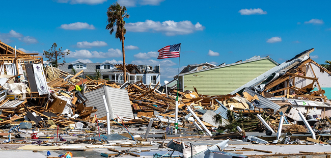
After Hurricane Michael made landfall in Mexico Beach, FL on Oct. 14, 2018. Credit: FEMA/K.C. Wilsey.
El Nino and warmer-than-average Atlantic help shape this season’s intensity
On Air: "NOAA's 2019 Atlantic Hurricane Outlook," May 23, 2019 ... If you don't see the player above, it's because you're using a
non-Flash device (eg, iPhone or iPad). You can download the mp3 file by clicking here (mp3). It may take a few minutes to download, so please be patient.
Contact:
Lauren Gaches, NOAA's National Centers for Environmental Prediction, E: lauren.gaches@noaa.gov, P: 202-740-8314
May 23, 2019 - The National Oceanic and Atmospheric Administration (NOAA)'s Climate Prediction Center is predicting that a near-normal Atlantic hurricane season is most likely this year. This outlook forecasts a 40% chance of a near-normal season, a 30% chance of an above-normal season and a 30% chance of a below-normal season. The hurricane season officially extends from June 1 to November 30.
For 2019, NOAA predicts a likely range of 9 to 15 named storms (winds of 39 mph or higher), of which 4 to 8 could become hurricanes (winds of 74 mph or higher), including 2 to 4 major hurricanes (category 3, 4 or 5; with winds of 111 mph or higher). NOAA provides these ranges with a 70% confidence. An average hurricane season produces 12 named storms, of which 6 become hurricanes, including 3 major hurricanes.
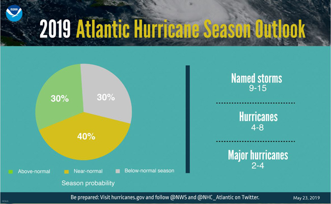
A graphic showing hurricane season probability and numbers of named storms. Credit: NOAA.
“With the 2019 hurricane season upon us, NOAA is leveraging cutting-edge tools to help secure Americans against the threat posed by hurricanes and tropical cyclones across both the Atlantic and Pacific,” said Secretary of Commerce Wilbur Ross. “Throughout hurricane season, dedicated NOAA staff will remain on alert for any danger to American lives and communities.”
This outlook reflects competing climate factors. The ongoing El Nino is expected to persist and suppress the intensity of the hurricane season. Countering El Nino is the expected combination of warmer-than-average sea-surface temperatures in the tropical Atlantic Ocean and Caribbean Sea, and an enhanced west African monsoon, both of which favor increased hurricane activity.
“New satellite data and other upgrades to products and services from NOAA enable a more Weather-Ready Nation by providing the public and decision makers with the information needed to take action before, during, and after a hurricane,” said Neil Jacobs, Ph.D., acting NOAA administrator.
2019 Atlantic Hurricane Season Outlook. Credit: NOAA.
The 2019 hurricane season marks the first time NOAA’s fleet of Earth-observing satellites includes three operational next-generation satellites. Unique and valuable data from these satellites feed the hurricane forecast models used by forecasters to help users make critical decisions days in advance.
NOAA’s National Weather Service is making a planned upgrade to its Global Forecast System (GFS) flagship weather model – often called the American model – early in the 2019 hurricane season. This marks the first major upgrade to the dynamical core of the model in almost 40 years and will improve tropical cyclone track and intensity forecasts. “NOAA is driving towards a community-based development program for future weather and climate modeling to deliver the very best forecasts, by leveraging new investments in research and working with the weather enterprise,” added Jacobs.
NOAA’s National Hurricane Center and NWS office in San Juan will expand the coastal storm surge watches and warnings in 2019 to include Puerto Rico and the U.S. Virgin Islands. In addition, NHC will display excessive rainfall outlooks on its website, providing greater visibility of one of the most dangerous inland threats from hurricanes.
Also, this season, NOAA’s Hurricane Hunter aircraft will collect higher-resolution data from upgraded onboard radar systems. These enhanced observations will be transmitted in near-real time to hurricane specialists at the National Hurricane Center, the Central Pacific Hurricane Center and forecasters at NWS Weather Forecast Offices.
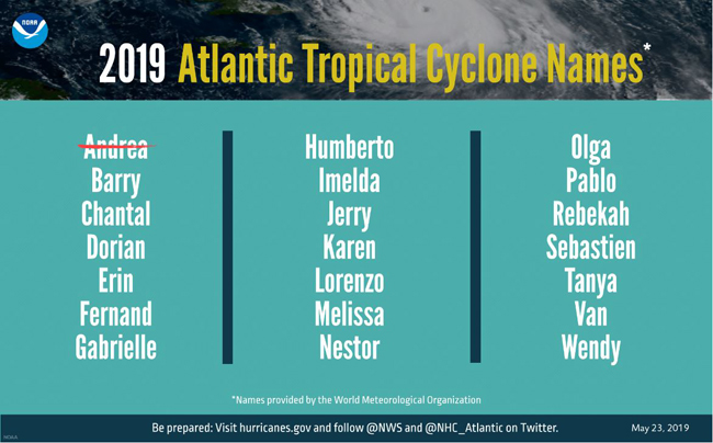
A graphic showing 2019 Atlantic tropical cyclone names selected by the World Meteorological Organization. Credit: NOAA.
In addition to the Atlantic hurricane season outlook, NOAA also issued seasonal hurricane outlooks for the eastern and central Pacific basins. A 70% chance of an above-normal season is predicted for both the eastern and central Pacific regions. The eastern Pacific outlook calls for a 70% probability of 15 to 22 named storms, of which 8 to 13 are expected to become hurricanes, including 4 to 8 major hurricanes. The central Pacific outlook calls for a 70% probability of 5 to 8 tropical cyclones, which includes tropical depressions, tropical storms, and hurricanes.
NOAA’s outlook is for overall seasonal activity and is not a landfall forecast. Hurricane preparedness is critically important for the 2019 hurricane season, just as it is every year. Visit the National Hurricane Center’s website at hurricanes.gov throughout the season to stay current on any watches and warnings.
“Preparing ahead of a disaster is the responsibility of all levels of government, the private sector, and the public," said Daniel Kaniewski, Ph.D., FEMA deputy administrator for resilience. “It only takes one event to devastate a community so now is the time to prepare. Do you have cash on hand? Do you have adequate insurance, including flood insurance? Does your family have communication and evacuation plans? Stay tuned to your local news and download the FEMA app to get alerts, and make sure you heed any warnings issued by local officials.”
NOAA’s Climate Prediction Center will update the 2019 Atlantic seasonal outlook in August just prior to the historical peak of the season.
More Info: NOAA Sea Grant’s Coastal Storm Awareness Program
VIDEO: NOAA Sea Grant documentary short on coastal storm awareness educates emergency managers, empowers coastal communities. Video also points to resources from NOAA's National Weather Service, the Federal Emergency Management Agency, NYC Office of Emergency Management and more. The 4-1/2 minute trailer for NOAA Sea Grant's Coastal Storm Awareness Program's 23-minute documentary, view-able on YouTube.
AUDIO: Theme Song: "Ask Yourself," Written and performed by Barbara A. Branca
Note: If you don't see the player above, it's because you're using a non-Flash device (eg, iPhone or iPad).
Superstorm Sandy in 2012 triggered a nationwide reassessment of coastal storm preparedness in the United States, including in the heavily impacted tri-state region (New Jersey, New York, Connecticut). Nearly 150 deaths and an estimated $50 billion in property damage were attributed to this storm.
Despite forecasts for the late October 2012 storm, too many coastal residents either failed to fully understand the severity of the storm and the dangerous conditions it would produce, or chose not to evacuate in spite of the serious risks of staying in their homes.
And so, the aim of the NOAA Sea Grant’s Coastal Storm Awareness Program (CSAP) was to help better understand through social science how people react to storm warnings and make the decision to stay or to go.
The suite of 10 studies, which was competitively funded at institutions from Yale University to Mississippi State University via Sandy Supplemental funds appropriated by Congress under the Disaster Relief Appropriations Act of 2013. This national competition drew on the decades of experience within NOAA and Sea Grant as well as the well-earned reputation for credibility and trust of the Sea Grant outreach communities in the tri-state region. By combining Sea Grant’s established relationship within local communities with current social science research, this effort helped to maximize awareness and understanding of the true severity of coastal hazards - even amongst hard to reach, isolated groups within communities.
Through research and outreach, both the quality of available information on coastal storm risks to humans, and understanding of factors influencing decisions by coastal residents in response to storm warnings was improved. Coastal storm communication professionals and emergency managers were the primary target audiences for CSAP outcomes. A Program Steering Committee of stakeholders helped guide the program and review the results.
Sea Grant staff and funded researchers shared results of the social science research at several key venues during this multi-year endeavor. Presentations were given at the Interagency Coordinating Committee on Hurricanes annual meeting in Fort Worth TX, at the National Hurricane Conference in New Orleans LA, at the NOAA National Hurricane Center in Miami, and at the Governor’s Hurricane Conference in West Palm Beach FL. Key audience members were local, state and federal officials involved in storm predictions, risk communication, storm preparation and emergency management and response. Numerous requests for additional information were met.
Research findings and related outreach efforts are detailed in a May 2016 comprehensive summary, "NOAA Sea Grant Coastal Storm Awareness Program Comes Ashore." Additionally, you can find a visual wrap-up of this research suite via a 23-minute short documentary and its companion four-and-a-half minute video trailer, which were also released that spring. Both point to resources from NOAA's National Weather Service, the Federal Emergency Management Agency, NYC Office of Emergency Management and more.
For more on NOAA Sea Grant's Coastal Storm Awareness Program see www.nyseagrant.org/csap. NYSG also offers additional resources on severe storms at www.nyseagrant.org/hurricane and www.nyseagrant.org/superstormsandy.
More Info: New York Sea Grant
New York Sea Grant (NYSG), a cooperative program of Cornell University
and the State University of New York (SUNY), is one of 33 university-based
programs under the National Oceanic and Atmospheric Administration’s
National Sea Grant College Program.
Since 1971, NYSG has represented a statewide network of integrated
research, education and extension services promoting coastal community
economic vitality, environmental sustainability and citizen awareness
and understanding about the State’s marine and Great Lakes resources.
Through NYSG’s efforts, the combined talents of university scientists
and extension specialists help develop and transfer science-based
information to many coastal user groups—businesses and industries,
federal, state and local government decision-makers and agency managers,
educators, the media and the interested public.
The program maintains Great Lakes offices at Cornell University, SUNY
Buffalo, SUNY Oswego and the Wayne County Cooperative Extension office
in Newark. In the State's marine waters, NYSG has offices at Stony Brook
University in Long Island, Brooklyn College and Cornell Cooperative
Extension in NYC and Kingston in the Hudson Valley.
For updates on Sea Grant activities: www.nyseagrant.org has RSS, Facebook, Twitter, and YouTube links. NYSG offers a free e-list sign up via www.nyseagrant.org/nycoastlines for its flagship publication, NY Coastlines/Currents, which is published quarterly. Our program also produces an occasional e-newsletter,"NOAA Sea Grant's Social Media Review," via its blog, www.nyseagrant.org/blog.