New York, NY, November 1, 2013 - As seen in the video below from NOAA Ocean Today, for seven days in the
Fall of 2012, Hurricane Sandy pounded the Caribbean and U.S. East Coast
with punishing rain, wind, and waves. As the storm approached landfall,
the National Hurricane Center renamed the hurricane "Post-Tropical
Cyclone Sandy." But to those whose lives were devastated—it will
always be remembered as Superstorm Sandy.
What happened in the atmosphere that caused this monstrous storm to form? Summer and winter weather conditions collided with extreme forces. The primary difference between a tropical cyclone, also called a hurricane, and a wintertime cyclone is the energy source. Tropical cyclones extract heat from the ocean and grow by releasing that heat in the atmosphere near the storm center. Wintertime storms, on the other hand, get most of their energy from temperature contrasts in the atmosphere, and this energy usually gets distributed over larger areas.
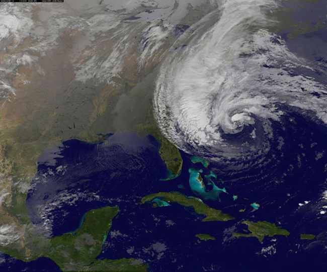
Sandy started out as a classic hurricane, getting energy from the warm waters of the Caribbean and moving northward along the Gulf Stream. Sandy then took a sharp left turn into the New Jersey and New York coasts and collided with a winter-like storm system.
As Sandy's energy source transitioned from the warm ocean water to the atmosphere it morphed into a wintertime cyclone and dramatically increased in size. High winds extended 1,000 miles across bringing record-breaking storm surges to coastal areas and blizzard conditions to the mountains. Tunnels turned into rivers and parking lots into ponds. Residents returned to find their belongings floating in pools of water in their homes and yards. Cars were pushed around like toys and mountains of sands filled the streets. Power outages lasted for days, weeks, and in some places for months. One neighborhood even burned to the ground.
Initial calculations for damages were $50 billion. As cities and towns rebuild that number continues to rise. Sandy is a heartbreaking reminder that the end of summer isn't the end of hurricane season. Hurricane season runs from June 1 to November 30 with the peak of the season from mid-August to late October. Put together an emergency plan and supply kit now, so you are prepared for extreme weather no matter when it strikes.
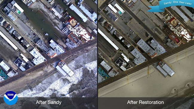
BEFORE AND AFTER SANDY: Use the NOAA National Ocean Service sliding image gallery to compare aerial images captured of Sandy's destruction over the Eastern Seaboard with NEW images of restored areas one year later. [About the composite NOAA image above: Views of Music Pier at Ocean City, New Jersey]
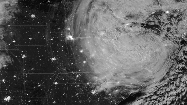
As NOAA/NASA
captured via NOAA's Satellite and Information Service Environmental
Visualization Lab, this photo shows Sandy after landfall in the
early morning of October 30, 2012 (3:35 am EDT), as imaged by the VIIRS
instrument's day/night band onboard the NOAA/NASA Suomi-NPP satellite.
This band collects information from the ambient light radiated into
space from human settlement and activities and also captures reflected
moonlight from cloud structures. The full moon, which enhanced the storm
surge that inundated New York City and Atlantic City, NJ because of
tidal forces, lit up the cloud tops of the storm in great detail.
Sandy, one year later: Sandy was the 18th named storm of the 2012 Atlantic hurricane season, in which there were 19 named storms. Sandy was one of two major hurricanes of the season. Here are some more Sandy stats:
- First NHC Advisory: Oct. 22; 11 a.m. EDT; Tropical Depression 18 forms over the southwestern Caribbean
- Peak Intensity: 115mph near eastern Cuba
- Landfall: 7:30 p.m. EDT Oct. 29 near Brigantine, N.J. (Post-tropical cyclone with maximum sustained winds of 80 mph)
Read more from the official NWS service assessment on Sandy.
More Superstorm Sandy news from NOAA:
Beachfront Q&A: Talking about dunes, development, storms, and sea level rise (Climate.gov, October 28, 2013)
After Sandy: Rebuilding & Recovery
National Ocean Service Post-Sandy Support Overview
After Sandy: Changes and Choices (Climate.gov, October 28, 2013)
After Sandy: Facing the Future (Climate.gov, October 29, 2013)
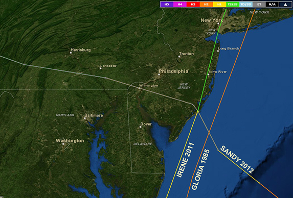
NOAA Coastal Services Center: Historical Hurricane Tracks
Three historical hurricane tracks. Damaging winds from Sandy spanned more than 800 miles in diameter, driving a massive storm surge that brought record flood devastation to parts of New York, New Jersey, and Connecticut.
Seeing where hurricanes have hit and how often is one of the best ways to bring home a powerful hurricane preparedness message. Last October as Post-Tropical Cyclone Sandy barreled up the East Coast, more than 14,000 visitors in five days used NOAA’s Historical Hurricane Tracks Web site to learn about past storms that followed similar paths.
This site lets users insert their zip code and see a map that contains more than 150 years of Atlantic hurricane tracking data. It also links to the life histories of U.S. tropical cyclones since 1958, contains global hurricane data as far back as 1842, and offers insight on the increasing numbers of U.S. citizens and infrastructure at risk from big storms. Consider a link from your site to Historical Hurricane Tracks so your constituents can better understand local hurricane history and work toward greater resilience.
A Year After Sandy: Sea Grant and Coastal Storm Awareness
The Sea Grant network has been actively engaged in both the short term and long term recovery for those impacted by Sandy
Tuesday, October 29, 2013
By Kathryn MacDonald, National Sea Grant Office
It has been a year since Sandy pounded the east coast, and the wounds are still healing. With over $62 billion in damages and 140 deaths, this storm shook the very foundation of the coastal communities that live and work in impacted areas.
Since the storm, the NOAA Sea Grant network has been actively engaged in the recovery effort, both long and short term. Many Sea Grant extension agents helped with initial damage assessments immediately after the storm. In New York, Sea Grant assisted federal, state and local officials in assessing the breach in Fire Island, a barrier island fronting a portion of mainland Long Island containing 13,000 homes collectively valued at 10 billion dollars. Sea Grant-funded researchers are studying the resilience benefits of natural coastline protection, like the work by New Jersey Sea Grant on the identification of best possible ways to nourish beaches and dunes. Sea Grant is helping local communities develop long term solutions for climate change adaptation. After the record storm surges during Sandy, Connecticut Sea Grant brought together University of Connecticut scientists, and state energy and environmental protection agencies to create a center that will leverage academic expertise in research and outreach to address the most pressing and specific needs of coastal communities in the state.
The National Sea Grant Office (NSGO) was able to connect Sea Grant programs experienced with inundation like Louisiana, Hawaii, Mississippi-Alabama, and Texas to the north-east programs experiencing severe hurricane damage for the first time. The NSGO was also able to deliver rapid-response research funds to New York, New Jersey, and Connecticut Sea Grant programs. To address more long-term issues, a collaborative partnership between FEMA Recovery Directorate and Sea Grant is underway to facilitate a connection between FEMA regional recovery coordinators and respective Sea Grant Extension agents and specialists.
Recently, to improve public understanding and awareness of natural hazards and associated risks, NOAA Sea Grant awarded a $1.8M grant to New Jersey Sea Grant, New York Sea Grant and Connecticut Sea Grant to support the Coastal Storm Awareness Program. This grant will fund social science research to enhance the Nation’s ability to respond to disasters by closely examining how people react to storm warnings. Sea Grant is helping to focus efforts on communicating these hazards to the public in practical and useful ways. Currently Sea Grant works with local communities to reach their citizens, both virtually and face-to-face, so that people both receive and understand threats. The results of this research and outreach will lead to a more aware public, able to make informed decisions with clear understanding of the risks and consequences of their choice.