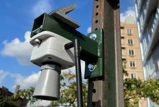
A FloodNet sensor measures flood water in realtime in Soundview, Bronx. It uses a solar panel for power and transmits data wirelessly. Credit: FloodNet
NOTE: FloodNet makes information about potentially dangerous flooding and frequent nuisance flooding easily accessible to the people that need it. A collaboration with contributions from the Science and Resilience Institute at Jamaica Bay, Brooklyn College, CUNY's Advanced Science Research Center (at the Graduate Center), NYU Tandon School of Engineering, NYC Mayor's Office of Climate & Environmental Justice, NYC Office of Technology and Innovation, and New York Sea Grant.
— Filed by Rosemary Misdary for The Gothamist, a non-profit newsroom powered by WNYC FM
New York, NY, February 16, 2023 - A program that tracks flooding across the city in real time is expanding, allowing more New Yorkers to see water depths and flood risks as rain is pouring down.
FloodNet, a collaborative project developed in autumn 2020 by multiple NYC colleges, currently consists of 31 sensors deployed in areas prone to severe floods, such as the Gowanus Canal.
But a recent city grant of $7.2 million will increase its network of citywide sensors to more than 500 over the next five years, beginning this month with installations on Staten Island.
“We're striving to make data as accessible to the average New Yorker as possible, meaning that they can access and understand the data,” said Brett Branco, a professor of earth and environmental sciences at Brooklyn College and a lead scientist for FloodNet. “That can be useful for them in terms of responding to a flooding event in real time as it happens.”
The sensors attach to a signpost, about 10 feet up, and work by sending an ultrasonic pulse to the ground. Those sound waves bounce off whatever surfaces are below and then travel back up to the sensor, measuring how much water is on the ground. These energy-efficient units are also solar-powered and transmit data wirelessly.
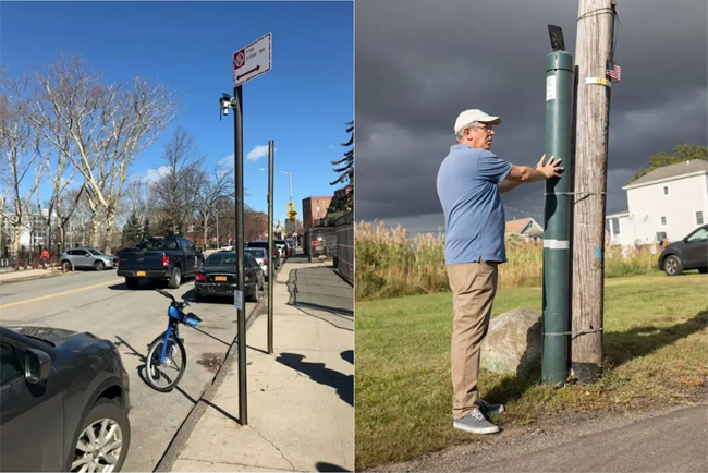
(at left) A FloodNet sensor is attached to a sign post in Red Hook, Brooklyn, about 10 feet above the ground. There are currently 31 of these devices deployed citywide. Over the next five years, the number will increase to over 500; (at right) Brett Branco, a professor of earth and environmental sciences at Brooklyn College and the CUNY Graduate Center, is one of the lead researchers on FloodNet. He is pictured in Hamilton Beach in Queens next to a sensor enclosed in a PVC pipe strapped to a pole. Credit: FloodNet
FloodNet’s dashboard, launched a year after Hurricane Ida, displays all the data collected by its open-source sensors, allowing residents to monitor and respond to a flood as it is happening. Residents can see the recorded depths and receive alerts as well as historical flooding data.
For example, the Beach 84th Street sensor, located in Rockaway Beach, Queens, shows both flash flood information and tide data. The area experiences regular flooding during full moon tides, when the water depth typically reaches 6 inches, according to sensor data.
This data gathering contributes to the growing community engagement that is part of the project’s scientific work. Researchers interact with residents on how to improve the project, and local stakeholders request sensors for certain spots while also offering suggestions for making the data more user-friendly.
Branco and scientists from the Advanced Science Research Center at the CUNY Graduate Center and NYU's Tandon School of Engineering work in partnership with the NYC Mayor’s Office of Climate and Environmental Justice and the Office of Technology and Innovation. The team said it is creating a real-time interface with the data to help benefit both residents and decision-makers. This system could potentially alert residents about which roads are impassable as they seek safety during a storm, or aid city agencies in determining where mitigation projects could be most effective.
“I had heard a lot of anecdotal evidence of there being street-level flooding monthly due to high tides, but we do have some locations where it'll be like six or seven days in a row,” said Andrea Silverman, an assistant professor at NYU's Tandon School of Engineering and a lead scientist for FloodNet. “Every 12 to 24 hours there's a flood that coincides with that tide, and you really need to see the data to fully understand the extent of which this is happening now.”
FloodNet began as a collaboration between Branco and Silverman. They installed their first sensor in October 2020 on the corner of Hoyt and Fifth streets in Gowanus, Brooklyn.
“There are so many city agencies and other agencies like the MTA, where flooding has effects right down to the point that people die,” said Klaus Jacob, a geophysicist and climate expert at Columbia University’s Climate School who isn't involved with the project. “The data set could help city agencies to set priorities where infrastructure money needs to be spent to fix the flooding problem.”
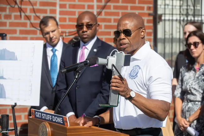
Mayor Eric Adams holds a FloodNet sensor at a press conference in September 2022 where he outlined various city initiatives related to flooding. The city is funding FloodNet's expansion with $7.2 million. Credit: FloodNet
FloodNet is also valuable to the research community. Weather models and forecasting tools that identify future flooding can be checked for accuracy against the FloodNet dataset and improved for precision.
As the FloodNet team expands its network citywide, it also hopes to collect more information beyond the basic depth of water on a street. Silverman said she wants to know more about flooding rates at a storm's onset, local drainage rates, and the duration of an event.
“We'll be able to, over time, help provide information on these dynamic changes and how they actually impact people,” Silverman said. “If there's a flood developing, looking at one of the [real-time] data sets, we can understand how we issue the right warnings to people in advance or do we need to issue other warnings now.”
More Info: New York Sea Grant
New York Sea Grant (NYSG), a cooperative program of Cornell University
and the State University of New York (SUNY), is one of 34 university-based
programs under the National Oceanic and Atmospheric Administration’s
National Sea Grant College Program.
Since 1971, NYSG has represented a statewide network of integrated
research, education and extension services promoting coastal community
economic vitality, environmental sustainability and citizen awareness
and understanding about the State’s marine and Great Lakes resources.
Through NYSG’s efforts, the combined talents of university scientists
and extension specialists help develop and transfer science-based
information to many coastal user groups—businesses and industries,
federal, state and local government decision-makers and agency managers,
educators, the media and the interested public.
The program maintains Great Lakes offices at Cornell University, SUNY
Buffalo, SUNY Oswego and the Wayne County Cooperative Extension office
in Newark. In the State's marine waters, NYSG has offices at Stony Brook
University in Long Island, Brooklyn College and Cornell Cooperative
Extension in NYC and Kingston in the Hudson Valley.
For updates on Sea Grant activities: www.nyseagrant.org has RSS, Facebook, Twitter, Instagram, and YouTube links. NYSG offers a free e-list sign up via www.nyseagrant.org/nycoastlines for its flagship publication, NY Coastlines/Currents, which is published quarterly.