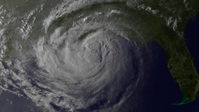
Stony Brook, NY, August 29, 2012 - Hurricane Isaac, which made a second landfall near Port Fourchon, LA earlier today and is moving inland over southeast Louisiana, has many concerned about storm surge and flooding.
The hurricane comes about seven years after Katrina hit the United States and a year since Irene.
Last August, New York Sea Grant (NYSG)-funded researchers from Stony Brook University's (SBU) School of Marine and Atmospheric Sciences (SOMAS) helped track Hurricane Irene. Their data was well documented by
New York Times' environmental/climate-change reporter Andrew Revkin, who kept his Web visitors apprised of this force of nature via his interactive blog, Dot Earth (see
NYSG's related news item). Some of these researchers, including Stony Brook University (SBU) Oceanography professor and storm surge expert Malcom Bowman, were also featured in the late-August 2012
Associated Press story, "Year after Irene, New Yorkers Ponder Sea Barriers" (
pdf). Bowman is also a member of
The Stony Brook Storm Surge Research Group, which has been funded principally by NYSG since 2002 to work on storm surge science, coastal defense systems and policy issues related to regional protection of New York City and Long Island.
As for Katrina, educators who took part in the New York State Marine Education Association (NYSMEA) / NYSG-hosted wetlands trip in and around New Orleans both this and last February learned all about "Restoration Efforts in the City with a Ring Around It," as detailed in NYSG Web Content Manager Paul C. Focazio's February 2012 NYSMEA blog entry (
click here).
For the latest updates on Hurricane Isaac, check out
NOAA (NOAA) National Weather Service's National Hurricane Center Web site or on Twitter at
www.twitter.com/NHC_Atlantic or
www.twitter.com/usNWSgov. NOAA and Sea Grant reminds that when it comes to severe weather, "Stay informed, stay alert & follow instructions from your local emergency management officials."
Additional related resources can be found via NYSG at
www.nyseagrant.org/hurricane. One of the featured links is to NOAA's Web site on coastal flooding, which is by far the leading killer during a hurricane. For more on this site, check out the
related news item.

With sunlight fading, the National Oceanic and Atmospheric Administration's (NOAA) GOES-13 satellite captured this visible image of Hurricane Isaac in the evening of Tuesday, August 28, 2012 as the storm made landfall in Plaquemines Parish, which is about 95 miles east of New Orleans. Photo courtesy of NOAA