— By Chris Gonzales, Freelance Science Writer, New York Sea Grant
Stony Brook, NY, December 7, 2018 - When Superstorm Sandy hit Long Island in late October 2012, among the many effects was a 500-foot wide breach opened in Fire Island, a barrier on the southern edge of the island that for thousands of years has separated a series of bays from the ocean. A year after funding a rapid response study on the topic, New York Sea Grant released a blog post that included a photo journal series documenting the work of the project’s principal investigator, Charlie Flagg, based at Stony Brook University (SBU) School of Marine and Atmospheric Sciences (SoMAS).
Flagg discovered an unexpected side effect of Sandy: increased circulation and flushing, which has led to better water quality, and reduced incidence of harmful algal blooms (HABs).
In fact, three breaches were opened by the superstorm. Two were closed immediately by the Army Corps of Engineers; officials decided to leave the one in Fire Island Park’s wilderness area to evolve on its own. Thus, the storm effectively had changed the number of inlets to the Atlantic Ocean from four to five. Called by some a “breach,” and by others, the “new inlet,” it has remained open since Sandy, becoming an area of interest for anglers, environmentalists, and scientists alike.
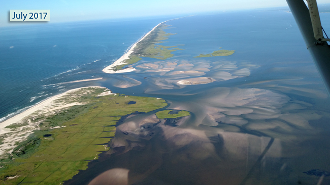
Aerial view of new inlet, Great South Bay, July 16, 2017. Credit: Charles Flagg / Stony Brook University.
As detailed in “Superstorm Sandy: One Year Later - Long Island Breach,” a NYSG news item that accompanied the December 2013 blog post, one account reports anglers’ increased catches of fluke, striped bass, and bluefish. Seals and small sharks visit. Clammers report “firmer clams,” a positive change.
This inlet opens into the Great South Bay (GSB), the area behind the barrier island, which in the 1970s supplied three-quarters of the clams sold in the United States. Since Sandy, according to measurements taken by Flagg and his investigative team, the tidally-driven volume of water changeover in central GSB has quadrupled.
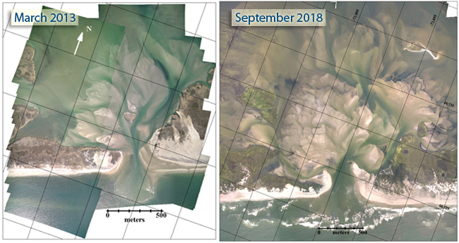
(At left) Aerial mosaic from March 2013, about five months after the breach was formed. (At right) Aerial mosaic from September 2018, nearly six years after the breach was formed. Credit: Charles Flagg / Stony Brook University.
“This [breach] event happened against a backdrop of several years of data collection by Stony Brook University on water properties and water levels in Great South Bay,” said Flagg, who has led research on the topic both during and since NYSG’s initial support. Thanks to additional funding from the National Park Service and the New York Department of Environmental Conservation, Flagg’s findings were recently published in the scientific journal Estuaries and Coasts1.
“These data were used to quantify the immediate impact of the breach,” said Flagg. “A combination of aerial surveys, water property and water level observations, bathymetric surveys of the breach, and numerical circulation modeling show how the Bay has responded to the increased exchange between the ocean and Bay.”
Their results also show that the new inlet produced a significant decrease in flushing time—approximately a 35% reduction under summer wind conditions and a 20% reduction in winter.
Water quality changes
Declining water quality in the GSB has been a problem since the 1950s, with a high incidence of HABs due to nitrogen loading. These algal outbreaks have threatened shellfish production.
“Over several months the higher salinity waters in Bellport Bay have mixed with waters of central Great South Bay so that salinities everywhere are now higher than before the breach,” Flagg said.
The breach has allowed more ocean water into and out of the bay more rapidly, leading to increased salinity, greater water clarity, and a decrease in nitrogen and chlorophyll levels.
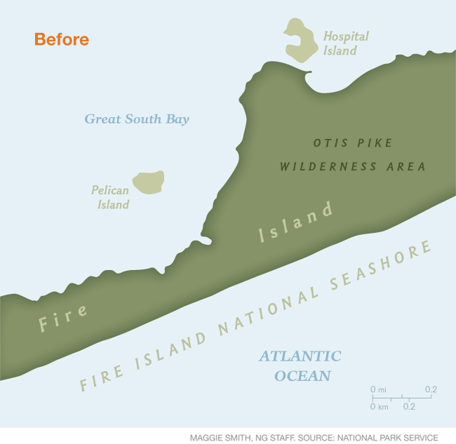
Nowhere did October 2012's Sandy move things around more dramatically than on Fire Island, a barrier beach between the Atlantic Ocean and Long Island's Great South Bay. Sandy blasted three breaches in the barrier islands along the south shore. Two of them were immediately filled in by the Army Corps of Engineers, as mandated by a Breach Contingency Plan put in place in 1997 by New York State's Department of Environmental Conservation (NYSDEC).
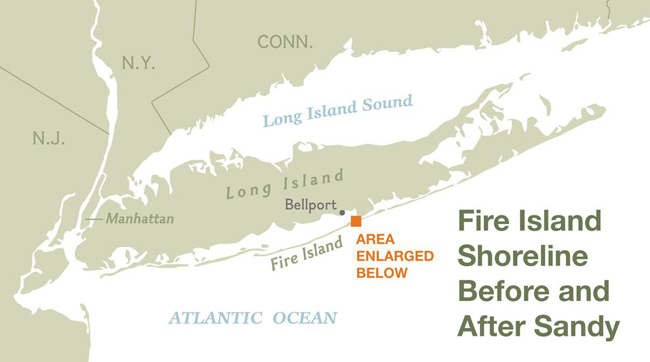
The third breach, across from the town of Bellport, was within the federally protected Fire Island National Seashore. Responding to the pleas of south shore residents, who blamed the breach for increased flooding in the months following the storm, politicians from Suffolk County Executive Steven Ballone to U.S. Senator Chuck Schumer called for that inlet to be closed as well. Credit: National Geographic.
A before, after, and one-year later animation image of Fire Island and the breach that Superstorm Sandy created. Credit: National Geographic.
Motivating questions
Flagg and his fellow researchers wanted to understand how these changes in hydrology and bathymetry (loosely speaking, the dynamics of the water and the depth of the sea floor) affected specifically the circulation and flushing time of the new inlet. They used a three-dimensional numerical circulation model called FVCOM (Finite Volume Coastal Ocean Model) to examine the impact of the breach on the tides, storm surge and current within the south shore bays.
Using the numerical model, they looked at renewal rate and exposure time—the latter variable similar to residence time or how long water remains in an enclosed area—using a passive tracer.
The upshot, and looking ahead
Long-term water quality shows a decrease in nitrogen levels at stations along GSB.
Flagg and colleagues believe the breach will likely fill in and close in the future. The closure would likely lead to a reversal of the positive changes in flushing time and water quality.
“Water level observations from before and after Sandy, together with circulation model results show that there have been minor alterations to the tidal regime within the Bay and that the threat of additional storm surge as result of the breach are also minor,” said Flagg. “Overall, the breach has been less of a threat than some initially feared while the increased exchange of Bay and ocean waters has substantially improved the water quality.”
References
1 Hinrichs, C., Flagg, C., & Wilson, R. (2018). Great South Bay After Sandy: Changes in Circulation and Flushing due to New Inlet. Estuaries and Coasts.
More Info: New York Sea Grant
New York Sea Grant (NYSG), a cooperative program of Cornell University
and the State University of New York (SUNY), is one of 33 university-based
programs under the National Oceanic and Atmospheric Administration’s
National Sea Grant College Program.
Since 1971, NYSG has represented a statewide network of integrated
research, education and extension services promoting coastal community
economic vitality, environmental sustainability and citizen awareness
and understanding about the State’s marine and Great Lakes resources.
Through NYSG’s efforts, the combined talents of university scientists
and extension specialists help develop and transfer science-based
information to many coastal user groups—businesses and industries,
federal, state and local government decision-makers and agency managers,
educators, the media and the interested public.
The program maintains Great Lakes offices at Cornell University, SUNY
Buffalo, SUNY Oswego and the Wayne County Cooperative Extension office
in Newark. In the State's marine waters, NYSG has offices at Stony Brook
University in Long Island, Brooklyn College and Cornell Cooperative
Extension in NYC and Kingston in the Hudson Valley.
For updates on Sea Grant activities: www.nyseagrant.org has RSS, Facebook, Twitter, and YouTube links. NYSG offers a free e-list sign up via www.nyseagrant.org/nycoastlines for its flagship publication, NY Coastlines/Currents, which is published quarterly. Our program also produces an occasional e-newsletter,"NOAA Sea Grant's Social Media Review," via its blog, www.nyseagrant.org/blog.