Credit: Unsplash
— By Dana Kochnower, assistant director for Land Use and Buildings at the NYC Mayor's Office of Resiliency, for Apolitical (Original article appears here)
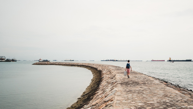
Brooklyn, NY, March 24, 2020 - In Jamaica Bay, life has always revolved around water. But now the water is rising
In New York City’s Jamaica Bay area, life has always ebbed and flowed with the tides.
The area is notable for its wetlands and waterfowl, and while longtime residents say they’re used to living with the water, the difference now, they say, is how often the tide exceeds the normal high tide.
For one resident, the difference between a normal high tide and a new moon tide is going out to dinner to wait for the water in front of their home to recede. For another, it means moving the car to higher ground and texting the neighbours to do the same.
According to the National Oceanic and Atmospheric Administration (NOAA), the Northeast Atlantic is seeing increased flooding from high tides; 2018 set a new record and the trend is projected to continue as sea levels rise.
To understand what this means for the hundreds of thousands of people living in New York City’s lowest-lying neighbourhoods and the infrastructure that supports them, resiliency planners are using crowdsourcing to track high-tide flooding events and the social impacts of living with water.
The canary in the coalmine
Long before Hurricane Sandy’s 13-foot storm surge devastated New York in 2012, the City had been preparing for climate change.
For more than a decade, the City has worked with the New York City Panel on Climate Change (NPCC), an independent body of researchers who develop local observations and projections for climate hazards. Their most recent report included a new model projecting Mean Monthly High Water (MMHW) for the rest of the century. These are the higher-than-high tides that happen during the full and new moons, roughly twice a month.
The NPCC model showed what planners had been hearing anecdotally from residents in Jamaica Bay: during the highest tides, either combined with storms or on sunny days, there is flooding in the streets. With sea level rise projections of two and a half feet over the next few decades, these neighbourhoods are the first indicators – like the canary in the coalmine – of the chronic impacts of sea level rise in coastal New York City.
To build resiliency in the short-term and plan for adapting these communities and others for the future, the City needed more detailed local information about current conditions.
Seeing the bigger picture
While the City’s 3-1-1 information and complaint system does collect reports on street flooding, the form used by residents to report flooding doesn’t currently categorize the source of the water beyond asking whether it is raining.
Searching for opportunities to compliment 3-1-1 data, planners pursued other sources. In 2018, the City joined the Connected Citizens Program, a data sharing exchange for governments with the Google traffic app, Waze. Drivers alert each other to hazards such as street flooding through the app; planners have access to the data feed which can then be analyzed and mapped. While useful for part of the story, like tracking a storm across the city, the Waze reports were concentrated on the highways, not the local streets seeing the most frequent flooding.
Around the same time, Helen Cheng, the New York Sea Grant Coastal Extension Specialist with the Science and Resilience Institute at Jamaica Bay (SRIJB) was holding a series of climate education forums and hearing similar stories about tidal flooding which led to the launch of the Flood Watch Community Science Program. Built largely on Cheng’s relationships with community leaders in Jamaica Bay who had been sharing flood information and photos on Facebook, Flood Watch calls on residents to document tidal events in their neighbourhoods.
Cheng designed and implemented a protocol for the program that includes training residents to record the date, time, location and duration of the flooding along with a photo. By overlaying the three data sources, 3-1-1 complaints, Waze reports and Flood Watch reports, the City has been able to build a more comprehensive picture of sunny day tidal flooding.
Once up and running, Flood Watch caught on with three neighbourhoods, generating more than 255 reports in the first year. The program is run by a small team and is primarily funded through staff time, especially Cheng’s, who travels to community meetings in the evenings and on weekends to build and maintain a level of trust with community leaders. Cheng says keeping participants active is a challenge, and works to create tools like a map of the flood reports posted on the Science and Resilience Institute website.
The City and SRIJB have used the data to collaborate with the National Weather Service to improve language on coastal flood alerts and refine local weather service thresholds for minor, moderate and major flooding.
Fighting climate change, neighbourhood by neighbourhood
In the fall of 2019, the City brought on a graduate fellow studying social work to conduct social science research with participants.
Through interviews about their experiences living with this type of flooding, the study captures the disruptions to daily life and the ways residents are already adapting to sea level rise, including strengthening neighbourhood-wide networks. Based on the success of the Jamaica Bay pilot, the City also secured funding from a FEMA Cooperating Technical Partnership grant to recruit new communities.
The goal for Flood Watch is more than data collection. It is strengthening partnerships between scientists, communities and government where local knowledge is valued along with academic research. That’s where the SRIJB is most critical. In her role as Coastal Extension Specialist, Cheng is working to foster dialogue through clear scientific information and communication about how a City like New York can adapt to climate change, coastal neighbourhood by neighbourhood.
Flood Watch participants are building a repository of knowledge that will contribute to planning for sea level rise across the City’s 520 miles (836 kilometres) of coastline, including how these "canaries" are already adapting. Resident reports will help determine where technologies like flood sensors are installed. These sensors provide consistent data for city infrastructure agencies that operate and maintain roads, sewers and waste collection. Similarly, stories about living with water will inform more targeted weather alerts and emergency services notifications and will help pinpoint the economic impacts of disruption to daily commuting routines and local commerce.
By building trusted relationships and enabling collaboration between the public sector, researchers and coastal communities, Flood Watch is helping address complex problems with bottom up solutions.
About the Author: Dana Kochnower, assistant director for land use and buildings at the NYC Mayor's Office of Resiliency. This article was selected by C40 Cities as a winner in Apolitical's 2020 American Public Servant Writing Competition.
More Info: New York Sea Grant and SRIatJB
The Science and Resilience Institute @ Jamaica Bay
(SRIJB) is a research center focused on enhancing environmental,
social, and economic resilience in communities of Jamaica Bay funded by
the Rockefeller Foundation and the City of New York.
New York Sea Grant (NYSG), a cooperative program of Cornell University
and the State University of New York (SUNY), is one of 34 university-based
programs under the National Oceanic and Atmospheric Administration’s
National Sea Grant College Program.
Since 1971, NYSG has represented a statewide network of integrated
research, education and extension services promoting coastal community
economic vitality, environmental sustainability and citizen awareness
and understanding about the State’s marine and Great Lakes resources.
Through NYSG’s efforts, the combined talents of university scientists
and extension specialists help develop and transfer science-based
information to many coastal user groups—businesses and industries,
federal, state and local government decision-makers and agency managers,
educators, the media and the interested public.
The program maintains Great Lakes offices at Cornell University, SUNY
Buffalo, SUNY Oswego and the Wayne County Cooperative Extension office
in Newark. In the State's marine waters, NYSG has offices at Stony Brook
University in Long Island, Brooklyn College and Cornell Cooperative
Extension in NYC and Kingston in the Hudson Valley.
For updates on Sea Grant activities: www.nyseagrant.org has RSS, Facebook, Twitter, and YouTube links. NYSG offers a free e-list sign up via www.nyseagrant.org/nycoastlines for its flagship publication, NY Coastlines/Currents, which is published quarterly. Our program also produces an occasional e-newsletter,"NOAA Sea Grant's Social Media Review," via its blog, www.nyseagrant.org/blog.