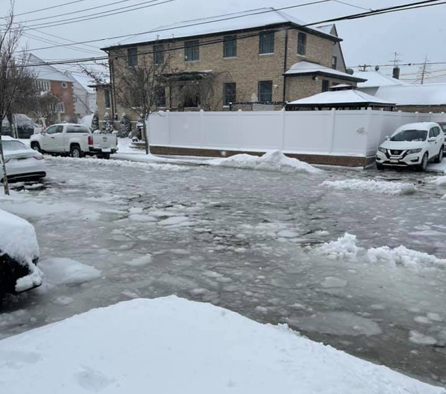
Flooding from high tide (9:53 am) and snow during Nor’easter on December 17, 2020 - 98th St, btw 161st/162nd Avenues, Howard Beach, Queens, NY at 11:05 am. Credit: Maureen Lowery via NYC Community Flood Watch Project on Facebook.
Coastal communities face more frequent weather disruptions (eg floods), which, according to a recent report, will increase w/ sea level rise
— Published by Patch.com, Brooklyn
Note: As the sea levels rise all around NYC, you can learn about the NYC Community Flood Watch Project and connect with other "flood watchers" - On February 23rd (2 pm) and 25th (6:30 pm), join New York Sea Grant and The Science and Resilience Institute at Jamaica Bay for their "Flood Watch" Virtual Workshop. Sign up at www.srijb.org/jbfloodwatch.
Brooklyn, NY, February 17, 2021 - New York Sea Grant (NYSG), together with partners the Science and Resilience Institute at Jamaica Bay (SRI@JB), New York City Emergency Management, the New York City Mayor’s Office of Resiliency (MOR), and the U.S. Department of Agriculture’s Forest Service (USFS) New York City Urban Field Station, have released a new research brief, “Flood Watch Social Impacts,” describing the social impacts associated with “sunny day” floods, minor but persistent floods that can present challenges for residents in low-lying coastal areas. Furthermore, the report describes actions residents have been taking to adapt to the flooding.
Also called “nuisance” or “high-tide” flooding, these events typically happen without media attention. But scientists know they are happening more frequently due to sea level rise. This new research shows some of the specific quality-of-life effects that are ongoing today with periodic flooding during normal weather.
“The Community Flood Watch Project is a collaboration between resident volunteers, scientists and government agencies, all with a shared goal to increase resilience to flooding in the face of rising sea levels,” said Katie Graziano, a coastal extension specialist with New York Sea Grant.
For the past two years, Flood Watch has been collecting photos of flooding from community residents. New York City officials wanted to know more about the social impacts of the flooding, pictures and video of which had been circulating on social media. Flood Watch program partners teamed with USFS to learn more, leading to the social impacts study and the research brief.
Such flooding, it turns out, can block people’s access to subway stations, delay the mail, and disrupt city services. The floods have also damaged property and made people late for work or routine medical appointments. Residents have been responding by, for example, changing travel routes or times, moving their car, moving items out of the basement, or even buying a high-clearance vehicle such as an SUV. Some residents even mentioned moving out of the neighborhood.
The authors of the report are USFS’s Lindsay Campbell and Erika Svendsen; MOR’s Dana Kochnower and Phoebe Wapnitsky; NYSG’s Helen Cheng; and NYSG’s Kathy Bunting-Howarth.
The 11-page report (pdf) draws on the first-person accounts of flood disruptions newly collected from Flood Watch participants. The research team began collecting reports in a systematic way, recording details—the date, time, depth, duration, and source of flooding. They also gathered photographs and video.
The Flood Watch program started in 2018 in the Jamaica Bay area and has gathered 377 reports from individuals about neighborhood, sunny-day flooding.
“Community flood reports allow researchers to improve flood forecasts and alerts, empower residents to communicate flood impacts on their daily lives, and give decision-makers a better understanding of current issues and potential interventions,” said Graziano.
“Catastrophic flooding associated with large storms like hurricanes gain great attention, but people’s lives are often disrupted by the smaller, more frequent street-level floods that accompany high tides and high-intensity rain events,” said Kathy Bunting-Howarth, NYSG’s Associate Director. “This pilot study sought to test a protocol to learn more about people’s lived experience with flooding where it occurs, how it impacts them, and how they adapt their behaviors to mitigate risk.”
Flood Watch is currently active in Hamilton Beach, Howard Beach, and in the eastern side of the Rockaways, in Queens, New York. It is now expanding into Coney Island, the Bronx, and any neighborhood where residents are willing to volunteer their time to send in flood reports.
High-tide flooding is happening with increasing frequency due to climate change. A higher relative sea level, land subsidence (sinking), and the loss of natural coastal barriers are each contributing factors.
FloodWatch (and the related report) was most recently featured in NYSG’s Winter 2021 newsletter, NY Coastlines, for which e-subscriptions can be made at www.nyseagrant.org/nycoastlines.
Other highlights from the e-newsletter:
(a) NYSG's Biennial Research Call for 2022-2023, the pre-proposal deadline for which is 4:30 PM on Thursday, February 25, 2021. Approximately $120,000 per year per project will be provided to support, in total, about 6-7 projects (each anticipated to begin February 1, 2022);
(b) Launch of "Community Science Long Island," a new monthly educational webinar series for 2021 being hosted by Seatuck Environmental Association, Long Island Sound Study, and NYSG with support from the New York State Department of State's South Shore Estuary Reserve and Peconic Estuary Partnership;
(c) U.S. Congress' reauthorization of Sea Grant, a nationally-networked program of the National Oceanic and Atmospheric Administration, through 2025. The Act, signed into law this past December, serves as a guiding framework upon which Sea Grant operates and serves America's coastal and Great Lakes communities.
More Info: New York Sea Grant
New York Sea Grant (NYSG), a cooperative program of Cornell University
and the State University of New York (SUNY), is one of 34 university-based
programs under the National Oceanic and Atmospheric Administration’s
National Sea Grant College Program.
Since 1971, NYSG has represented a statewide network of integrated
research, education and extension services promoting coastal community
economic vitality, environmental sustainability and citizen awareness
and understanding about the State’s marine and Great Lakes resources.
Through NYSG’s efforts, the combined talents of university scientists
and extension specialists help develop and transfer science-based
information to many coastal user groups—businesses and industries,
federal, state and local government decision-makers and agency managers,
educators, the media and the interested public.
The program maintains Great Lakes offices at Cornell University, University at Buffalo, SUNY Oswego and the Wayne County Cooperative Extension office
in Newark. In the State's marine waters, NYSG has offices at Stony Brook
University in Long Island, Brooklyn College and Cornell Cooperative
Extension in NYC and Elmsford and Kingston in the Hudson Valley.
For updates on Sea Grant activities: www.nyseagrant.org has RSS, Facebook, Twitter, Instagram, and YouTube links. NYSG offers a free e-list sign up via www.nyseagrant.org/nycoastlines for its flagship publication, NY Coastlines/Currents, which is published quarterly. Our program also produces an occasional e-newsletter, "NOAA Sea Grant's Social Media Review," via its blog, www.nyseagrant.org/blog.