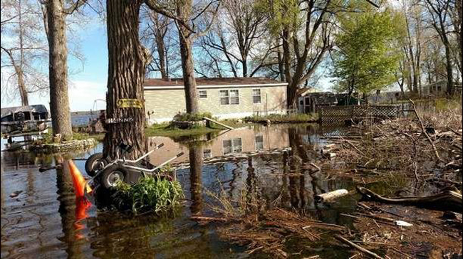
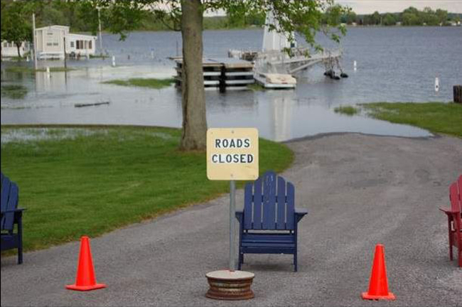
A photo of flooding in the town of Brownville in 2017, included as a part of the Coastal Flooding Survey Project assessing high water levels on Lake Ontario. Credit: Coastal Flooding Survey Project, Cornell University and New York Sea Grant.
Contact:
Mary Austerman, Great Lakes Coastal Community Development Specialist, New York Sea Grant, P: 315-331-8415, E:mp357@cornell.edu
Newark, NY, June 27, 2018 - The 2017 high water level impact survey - funded by New York Sea Grant and developed and implemented by Dr. Scott Steinschneider and Dr. Richard Stedman at Cornell University - provided an opportunity to document the parcel-level impacts of the event on waterfront properties, identify areas most vulnerable to future flooding, and verify existing flood-risk modeling.
Survey data results and photos from the summary of 490 validated high water survey responses by Lake Ontario property owners in New York as well as public testimony and resources related to the 2017 Lake Ontario record high water level event can be found in NYSG's April 2018 news item, "High Water Level Survey Results and Resources."
For more on the "High Water Impact Surveys for Lake Ontario Property Owners" project visit www.nyseagrant.org/waterlevel2017.
Below are several media stories filed in late April — late May 2018, after the project survey results were released ...
No flooding this year, but Lake Ontario is still high
Filed by: David Sommerstein, Reporter/Asst. News Director, North Country Public Radio
If you don't see the player above, it's because you're using a
non-Flash device (eg, iPhone or iPad). You can download the mp3 file by clicking here (mp3). It may take a few minutes to download, so please be patient.
Canton, NY, May 25, 2018 - With the spring melt behind us, Lake Ontario and the St. Lawrence River are not likely to see a repeat of last summer's high water levels.
But a year after heavy rains and snowmelt pushed the huge bodies of water to record levels, flooding shoreline from Buffalo to Ogdensburg, regulators are still trying to help return things to normal. Researchers are already using last year's data to pinpoint the areas most vulnerable to flooding in the future.
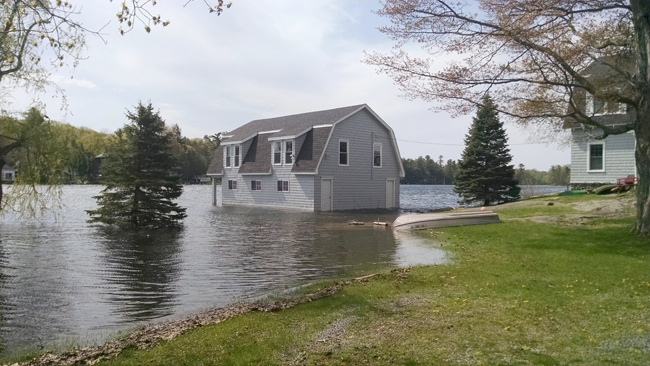
Owatonna Island in Chippewa Bay last summer. Credit: Allan Menkel/NCPR.
Lake Ontario remains higher than average
Lake Ontario is almost two feet lower than it was at this time last year. But it’s still ten inches above the long-term average. That means regulators are still trying to help the massive bodies of water return to normal. Tony David is a member of the International Lake Ontario St. Lawrence River Board, which manages the water levels. "There’s still a lot of water left on Lake Ontario," David says. "Water regulation has been doing everything that it can to get as much water off the lake and through the St. Lawrence River."
There’s only so much the Board can do to keep the lake or river stable. Nature is the biggest factor. David says the big problem now is lots of water coming from the upper Great Lakes. "Lake Superior is about a foot above long-term average. Michigan and Huron about a foot and a half. Lake Erie is about two feet above long-term average."
The only way the Board can lower Lake Ontario is to push more water through the Moses-Saunders hydropower dam on the St. Lawrence near Massena. The board was funneling as much water as it could downriver all winter. It eased back a bit during the spring melt to prevent flooding downriver in Montreal. But now David says the dam is passing as much water downriver as possible again. "Actually right now we are at the maximum outflow for safe navigation on the St. Lawrence Seaway," David says, to prevent dangerously fast currents for big ocean-going ships.
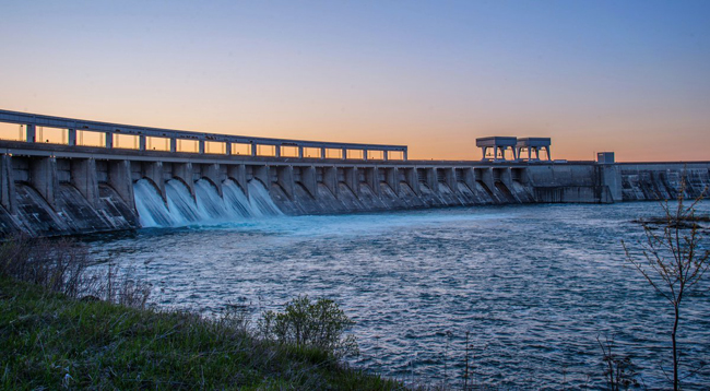
The Moses-Saunders power dam near Massena, NY. It's the only tool regulators have to manage water on lake Ontario and the St. Lawrence. Nature does the rest. Credit: New York Power Authority.
Shoreline property owners still skittish
Even though a repeat of last summer’s high water seems unlikely at this point, shoreline homeowners from Buffalo to Massena remain nervous.
"People are still a little bit sensitive to the issues that were present last year," says Mary Austerman with New York Sea Grant, who is part of a team trying to extract lessons from last summer’s record high water. She conducted a survey of 500 people along Lake Ontario and the St. Lawrence River. It found 60% had flooding in the main building on their property. More than 80% didn’t have flood insurance. New York State spent $95 million to help those people and to aid municipalities along the shoreline in recovery.
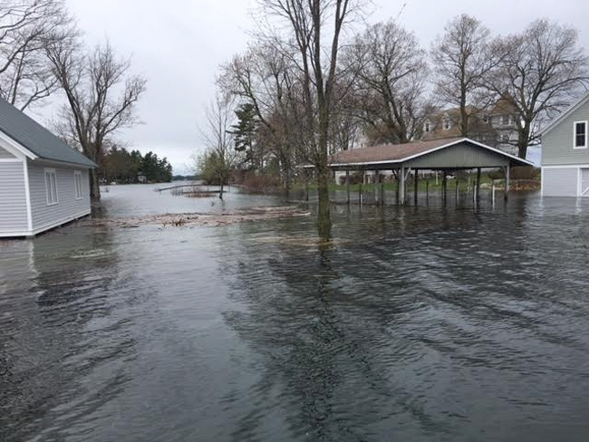
Boathouses, docks, and guest cottages like this one on Oak Point in Hammond, took on water all along Lake Ontario and the St. Lawrence River. Researchers are gathering data to pinpoint areas susceptible to flooding in the future. Credit: Katy Thomas.
The team also documented the high water from the air, publishing a series of photographs from overflights conducted last summer.
Finding the most sensitive spots for future flooding
Austerman says researchers at Cornell University are now using that survey and other data to find areas most susceptible to flooding going forward. "With the changing weather patterns that we’ve been experiencing, we don’t know when it’s going to happen again," Austerman says, "but it could happen again."
Austerman says the research will help identify places most likely to experience the worst storm surges and highest waves. That way, she says, communities and property owners can invest in better barriers or erosion protection for the next time the water gets too high.
Researchers work on analyzing last year’s flooding to make better predictions
Filed by: Abraham Kenmore, Watertown Daily Times
Watertown, NY, Saturday, May 13, 2018 - Following last year’s flooding along Lake Ontario and the St. Lawrence River, Scott Steinschneider of Cornell University began working with Mary Austerman of the New York Sea Grant to survey just how much damage had been done.
Now, Mr. Steinschneider, assistant professor of biological and environmental engineering, has received a $237,431 grant to turn the surveys of lakefront communities into a parcel-by-parcel tool for local residents and municipalities to examine the likelihood of flooding.
“It was Mary’s idea to put together a survey ... and just get some baseline understanding of what is happening,” Mr. Steinschneider said. He said all the information yields a “really good” picture of what occured on the ground.
From May to August of last year, the two collected surveys from people whose property had been flooded, including photographs of the areas that were inundated — completely submerged in water. This data allows Mr. Steinschneider and his fellow researchers to compare their models for the likelihood of flooding under particular conditions to what happened in 2017. By comparing their model and the actual flooding documented by residents, they can refine the model to let lakefront communities plan.
“We can build this model, but we want to make sure we’re making good predictions,” Mr. Steinschneider said. “The hope is that it’s a tool that can be directly useful for local municipalities for flood risk planning.”
The grant will allow Mr. Steinschneider to hire a graduate student and pay for the time researchers will put in to create this tool.
For now the modeling will focus just on areas at risk of inundation, without looking at the more complicated issue of erosion caused by flooding. Even so, the ability to map areas likely to be inundated can help with everything from replanning to emergency response.
To help determine the most useful kinds of information to collect, the researchers are forming a group of 18 property owners, municipal officials and county officials from lakeside communities.
Case study sites are being considered around Sodus Bay, Pulaski or Sandy Creek and Rochester or Greece, although Mr. Steinschneider hopes eventually the tool will be able to help communities all along Lake Ontario. Separately from this research, a version of the survey was modified and distributed by the International Joint Commission along the Canadian side of the lake.
“We’re excited to get it going and see where it ends up,” Mr. Steinschneider said. “We’re hoping it will be useful to folks up there.”
The surveys were also distributed to communities along the St. Lawrence River, but because the modeling for a river flooding is different from that of a lake, Mr. Steinschneider has no plans to analyze the river data in the immediate future. The raw data is being stored, however, and while it is not posted online, it may be available upon request.
To view the data and information on Lake Ontario that the researchers have released so far, visit www.nyseagrant.org/waterlevel2017.
On Air: NY Sea Grant Posts High Water Level Survey Results
Filed by: Steve Penstone, Finger Lakes Daily News
Geneva, NY, May 02, 2018 - The results of a new survey conducted by the New York Sea Grant and Cornell University show the impact of last year’s flooding along the Lake Ontario shoreline.
Mary Austerman with the NY Sea Grant tells Finger Lakes News Radio there were 490 responses to the survey, and almost all reported the same thing.
If you don't see the player above, it's because you're using a
non-Flash device (eg, iPhone or iPad). You can download the mp3 file by clicking here (mp3). It may take a few minutes to download, so please be patient.
She adds the study didn’t touch on the flooding along the St. Lawrence River.
If you don't see the player above, it's because you're using a
non-Flash device (eg, iPhone or iPad). You can download the mp3 file by clicking here (mp3). It may take a few minutes to download, so please be patient.
You can view the results of the record high water level event survey on the New York Sea Grant Web site, www.nyseagrant.org/waterlevel2017.
Damage from high Lake Ontario waters recorded in New York Sea Grant study
Filed by: Gordon Block, Watertown Daily Times
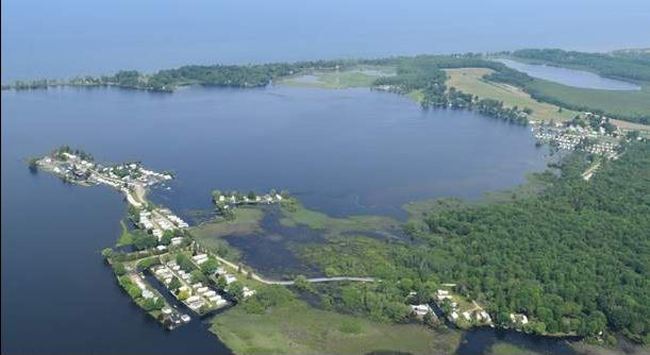
Aerial views of Greene Point Marina in Sandy Creek and the Brennans Bay RV Park in Mannsville on June 12 show high water levels from Lake Ontario and subsequent flood damage. Credit: Geoff Steadman and Thomas Hart.
Watertown, NY, Saturday, April 28, 2018 - Officials with the New York Sea Grant said a survey of waterfront residents affected by last year’s record high water levels on Lake Ontario could help communities prepare for future flooding.
“The results from the survey may validate where types of flooding may happen in the future under similar water levels,” said Mary Austerman, New York Sea Grant coastal community development specialist. “This may help in future planning.”
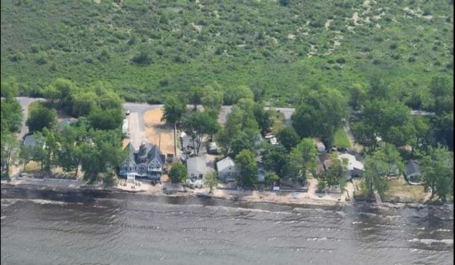
The shoreline of Jefferson Park, Ellisburg, which sits on Lake Ontario, on June 12, 2017. Credit: Geoff Steadman and Thomas Hart.
Taking responses from almost 500 property owners along the lake in New York, more than 60 percent of respondents said the foundation or first floor of their main structure was inundated with water, and 25 percent had erosion damage to their main structure.
“Yes, there were pockets of increased intensity, but the impacts were very widespread,” Mrs. Austerman said. “People didn’t anticipate that there’d be flooding in primary structures. That was surprising.”
The lengthy survey had respondents include detailed documentation of damage to their property, including pictures.
The survey found that 82 percent of respondents did not have flood insurance. On a scale of 1 to 10, with 10 being the most severe impacts, 61 percent said the damage was between 7 to 10.
The results could help inspire more long-term thinking from communities, Mrs. Austerman said.
“It’s in the long run less expensive to be proactive to be prepared for these threats they may encounter,” she said.
A photo of flooding in the town of Ellisburg in 2017, included as a part of the Coastal Flooding Survey Project assessing high water levels on Lake Ontario. Credit: Coastal Flooding Survey Project, Cornell University and New York Sea Grant.
The results of the survey may be paired with a similar effort being conducted by Canadian officials and the International Joint Commission, which could help paint a complete picture of the damage caused by the water levels.
“We’re working on trying to collaborate to get as much info as possible,” Mrs. Austerman said.
In addition to the resident survey, the Sea Grant also released a collection of aerial photos taken in June 2017 by environmental consultants Thomas Hart and Geoffrey Steadman along the shoreline of the lake.
Mrs. Austerman said the damage was clear at the elevated angle.
“People were around the shoreline, and noticed the ribbon of dirty water,” she said. “When you see the aerial, it looks like an excavator came out and scooped the shore in a straight line.”
The survey results and photos of the damage can be found at www.nyseagrant.org/waterlevel2017.
More Info: New York Sea Grant
New York Sea Grant (NYSG), a cooperative program of Cornell University
and the State University of New York (SUNY), is one of 33 university-based
programs under the National Oceanic and Atmospheric Administration’s
National Sea Grant College Program.
Since 1971, NYSG has represented a statewide network of integrated
research, education and extension services promoting coastal community
economic vitality, environmental sustainability and citizen awareness
and understanding about the State’s marine and Great Lakes resources.
Through NYSG’s efforts, the combined talents of university scientists
and extension specialists help develop and transfer science-based
information to many coastal user groups—businesses and industries,
federal, state and local government decision-makers and agency managers,
educators, the media and the interested public.
The program maintains Great Lakes offices at Cornell University, SUNY
Buffalo, SUNY Oswego and the Wayne County Cooperative Extension office
in Newark. In the State's marine waters, NYSG has offices at Stony Brook
University in Long Island, Brooklyn College and Cornell Cooperative
Extension in NYC and Kingston in the Hudson Valley.
For updates on Sea Grant activities: www.nyseagrant.org has RSS, Facebook, Twitter, and YouTube links. NYSG offers a free e-list sign up via www.nyseagrant.org/nycoastlines for its flagship publication, NY Coastlines/Currents, which is published quarterly. Our program also produces an occasional e-newsletter,"NOAA Sea Grant's Social Media Review," via its blog, www.nyseagrant.org/blog.