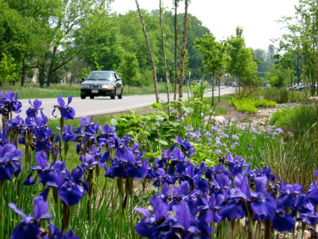
A vegetated swale, a low-lying and often wet stretch of land with attractive plantings, can treat and control storm water naturally. Credit: Thomas M. Robinson, Barton & Loguidice. Credit: Chris Gonzales/NYSG.
— By Chris Gonzales, Freelance Science Writer, New York Sea Grant
Ithaca, NY, July 12, 2018 - Three months and 12 days before I swerved to avoid hitting the dead possum, driving south on Route 96 toward Ithaca, I got an e-mail from my editor, Paul Focazio, communications manager for New York Sea Grant. It was one of his usual long lists of ideas for success stories about the organization.
The topic was “Small Grants Projects,” which I knew could be described in dry terms: 13 projects, $281,000 in grants, made in partnership with New York State Department of Environmental Conservation. As part of a larger, multi-year partnership that continues to this day, and at least through 2022, their purpose is to help Great Lakes coastal communities enhance their resiliency to events like severe storms and protect water quality.
But in that moment, driving the car, I was just trying to avoid an accident, with the dead possum or otherwise.
“The point of the narrative is to show one or two examples in detail,” I had said to Paul on the phone. “Let’s highlight one or two interesting examples, actually go out into the field, make a visit, meet significant people and see places, to represent the whole, all of the good work being done.”
Before leaving for the trip, I sent Paul an outline, my idea for the structure of the piece: Start with a striking first-person scene or image, representative of the whole, the way a journalist might do when reporting a story involving some travel. I was thinking about going to Owasco Lake, where the objective would be to document the signs, which were such a small-seeming symbol. In the project’s report, the author called them “stream-road crossing markers.” The locations were less than an hour from my home.
These signs would be markers of a much bigger initiative—ecological and community-building projects across New York’s Great Lakes, projects that bore implications for the nation and beyond. North America and its Great Lakes were the center of a huge trade hub, a crossroads of energy, products, services, and consumers. In the Central New York and Finger Lakes Region, Owasco Lake was taking steps to protect drinking water quality, encouraging the public to become involved in stream protection, and raising awareness of the stream tributaries to the lake, the source of the region’s drinking water.
I even mentioned the idea that if an armadillo ran into my path, I’d put that detail in, to make the narrative seem more personal, and lifelike. I would swerve to avoid hitting the animal, and this swerve would represent some obstacle, some knowable unknown, a predictable uncertainty, suggesting that things would be alright, even though they would not feel alright, and that with knowledge and preparation, predictable human interactions with nature can go more smoothly.
So I was imagining this animal coming into my path before I even left for the trip.
"North Pond Resiliency Project" Project: A collection of aerial imagery shows the damage caused by high water at North Sandy Pond and eastern Lake Ontario. Among them is damage to the Greene Point Marina, Sandy Creek, changes to the pond's inlet, and erosion of critical dunes. Credit: Watertown Daily Times.
Let me give you a few project summaries:
[NOTE: Additional information on most of the projects listed below can be found in "Great Lakes Small Grants Projects: Summaries (2015-17)."
- One project is dedicated to improving coastal resilience and community stewardship on Grand Island, near Niagara Falls and Buffalo.
- Another project team conducted land and water site visits to inlet, pond, and coastal barrier locations near North Pond in Oswego County, with aerial photo reconnaissance, GIS based-mapping, and the identification of ecosystem management issues.
- Team members from one project protected 500 feet of shoreline from constant changes in weather patterns in the Village of Sodus Point.
- There were investigators examining a special kind of wave – a seiche, which can result in flooding in low-lying coastal areas – and its implications for shore erosion on Lake Erie.
- CurrentCast produced a daily, 60-second syndicated radio series and podcast about water stewardship and sustainability in the Great Lakes and surrounding watersheds.
- A separate team worked with four communities in Monroe and Wayne Counties along the Lake Ontario shoreline to provide outreach and education about the FEMA Community Rating System program, the goals of which are to reduce flood damage and foster comprehensive floodplain management.
- One group analyzed nutrient fluxes entering the lower Great Lakes in western New York, particularly phosphorus and nitrates that can lead to harmful algal blooms (HABs).
- Some investigators implemented a bi-national water quality monitoring system on the St. Lawrence River, between Cornwall, Ontario, in Canada, and New York State.
- The Onandaga Lake Conservation Corps and Onandaga Nation Youth Group removed invasive Phragmites and planted native trees and shrubs, as part of winter tree identification study and land restoration activities. In addition, in summer, they performed stream restoration, giving youth the opportunity to play in the stream while learning about macroinvertebrates, and to monitor the earlier spring tree plantings.
- A team of engineers and professionals have been planning and designing a natural shoreline demonstration project for Port Bay's East Barrier Bar on Lake Ontario.
- Concerned residents and experts near Cayuga Lake have been assessing nearshore algae growth, temperature, and water clarity. They have measured nutrient inputs into the lake, are educating residents about benthic algae versus harmful algal blooms (HABS), and are planning a remediation project.
I thought these projects were an impressive group. Yet as happens so often with small grants, their stories go untold. Unless…
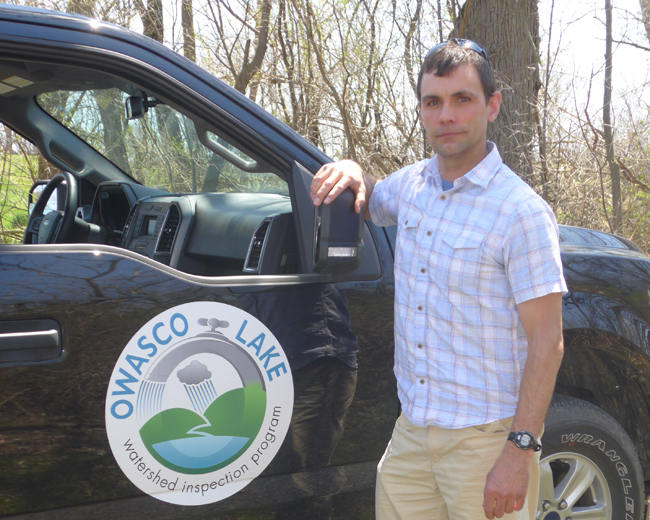
Andrew “Drew” Snell, Owasco Lake watershed specialist, poses in his "office." Credit: Chris Gonzales.
The sun climbs into a clear sky on a warm day, almost lulling me to sleep. It’s just after eleven o’clock in the morning, and I’m heading to Emerson Park, on Owasco Lake. After less than an hour of peaceful, event-free sunny driving, I’m waiting in the parking lot in this resort-like setting for the vehicle, a black Ford F-150 pickup that Andrew “Drew” Snell, water quality inspector for the Owasco Lake watershed, mentioned he would be driving. When the truck comes to a stop next to my car, his words are brief:
“Do you wanna go for a ride?”
Think pickup truck as mobile conference room. I climb in. Drew is in his mid-30s, I’d say. He wears sleek, sport-style outdoor sunglasses, has short-cropped hair. He’s trim and fit, suggesting he spends a lot of time outdoors traversing landscapes. He tells me he studied business and environmental studies at Clarkson University in Potsdam, New York. He is responsible for managing and monitoring an area of 208 square miles of watershed. Owasco Lake is the source of drinking water for the city of Auburn and the regional area. As he rolls off the facts, this ride doesn’t seem like work; it feels like play: a summery day in early May. We pass through a subdivision of manicured lawns near the shore, yard signs posted indicating a recent herbicide application. Phosphorous is banned as a lawn fertilizer, he explains, but too much nitrogen is becoming a problem. We head out of town, looking for the markers.
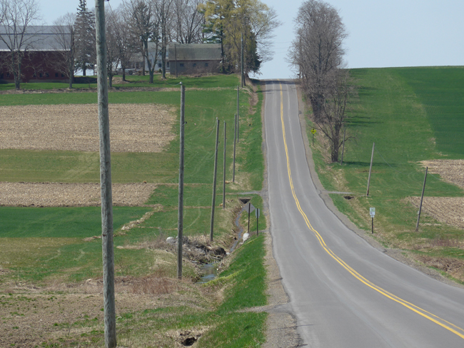
At the bottom of the hill, stream-road crossing markers indicate a tributary to Owasco Lake. Credit: Chris Gonzales.
The Owasco Lake Watershed Tributary Adoption and Identification Pilot Program (TAIPP) has installed sturdy, visually-appealing tributary stream-road crossing markers throughout portions of the Owasco Lake Watershed, in an effort to increase drinking water protective measures. The tributary crossing markers are designed to be simple, practical tools to educate the public, with quick response (QR) codes mapped to location-specific information. They encourage the public to report observable water quality concerns such as algal blooms, water discoloration, and toxic spills. The project has installed 50 signs at 25 stream-road crossings within six sub-watersheds near the lake.
As we drive, Drew speaks in cool tones, relaxed, seemingly focused on potential trouble spots, but indicating no alarm, just clear-eyed interest, observing.
He mentions a desire to use drones with thermal imaging sensors to detect failing septic systems. Since the waste water from inside a house is warmer, it would be detectable remotely, using a heat sensor, as it enters the lake.
“Drones have a huge potential to survey a large area quickly,” Drew says, checking for oncoming traffic, then entering the intersection and turning the pickup’s steering wheel. “With thermal sensors, you could hover in one spot and detect warmer water, seepage, entering the lake from below ground.”
My mind alights on the words “intersections,” and “interstices,” and rests there. I tell Drew I’m interested in these “stream-road crossing markers,” from his project, which seem more than just signs, but as points where the public will be crossing over a stream, or the natural world, from the road, or the built environment. “If you actually think about it,” I say, “it’s a huge symbol.”
“I’m glad you picked up on that. It’s really an effort to get the public to engage, to become more aware of how close they are to these natural resource pathways that carry our drinking water from its source to us.”
He told me he worries about keeping up with the physical and mental demands of the job. For one person, he has a lot of responsibility. He worries, but sees promise in new technologies that could make the job easier.
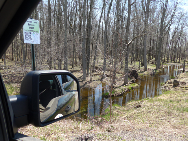
Quick response (QR) codes on stream-road crossing markers connect citizens to location-specific information and provide a way to report trouble. Credit: Chris Gonzales.
The quick response (QR) codes printed on the signs link to web pages for the specific location. They allow residents to report problems, learn about that specific area of the watershed, or the water quality and monitoring topic more generally. The public can learn what it can do to help.
While we are stopped at one stream-road crossing marker, an elderly gentleman in another F 150 pickup pulls up alongside us. The man leans over and manually cranks down the far passenger side window, says,
“Got a moment? I have something I want you to see. Let’s go.”
Drew says, “I can’t today. I’m with a visitor observing the signs.”
Signposts. And symbols.
“Can it be next week?” Drew asks.
“I can’t on Wednesday.”
“I can’t on Wednesday either. How about Tuesday?”
“Ok, Tuesday.”
So it was settled. After the man drove off, Drew explained that this type of encounter was very common. Folks wanting to report unusual sightings in their neighborhoods.
On our way back to Emerson Park, where we met up, we stop at the gatehouse where the attendant who let me pass earlier greets us.
“Go on in,” she says.
But Drew had already put the truck in park, as if inviting conversation.
It reminded me of how, on my way in to the park earlier that day, I told the gate attendant I was meeting Andrew Snell, the water quality inspector, and I was with New York Sea Grant. She had let me pass with little comment. But now, she asks Drew with a wry grin:
“Can you make the water quality better?”
“Every day,” he nods, and puts the truck in gear.
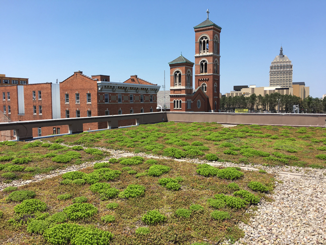
A green roof of succulents tops City Hall in Rochester, New York. This type of installation is cited in the Green Infrastructure Manual for its ability to retain and treat storm water, in addition to providing visual interest. Credit: Chris Gonzales.
I’m flipping through the virtual pages of the Green Infrastructure Manual. The goals of this free, electronic book: to educate planners, designers, and operations managers about green infrastructure and its benefits, such as better control of sediment, nutrient, and pathogen loadings in water; protection of drinking water; and onsite storm water management.
Examples of green infrastructure are tree planting; porous pavement—a type of pavement that allows water to pass through to the soil beneath; rain gardens, bioretention, and vegetated swales—areas of landscape that collect and treat runoff water through natural means such as vegetation; and other rainwater control systems such as collection and recycling, storm water planters, green roofs, and stream buffer restoration.
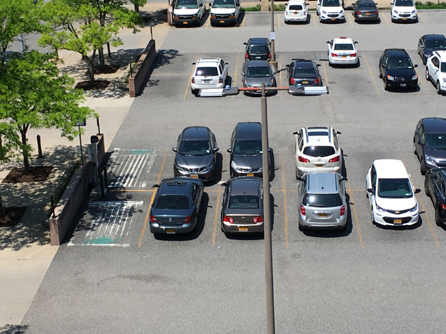
Next to City Hall, parking spaces are made of porous pavement, which lets water pass through to soil beneath. Credit: Chris Gonzales.
The outcomes of green infrastructure are the reduction of nuisance flooding and expensive water treatment costs, as well as the improvement of water quality. As an ancillary bonus, these techniques can enhance street appearance and give people an opportunity to interact with nature.
The creation of the Green Infrastructure Manual got underway in 2015, headed by Anne Spaulding, a manager in the city government of Rochester, New York, Division of Environmental Quality. A stakeholder group of planners, designers, and operations managers met in Rochester in the summer of 2016 and began contributing ideas. Funding came from the National Oceanographic and Atmospheric Administration, New York Sea Grant, and New York Department of Environmental Conservation to the tune of $25,000.
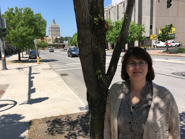
Anne Spaulding, manager in the city government of Rochester, New York, Division of Environmental Quality, stands in the shade of a street tree set in flexible porous pavement. Credit: Chris Gonzales.
“The guide could be applicable to any city in the world,” Spaulding says. “Parts of it are especially appropriate to northern climes where there is cold winter weather and rainfall, thawing and freezing periods, and so on.”
I had arrived for my meeting with Spaulding just a few minutes early, giving me enough time in the seating area to browse a trade magazine called Stormwater, “for surface water quality professionals.” Some of the concerns and emerging solutions of the sort featured in the Green Infrastructure Manual are discussed in the magazine. She takes me up to the roof of City Hall, where we see a roof garden with a cover of succulents. Just within a few block radius of the office building, there are several examples of rain gardens, bioretention systems, vegetated swales, and porous pavement installations. (See photos above and below).
The Green Infrastructure Manual gathers much of the latest techniques in sustainable surface water management, and provides details about how each type of system should be installed and maintained.
Some examples include: Tips for urban tree planting. How much drainage area will a tree provide? How do you calculate it? Avoid utilities. Permeable pavement and structural soil help water control and filtration. Bioretention techniques allow people to capture and treat runoff in a shallow storm basin or landscaped area. Rain gardens can manage and treat small volumes of rainwater by storing in shallow depression of soil materials and plants, usually with some type of overflow mechanism. In addition, the gardens create attractive points of interest in a landscape. Swales—low-lying or depressed and often wet stretches of land—contain drainage paths with vegetation to filter runoff. Storm daylighting, the process of uncovering a stream or section of a stream that had been artificially enclosed to accommodate development, can improve water quality. There’s a wealth of information about these techniques, as well as specifications to implement them in urban settings.
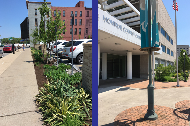
(At left) An example of a bioretention area, which collects and treats storm water naturally. (At right) A few blocks from City Hall, the Monroe County Crime Laboratory features a rain garden. Credit: Chris Gonzales.
On my way home, I’m driving south on Route 96 toward Ithaca. I swear I tell the truth. A large, dark object loomed in my lane, and as I got closer, I realized it was a possum or larger, brown mammal, killed by a preceding car. I couldn’t steer to the left, because there was an oncoming car. Later, when I was replaying the incident in my mind, I realized that this was the exact sort of road hazard I imagined I might encounter. It’s like dealing with surface water quality, say, or a larger environmental problem. It’s a knowable unknown, a predictable uncertainty, and with knowledge and preparation, your encounter with nature will go with fewer troubles. It’s nature saying, “Hey!” When the moment arrives, you don’t think about all the planning you have done, or that you’ve trained your mind to expect a situation. You calmly swerve, and keep on going. Now, if we can just get more people thinking about water quality, or environmental quality more generally, and that mental swerve.
I slowed the car, gently steered onto the shoulder, and passed the obstacle without incident, adjusting my course toward home.
More Info: New York Sea Grant
New York Sea Grant (NYSG), a cooperative program of Cornell University
and the State University of New York (SUNY), is one of 33 university-based
programs under the National Oceanic and Atmospheric Administration’s
National Sea Grant College Program.
Since 1971, NYSG has represented a statewide network of integrated
research, education and extension services promoting coastal community
economic vitality, environmental sustainability and citizen awareness
and understanding about the State’s marine and Great Lakes resources.
Through NYSG’s efforts, the combined talents of university scientists
and extension specialists help develop and transfer science-based
information to many coastal user groups—businesses and industries,
federal, state and local government decision-makers and agency managers,
educators, the media and the interested public.
The program maintains Great Lakes offices at Cornell University, SUNY
Buffalo, SUNY Oswego and the Wayne County Cooperative Extension office
in Newark. In the State's marine waters, NYSG has offices at Stony Brook
University in Long Island, Brooklyn College and Cornell Cooperative
Extension in NYC and Kingston in the Hudson Valley.
For updates on Sea Grant activities: www.nyseagrant.org has RSS, Facebook, Twitter, and YouTube links. NYSG offers a free e-list sign up via www.nyseagrant.org/nycoastlines for its flagship publication, NY Coastlines/Currents, which is published quarterly. Our program also produces an occasional e-newsletter,"NOAA Sea Grant's Social Media Review," via its blog, www.nyseagrant.org/blog.