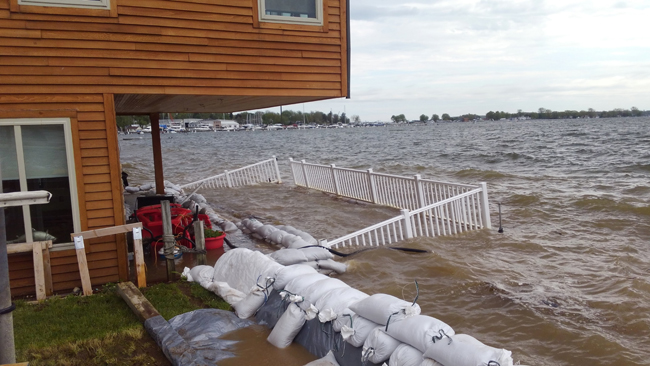
Inundation on Sodus Bay, a Lake Ontario embayment, in 2017. Credit: Mary Austerman, NYSG.
NYSG’s interactive Lake Ontario inundation mapping tools help communities and property/business owners enhance their flooding preparedness
Contact:
Mary Austerman, NYSG Great Lakes Coastal Community Specialist, E: mp357@cornell.edu, P: (315) 331-8415
Jessica A. Kuonen, NYSG Hudson Estuary Resilience Specialist, E: jak546@cornell.edu, P: (845) 340-3990 x323
Newark, NY, March 2, 2020 - Record-high water levels were reached in two of the last three years on Lake Ontario. As a result of efforts to help communities and property owners develop resiliency for any such future events, New York Sea Grant (NYSG) took the initiative to address the needed ability to visualize parcel-level flood risk.
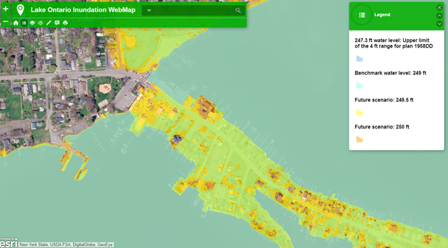
NYSG has created online, interactive mapping tools that provide users with the ability to see parcel-level views of flood-risk predictions along Lake Ontario and its embayments. These mapping tools were developed with Lake Ontario community leaders as the intended primary beneficiary, however, the tools will also be helpful to waterfront residents and business owners.
The maps, based on predetermined water levels and digital elevation data, overlay different water levels to bring awareness about infrastructure and services that may be at risk. Using the highest quality elevation data available for each of New York’s Lake Ontario counties, and applying a “bathtub method,” inundation layers were created based on the elevation of static water.
The visualization of inundation scenarios derived from these mapping tools may be used to consider property planning (e.g., location/triage of accessory structures and belongings during high water), to identify areas prone to inundation to inform community-level preparedness planning, or to address areas that warrant in-depth analyses.
Examples of community-based activities that can be informed by these tools include enhancing flood response (sandbag prioritization) and local policy for post-flood resilience. Currently, with wave run-up data not readily available, generated maps assume only flat water associated with lake levels, not stormwater drainage issues.
NYSG’s new inundation mapping tools help communities and coastal property owners enhance flooding preparedness.
The Lake Ontario mapping tools were developed as part of a larger NYSG project creating a Coastal Resiliency Index. The tools’ developers NYSG Coastal Community Development Specialist Mary Austerman (concept) and NYSG Hudson Estuary Specialist Jessica Kuonen (interactive design) are considering a similar mapping tool for Lake Erie. For more information, contact the New York Sea Grant: Newark office at 315-331-8415.
NYSG Lake Ontario Inundation Mapping Tools & Step-by-Step User Guides: www.nyseagrant.org/ccd > Resources > Tools.
The Sea Grant Focus Area for this project is Resilient New York Communities and Economies.
Project Partner:
• National Oceanic and Atmospheric Administration Community Climate Adaptation Initiative (funding)
More Info: New York Sea Grant
New York Sea Grant (NYSG), a cooperative program of Cornell University
and the State University of New York (SUNY), is one of 34 university-based
programs under the National Oceanic and Atmospheric Administration’s
National Sea Grant College Program.
Since 1971, NYSG has represented a statewide network of integrated
research, education and extension services promoting coastal community
economic vitality, environmental sustainability and citizen awareness
and understanding about the State’s marine and Great Lakes resources.
Through NYSG’s efforts, the combined talents of university scientists
and extension specialists help develop and transfer science-based
information to many coastal user groups—businesses and industries,
federal, state and local government decision-makers and agency managers,
educators, the media and the interested public.
The program maintains Great Lakes offices at Cornell University, SUNY
Buffalo, SUNY Oswego and the Wayne County Cooperative Extension office
in Newark. In the State's marine waters, NYSG has offices at Stony Brook
University in Long Island, Brooklyn College and Cornell Cooperative
Extension in NYC and Kingston in the Hudson Valley.
For updates on Sea Grant activities: www.nyseagrant.org has RSS, Facebook, Twitter, and YouTube links. NYSG offers a free e-list sign up via www.nyseagrant.org/nycoastlines for its flagship publication, NY Coastlines/Currents, which is published quarterly. Our program also produces an occasional e-newsletter,"NOAA Sea Grant's Social Media Review," via its blog, www.nyseagrant.org/blog.