Rip currents and rough surf can prove challenging at state parks and beaches. Credit: Michael M. Santiago/Getty Images
Will Beaches Open By Labor Day?
— Filed by Nsikan Akpan for WNYC's Gothamist
New York, NY, Aug 30, 2023 - Gov. Kathy Hochul suspended swimming at three Long Island state beaches as rough surf and rip tides and flooding as the effects of faraway storms continue to hit the region.
New York City officials also issued a coastal flood advisory and warned that life-threatening rip currents could be present through Thursday. The Parks Department advised against swimming in areas without lifeguards, but an agency spokesperson said late Wednesday afternoon that city beaches would remain open to swimming.
“We are continuing to monitor the forecast and currents, and will take appropriate action as necessary,” NYC Parks senior press officer Dan Kastanis said via email.
But weather officials said they were hopeful the waters will calm in time for Labor Day weekend.
The choppy waves are due to hurricanes Franklin and Idalia — even though neither storm is due to come within 500 miles of New York waterways. Franklin rapidly intensified into a Category 4 hurricane on Monday, as the cyclone churned its way from the tropics into the North Atlantic.
Hurricane Idalia trailed not too far behind, making landfall as a Category 3 on Florida’s panhandle Wednesday morning. It’s due to travel through The South and then exit due east over the Carolinas.
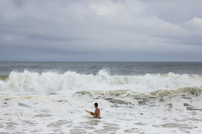
Despite their distance, both storms are creating swell waves — giant rolling masses of water that can travel long distances. Josh Kohut, a Rutgers University professor who studies physical oceanography, said these swells tend to get measured in two ways. First, there is the height or amplitude — the distance between the trough of the wave and its crest. The closer you are to the center of the storm, the higher the waves are going to be.
“The other measure we take is the wave period. That's how much time it takes to go from one crest to the next crest,” Kohut said.
Swells tend to have longer periods — meaning more time passes before each one hits shore. Kohut said if beachgoers sit in the sand and count 10 seconds or more between the arriving waves, then they are witnessing swells. Smaller waves generated locally by the breeze tend to arrive about five seconds apart.

Man sits on a bench in flood waters after Hurricane Idalia passed offshore on Aug. 30, 2023 in Crystal River, Florida. Credit: Joe Raedle/Getty Images
When swells encounter shore, the water piles as far up land as it can, causing the high surf. But what goes up must come down, leading to the opposite effect: hazardous rip tides that can pull unsuspecting swimmers out to sea.
Over the past decade, rip currents were the third-leading cause of weather fatalities in the U.S., behind only heat waves and floods. Kathleen Fallon, New York Sea Grant's coastal processes and hazards specialist, said flash rip currents are the most common type of rip currents on the South Shore.
They’re sporadic, last a few minutes and are caused by waves breaking in short sections, according to the National Weather Service. Rip currents often form around human-made structures like jetties when they run perpendicular to the beach — basically, near stuff that channels water from the beach into the ocean.
“The traditional messaging has been if you find yourself being pulled away from the shoreline to swim to the right or to the left, parallel the shoreline to escape that flow moving away from the shore,” said Fallon, who partners on studies to create bilingual communication warning tools about rip currents. “Once you're out of that, swim back towards the shoreline.”
Dominic Ramunni, a meteorologist with the National Weather Service’s New York office, said Thursday would carry the highest risk of high surf and rip currents.
“A high surf advisory is in effect for Suffolk County beaches right now through 6 p.m. on Thursday,” he said. “That's for six-to-eight-foot surf along the shore.”
Ramunni added that the risks increase the further east one travels along Suffolk County beaches and that the high surf would be closer to five or six feet near New York City and New Jersey.
He expects the high surf and rip tides to be smaller but still elevated on Friday, but conditions should quiet down by the weekend.
“Those storms will exit and remain well offshore and we will see high pressure move in over the region, above us. That sets us up for almost a beautiful Labor Day weekend,” Ramunni said. “A little warm as we go into Labor Day itself. But those headed the beach should be able to step into the water if they're so inclined.”
More Info: New York Sea Grant
New York Sea Grant (NYSG), a cooperative program of Cornell University
and the State University of New York (SUNY), is one of 34 university-based
programs under the National Oceanic and Atmospheric Administration’s
National Sea Grant College Program.
Since 1971, NYSG has represented a statewide network of integrated
research, education and extension services promoting coastal community
economic vitality, environmental sustainability and citizen awareness
and understanding about the State’s marine and Great Lakes resources.
Through NYSG’s efforts, the combined talents of university scientists
and extension specialists help develop and transfer science-based
information to many coastal user groups—businesses and industries,
federal, state and local government decision-makers and agency managers,
educators, the media and the interested public.
The program maintains Great Lakes offices at Cornell University, SUNY
Buffalo, SUNY Oswego and the Wayne County Cooperative Extension office
in Newark. In the State's marine waters, NYSG has offices at Stony Brook
University and with Cornell Cooperative Extension of Nassau County on Long Island, Brooklyn College and Cornell Cooperative
Extension in NYC and Kingston in the Hudson Valley.
For updates on Sea Grant activities: www.nyseagrant.org has RSS, Facebook, Twitter, Instagram, and YouTube links. NYSG offers a free e-list sign up via www.nyseagrant.org/nycoastlines for its flagship publication, NY Coastlines/Currents, which is published quarterly.