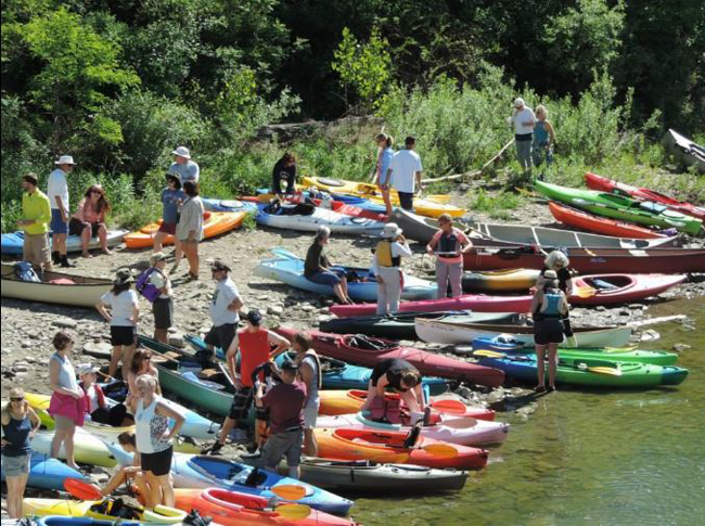
A Genesee River Wilds float draws a crowd to the river. Credit: File Photo
Genesee RiverWatch aims to have map out in 2020
Published by the Wellsville Daily Reporter
NOTE: This research is related to a 2017-18 Great Lakes small grant funded through New York Sea Grant and the NYS Department of Environmental Conservation. The project was led by the Genesee RiverWatch. More on that and other projects in the series at "NYSDEC and NY Sea Grant Announce $199,575 in Grants for Great Lakes Basin Projects."
BELMONT, NY, December 30, 2019 — Imagine a map that would tell Genesee River kayakers from Wellsville to Rochester where to find the nearest general store, restaurant and lodging, no matter where they step out of the river.
Genesee RiverWatch is working to make that map a reality. The Rochester-based non-profit recently held a trio of informational sessions along the river, including one at the Crossroads Center in Allegany County.
RiverWatch conducted the meetings with two aims in mind — soliciting ideas for new river access sites and gathering input on the map. Both goals support the overarching mission of making the river more accessible to recreation.
“There’s a lot of people in Rochester who have no clue what this area is like,” said Executive Director George Thomas. “There’s a million people up there [in Rochester] and a very small fraction have any clue about what this is like down here. You have to have a personal relationship with somebody to tell you where to go. We need something that’s a little bit more friendly to people to have access to, so they know where to go. That’s what we’re thinking about.”
RiverWatch received funding for the project through a New York Sea Grant. Local organizations Genesee River Wilds and the Allegany County Office of Tourism provided early support for the map concept.
The group envisions both print and digital versions of the map, connecting communities along the river like never before.
“If people are going to hit a QR code at one of these access points, what is it going to take them to?” asked Thomas. “What are the things we should have on the map? If people are planning a trip and want to get outfitted for it, because a lot of people don’t have equipment, this would tell them what’s available.”
The map could also serve as a driver of tourism dollars to local businesses, telling newcomers to the area where to find the closest bite to eat or place to stay during overnight trips. Nearby sites of historical interest could also be included.
Having such information at one’s fingertips on a smartphone could also ease the shuttling process for kayakers, Thomas said. RiverWatch hopes to have the map out in early 2020 ahead of the kayaking season.
The map would feature all of the current access sites along the river. Thomas noted Allegany County is fortunate to boast a large number of access sites already available for kayakers.
“There’s a lot. You look at that map and there’s no comparison, especially with the middle part of the river,” Thomas said. “If you get up in Rochester you can’t hardly get in the river anywhere. The water is also different here. You can walk up to the water. You can’t do that in other areas of the river.
“Plus you’ve had a group, Genesee River Wilds, dedicated to that concept for years. They’ve done a nice job. There are still sites that need work. In another 10 years that site in Caneadea won’t be there (due to erosion). Those are the kind of things we’re looking for, and are those spots in there we need a new site?”
Allegany County “where all the action is”
Erosion control is also a core mission of Genesee RiverWatch. Valuable farmland in Allegany County is lost every year. The runoff in Allegany County travels the rest of the river and results in decreased water quality all the way to Lake Ontario.
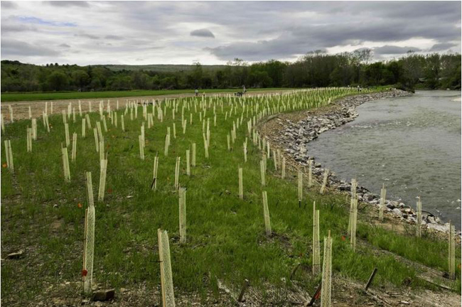
A Genesee RiverWatch riverbank stabilization project in Belfast. Credit: File Photo
Genesee RiverWatch has stabilized large chunks of riverbank in Belfast and Hume in partnership with local landowners. The non-profit has applied for funding for seven more erosion control projects, all in Allegany County.
“That’s where all the action is, that’s where all the erosion is,” Thomas said.
RiverWatch is working on its largest project to date in Angelica, a 3,200 foot stretch owned by Rob Chamberlain that is being tackled with help from the US Fish and Wildlife Service. Another project is in the works just south of Houghton on property owned by Mallards Dairy Farm, which partnered with RiverWatch on its first project in Belfast in 2018.
A future target is the current river access site on state Route 19 in Caneadea, which Thomas said is “eroding like crazy.” That’s one of several projects on the agenda in the Caneadea and Houghton area.
The urgency for action grows with every high-water event.
“Edelweiss Farms lost 14 acres in a 10-year period,” Thomas said. “We only have five years to do those projects if we get the money. If we get the money we’ll have the wherewithal to do them.”
The need isn’t limited to the Genesee River itself. Canaseraga Creek, one of its tributaries, is the second biggest contributor to phosphorus and sediment in the Basin.
The previous erosion control projects featured major volunteer tree-planting efforts to cap the riverbank stabilization with a riparian buffer. Thomas said RiverWatch is fine tuning its approach in that area. In the future the group may plant fewer, larger trees to avoid deer damage.
“Rather than plant 1,800 bareroot seedlings, maybe we plant 300-400 bigger trees,” he said. “We’d be happy with a 40 percent survival rate. The trees are growing in the tube, but the deer eat the top and they’re having a hard time growing out of the tubes. If you have a tree that’s six or eight feet tall, they might have a better chance. Those are things we’re considering. We’re always looking for a better way to do it and still accomplish the task.
For more information or to get involved, visit geneseeriverwatch.org.
“There’s a lot to be done, but it’s doable. It’s not impossible. I think we can make a significant impact.”
More Info: New York Sea Grant
New York Sea Grant (NYSG), a cooperative program of Cornell University
and the State University of New York (SUNY), is one of 34 university-based
programs under the National Oceanic and Atmospheric Administration’s
National Sea Grant College Program.
Since 1971, NYSG has represented a statewide network of integrated
research, education and extension services promoting coastal community
economic vitality, environmental sustainability and citizen awareness
and understanding about the State’s marine and Great Lakes resources.
Through NYSG’s efforts, the combined talents of university scientists
and extension specialists help develop and transfer science-based
information to many coastal user groups—businesses and industries,
federal, state and local government decision-makers and agency managers,
educators, the media and the interested public.
The program maintains Great Lakes offices at Cornell University, SUNY
Buffalo, SUNY Oswego and the Wayne County Cooperative Extension office
in Newark. In the State's marine waters, NYSG has offices at Stony Brook
University in Long Island, Brooklyn College and Cornell Cooperative
Extension in NYC and Kingston in the Hudson Valley.
For updates on Sea Grant activities: www.nyseagrant.org has RSS, Facebook, Twitter, and YouTube links. NYSG offers a free e-list sign up via www.nyseagrant.org/nycoastlines for its flagship publication, NY Coastlines/Currents, which is published quarterly. Our program also produces an occasional e-newsletter,"NOAA Sea Grant's Social Media Review," via its blog, www.nyseagrant.org/blog.