Stony Brook, NY, December 5, 2012 - When Superstorm Sandy made landfall on October 29, 2012, with its damaging winds and storm surge, it took a toll especially on Long Island’s populous south shore where lives, properties and infrastructure were devastated. One of New York’s well-known barrier islands, Fire Island, was also hard hit. During such an extreme weather event, overwash channels on Fire Island grew and deepened, eventually forming several breaches, or openings, in the barrier island that allowed water to flow between the Great South Bay and the Atlantic Ocean. Sand moving along the coast helped to fill several of these breaches naturally soon after the storm and some were aided by the Army Corps of Engineers.
The formation of breaches and new inlets along Long Island's south shore barrier island system is a topic of intense interest among coastal planners, managers, decision-makers and the public. Due to the dynamic nature of the processes operating along the coast, new inlets can have a profound impact on the back bay ecosystems. Because these bays are important and productive habitats for a variety of environmentally and economically important species, there is considerable concern about how these physical changes may, in turn, affect living resources found there.
In a New York Sea Grant (NYSG) report funded by the National Park Service in 2001 entitled Impacts of Barrier Island Breaches on Selected Biological Resources of Great South Bay, New York, editors Jay Tanski (New York Sea Grant’s coastal processes specialist), Henry Bokuniewicz (Stony Brook University’s School of Marine and Atmospheric Sciences), and Cornelia Schlenk (New York Sea Grant’s Assistant Director) summarized research presented by a panel of experts at a workshop early in 2001 which covered numerical modeling of breach impacts on Great South Bay, water column productivity, submerged and intertidal aquatic vegetation, shellfish and benthic invertebrates, and finfish. Interestingly, one of the models illustrated in the report shows the potential for a breach at Old Inlet, the site of a large breach formed during the storm. The 103-page report is available as a download (pdf).
Tanski is also the author of Long Island’s Dynamic South Shore: A Primer on the Forces and Trends Shaping Our Coast (click here).
New York Sea Grant, a cooperative program of Cornell University and the State University of New York, is one of 33 university-based programs under the National Sea Grant College Program (NSGCP) of the National Oceanic and Atmospheric Administration (NOAA). This network also includes a National Sea Grant Law Center and National Sea Grant Library. Through its statewide network of integrated services, NYSG has been promoting coastal vitality, environmental sustainability, and citizen awareness about the State’s marine and Great Lakes resources since 1971. For updates on New York Sea Grant activities, www.nyseagrant.org has RSS, Facebook, Twitter and YouTube links. NYSG also offers a free e-list sign-up via www.nyseagrant.org/nycoastlines for NY Coastlines, its flagship publication, and Currents, its e-newsletter supplement, each distributed 3-4 times a year.
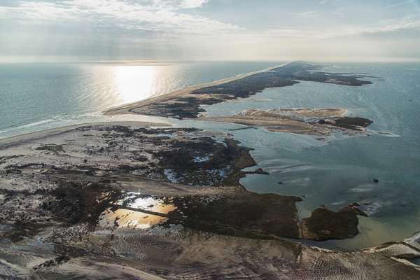
"Old Inlet" breach in Fire Island caused by Sandy. Photo by National Park Service