New Eastern Lake Ontario project to track historic storm events along the eastern shore of Lake Ontario
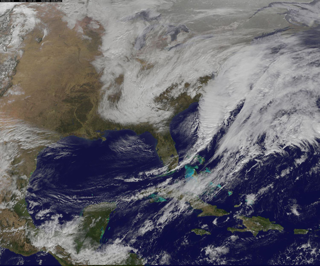
NOAA's GOES-East satellite captured the center of a developing Nor'easter located off North Carolina's Outer Banks on Jan. 26, 2015 in the image from 12:30 p.m. EST. GOES satellites provide the kind of continuous monitoring necessary for intensive data analysis. Credit: NASA/NOAA Goes Project
Contacts:
Dave White, New York Sea Grant, P: 315-312-3042, E: dgw9@cornell.edu
Kara Lynn Dunn, Publicist, P: 315-465-7578, E: karalynn@gisco.net
Oswego, NY, March 16, 2015—New York Sea Grant has received funding from the National Oceanic and Atmospheric Administration (NOAA) through the National Sea Grant College Program to track historic storm events along the eastern shore of Lake Ontario. The project will create a climatological event database to better assist risk projection to help communities increase their storm event resiliency.
“This project will create a well-documented Great Lakes climatology resource that will serve as a benchmarking resource for eastern Lake Ontario shore communities similar to risk projection tools already available to East Coast stakeholders facing storms that impact the Atlantic coastline,” says New York Sea Grant Associate Director Katherine Bunting-Howarth, based at Cornell University, Ithaca, NY.
New York Sea Grant is recognized as a leader in developing coastal storm awareness resources for the marine district of New York State.
Specific focus areas for this pilot project will be the fragile dunes areas along Lake Ontario in Oswego and Jefferson counties and the Sodus Bay area with a 7,500-foot-long barrier beach in Wayne County.
The project will develop a monitoring program to track storm impacts, such as erosion and structure damage, and will revive periodic photo monitoring of the dunes areas to show changes over time. In the past, New York Sea Grant photo monitoring of the 17-mile Eastern Lake Ontario Dune and Wetland Area has shown the success of beachgrass restoration plantings that help stabilize the sand dunes.
Project leader David G. White, a coastal recreation and tourism specialist with New York Sea Grant at SUNY Oswego, says the historical retrospective on Great Lakes storms will include review of stakeholder reports, maps and meteorological data on historic storm damage going back to 1950.
“We will be looking at such factors as storm and wind speed, pressure points, wave action in addition to aerial and ground photography of coastal impacts,” White says.
Project partners include the National Oceanic and Atmospheric Administration Northeast Regional Climate Center at Cornell University; the Cornell University Department of Earth and Atmospheric Sciences; County Soil and Water Conservation Districts in Jefferson, Oswego and Wayne counties; local municipal leaders and citizen groups, such as the Friends of Sandy Pond Beach; and private landowners.
The project results will be available as web-based resources to help shoreline stakeholders reduce the impact of coastal storms on dunes, beaches, properties and improve coastal resiliency and sustainability. Watch the New York Sea Grant Web site at www.nyseagrant.org for details.
More Info:
NOAA/Sea Grant's Coastal Storms Funding
Funding for this effort comes through a "Special Projects Funding Announcement" released in April 2014 by NOAA's Coastal Storms Program and the National Sea Grant College Program. The funding—up to $64,000 in total federal monies—is being used through August 2016 to support program development within the Great Lakes Sea Grant Network in the area of hazards and coastal storm resilience.
In a separate coastal storms effort, New York Sea Grant, Connecticut Sea Grant and New Jersey Sea Grant were awarded $1.4 million in funding in January 2014 via NOAA to 10 social science research projects to improve community understanding and response to coastal storm hazard information as part of the NOAA Sea Grant Coastal Storm Awareness Program (CSAP). The findings from the program's projects are intended to raise awareness of how severe weather is communicated to and within communities. Additional information on CSAP can be found at www.nyseagrant.org/csap.
NOAA
NOAA's mission is to understand and predict changes in the Earth's
environment, from the depths of the ocean to the surface of the sun, and
to conserve and manage our coastal and marine resources. Join NOAA on Twitter, Facebook and our other social media channels and visit the organization's news release archive.
New York Sea Grant
New York Sea Grant (NYSG), a cooperative program of Cornell University
and the State University of New York, is one of 33 university-based
programs under the National Sea Grant College Program (NSGCP) of the
National Oceanic and Atmospheric Administration (NOAA). The NSGCP
engages this network of the nation’s top universities in conducting
scientific research, education, training and extension projects designed
to foster science-based decisions about the use and conservation of our
aquatic resources. Through its statewide network of integrated
services, NYSG has been promoting coastal vitality, environmental
sustainability, and citizen awareness about the State’s marine and Great
Lakes resources since 1971.
For updates on Sea Grant activities: www.nyseagrant.org has RSS, Facebook, Twitter, and YouTube links. NYSG also offers a free e-list sign up via www.nyseagrant.org/coastlines for its flagship publication, NY Coastlines/Currents, which is published several times a year.