NOAA services before, during, after storms saved lives and aided recovery
Contact:
Lauren Gaches, NOAA's National Centers for Environmental Prediction, E: lauren.gaches@noaa.gov, P: 301-683-1327
Washington, D.C., November 28, 2018 - The 2018 Atlantic hurricane season officially concludes on November 30, and will be remembered most for hurricanes Florence and Michael, which caused significant damage in the southeastern U.S. In total, the season produced 15 named storms, including eight hurricanes of which two were “major” (Category 3, 4 or 5). An average season has 12 named storms, six hurricanes, and three major hurricanes.
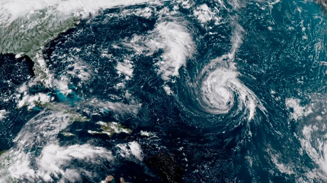
This enhanced satellite image shows Tropical Storm
Florence, center, in the Atlantic Ocean in the afternoon of on
Saturday, September 8, 2018. By the following morning the storm was
upgraded to hurricane status. Credit: NOAA.
“From the start of the 2018 hurricane season to its conclusion, NOAA and its dedicated staff of scientists, researchers, and forecasters have remained on the frontlines, saving countless American lives with critical and accurate data,” said U.S. Secretary of Commerce Wilbur Ross. “Time and again NOAA and NOAA resources have proven their value to the American people during the most urgent of circumstances.”
Storm-by-storm forecasts from NOAA’s National Hurricane Center were aided by the high-resolution imagery from NOAA’s new GOES-East satellite (GOES-16), and the American Global Forecast System (GFS) model, which produced accurate forecasts of landfall location and timing for both hurricane Florence and Michael. NOAA’s hurricane hunter aircraft flew more than 580 hours this season and provided valuable data in support of forecasting, research and emergency response.
The 2018 Atlantic hurricane season officially concludes on Nov. 30. This imagery from NOAA’s GOES-East (GOES-16) satellite shows the entire six-month season from start to end, condensed into one minute. Credit: NOAA.
“This season packed a strong punch, but its impacts could have been far worse had it not been for the services NOAA provided alongside our emergency management partners and the preparedness activities taken by individuals,” said Neil Jacobs, Ph.D., NOAA assistant secretary of commerce for environmental observation and prediction.
Strong coordination between the National Hurricane Center, NOAA’s Weather Prediction Center and local weather and river forecast offices assisted decision-making among emergency managers at federal, state and local levels. Where needed, staffing surges allowed forecast offices to provide enhanced information to decision-makers, improving the local ability to carry out timely evacuations, close roads and protect vulnerable infrastructure without compromising forecast operations.
This season, NOAA and the U.S. Navy launched the most unmanned ocean gliders ever used in support of Atlantic hurricane forecasts. These gliders collected more than 40,000 temperature and salinity profiles that were fed into operational and experimental hurricane forecast models. NOAA scientists also flew an unmanned aircraft into the eyewall of Hurricane Michael and transmitted data to help researchers better understand this turbulent part of the storm to improve future hurricane prediction.
Additionally, NOAA's National Ocean Service provided water level forecasts and monitoring for areas in the path of the storm, supported the U.S. Coast Guard to reopen the nation's ports, helped to identify and safely remove pollutants from abandoned vessels, and collected aerial imagery to assess damage from the storm in order to speed recovery and response efforts.
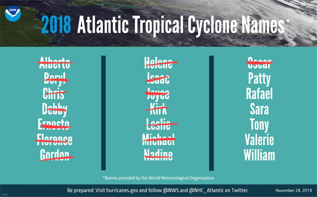
A graphic showing 2018 Atlantic tropical cyclone names selected by the World Meteorological Organization. This year, there were 15 named storms, ending with Oscar. Credit: NOAA.
For the fourth consecutive year, hurricane activity began prior to the official June 1st start of the season, with Tropical Storm Alberto forming on May 25. Alberto made landfall in northern Florida and traveled as far north as the Great Lakes as a tropical depression.
A record seven named storms (Alberto, Beryl, Debby, Ernesto, Joyce, Leslie and Oscar) were classified as subtropical at some point. The previous record of five subtropical storms occurred in 1969. A subtropical storm is a named storm that has tropical and non-tropical characteristics. All subtropical storms this season eventually transitioned into a tropical storm, with three (Beryl, Leslie and Oscar) eventually becoming hurricanes.
The 2018 hurricane season was the first since 2008 to have four named storms active at the same time (Florence, Helene, Isaac and Joyce). Hurricane Florence caused catastrophic flooding in portions of North and South Carolina. Several river forecast locations in the Carolinas approached or broke their record flood level in the days and weeks following the hurricane. It took two to three weeks for many river locations to fall below flood stage, and the final river crested one month after Florence made landfall.
The NOAA Hurricane Hunters completed their final flight into Hurricane Michael on October 10, 2018. Here is a look at what they experienced as they passed through the hurricane in one of NOAA's Lockheed WP-3D Orion "hurricane hunter" aircraft before the storm made landfall. Credit: NOAA's Hurricane Research Division of the Atlantic Oceanographic and Meteorological Laboratory.
Hurricane Michael, at a Category 4 intensity, was the strongest hurricane on record to strike the Florida panhandle. It was the third-most-intense hurricane to make landfall in the continental U.S. on record in terms of central pressure (919 mb) and the fourth-strongest in terms of maximum sustained winds (155 mph).
“The 2018 season fell within NOAA’s predicted ranges in our pre-season outlook issued in late May. However, the overall season was more active than predicted in the updated outlook issued in early August,” said Gerry Bell, Ph.D., lead seasonal hurricane forecaster at NOAA’s Climate Prediction Center. “Warmer Atlantic Ocean temperatures, a stronger west-African monsoon and the fact that El Nino did not form in time to suppress the season helped to enhance storm development.”
With lessons learned from the 2018 hurricane season still fresh in memory, now is the time to make note of ways to improve family hurricane plans for next year. The 2019 hurricane season will officially begin on June 1 and NOAA’s Climate Prediction Center will provide its initial seasonal outlook in May.
More Info: New York Sea Grant
New York Sea Grant (NYSG), a cooperative program of Cornell University
and the State University of New York (SUNY), is one of 33 university-based
programs under the National Oceanic and Atmospheric Administration’s
National Sea Grant College Program.
Since 1971, NYSG has represented a statewide network of integrated
research, education and extension services promoting coastal community
economic vitality, environmental sustainability and citizen awareness
and understanding about the State’s marine and Great Lakes resources.
Through NYSG’s efforts, the combined talents of university scientists
and extension specialists help develop and transfer science-based
information to many coastal user groups—businesses and industries,
federal, state and local government decision-makers and agency managers,
educators, the media and the interested public.
The program maintains Great Lakes offices at Cornell University, SUNY
Buffalo, SUNY Oswego and the Wayne County Cooperative Extension office
in Newark. In the State's marine waters, NYSG has offices at Stony Brook
University in Long Island, Brooklyn College and Cornell Cooperative
Extension in NYC and Kingston in the Hudson Valley.
For updates on Sea Grant activities: www.nyseagrant.org has RSS, Facebook, Twitter, and YouTube links. NYSG offers a free e-list sign up via www.nyseagrant.org/nycoastlines for its flagship publication, NY Coastlines/Currents, which is published quarterly. Our program also produces an occasional e-newsletter,"NOAA Sea Grant's Social Media Review," via its blog, www.nyseagrant.org/blog.