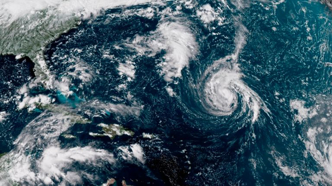
This enhanced satellite image made available by NOAA shows Tropical Storm Florence, center, in the Atlantic Ocean on Saturday afternoon (September 8, 2018). On Sunday morning the storm was upgraded to hurricane status. Credits: NOAA; AP.
NOAA forecasters lower Atlantic hurricane season prediction
Preparedness still key as more storms expected to develop
On Air: "NOAA's Updated 2018 Atlantic Hurricane Outlook," August 9, 2018 ... If you don't see the player above, it's because you're using a
non-Flash device (eg, iPhone or iPad). You can download the mp3 file by clicking here (mp3). It may take a few minutes to download, so please be patient.
New York, NY, September 10, 2018 - As reported by the National Oceanic and Atmospheric Administration (NOAA) during its revised Atlantic Hurricane Outlook last month (August 9th), which can be heard above, conditions in the ocean and the atmosphere are conspiring to produce a less active Atlantic hurricane season than initially predicted in May, though NOAA and FEMA are raising caution as the season enters its peak months.
“There are still more storms to come – the hurricane season is far from being over. We urge continued preparedness and vigilance,” said Gerry Bell, Ph.D., lead seasonal hurricane forecaster at NOAA’s Climate Prediction Center.
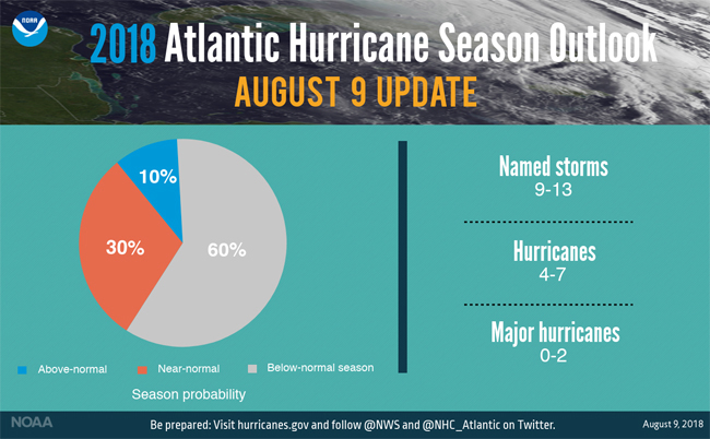
Seasonal forecasters with NOAA’s Climate Prediction Center have increased the likelihood of a below-normal Atlantic hurricane season to 60 percent (up from 25 percent in May) in the updated outlook. The likelihood of a near-normal season is now at 30 percent, and the chance of an above-normal season has dropped from 35 percent to 10 percent.

A summary graphic showing the updated Atlantic Hurricane Season forecast discussed in the press release. Credit: NOAA.
For the entire season, which ends November 30th, NOAA predicts a total of 9-13 named storms (winds of 39 mph or greater) of which 4-7 will become hurricanes (winds of 74 mph or greater), including 0-2 major hurricanes (winds of 111 mph or greater).
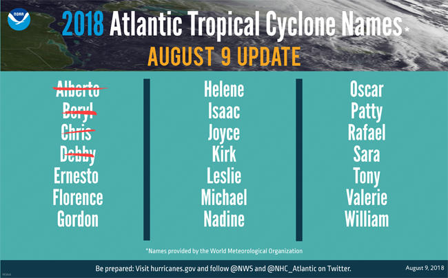
So far, the season has seen, as of August 9th, four named storms, including two hurricanes. An average six-month hurricane season produces 12 named storms, of which six become hurricanes, including three major hurricanes.
This outlook is for overall seasonal activity and is not a landfall forecast. Landfalls are largely determined by short-term weather patterns, which are only predictable within about one week of a storm potentially reaching a coastline.
To produce the seasonal update, forecasters take several factors into account. El Nino is now much more likely to develop with enough strength to suppress storm development during the latter part of the season. Today, NOAA’s Climate Prediction Center updated its forecast to a nearly 70 percent likelihood of El Nino during the hurricane season.

A graphic showing 2018 Atlantic tropical cyclone names selected by the World Meteorological Organization. So far this year we've seen Alberto, Beryl, Chris and Debby as named storms. Credit: NOAA.
Additionally, sea surface temperatures across the tropical Atlantic Ocean and Caribbean Sea have remained much cooler than average. A combination of stronger wind shear, drier air and increased stability of the atmosphere in the region where storms typically develop will further suppress hurricanes. Storm activity to-date and the most recent model predictions also contribute to this update.
“This updated outlook is a reminder that we are entering the height of hurricane season and everyone needs to know their true vulnerabilities to storms and storm surge,” said FEMA Administrator Brock Long. “Now is the time to know who issues evacuation orders in their community, heed the warnings, update your insurance and have a preparedness plan. Don’t let down your guard, late season storms are always a possibility, always keep your plans updated.”
NOAA also urges coastal residents to make sure they have their hurricane preparedness plans in place and to monitor the latest forecasts as we move into peak hurricane season.

PHOTO-GOES 16 image of hurricanes Katia, Irma and Jose captured September 8, 2017. Credit: NOAA.
Harvey, Irma, Maria and Nate are storm names that don’t bear repeating.
Due to the extensive damage caused in the United States and Caribbean in 2017, the World Meteorological Organization’s Region IV Hurricane Committee officially retired these names this past April.
Storm names are retired if they were so deadly or destructive that the future use of the name would be insensitive - otherwise names are reused on a six-year cycle.
The committee also selected the replacement names for Harvey, Irma, Maria and Nate with Harold, Idalia, Margot, and Nigel respectively that will first appear in the 2023 list of storm names.
Including these four additions, there have been 86 names retired from the Atlantic basin list since 1954, when storms began to be named. The 2005 hurricane season has the most retired names (five) for one season.

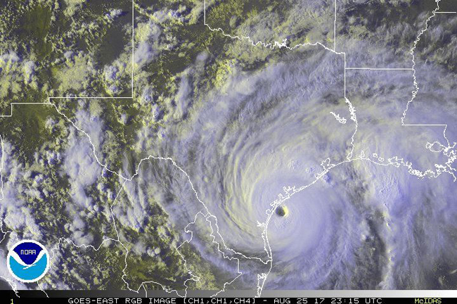
Hurricane Harvey near Landfall between Port Aransas and Port O'Connor, Texas on August 25, 2017. Credit: NOAA.
Last year was the seventh most active season in the historical record dating to 1851 and was the most active season since 2005.
The 2017 season produced 17 named storms of which 10 became hurricanes including six major hurricanes (Category 3, 4 or 5) – including the first two major hurricanes to hit the continental U.S. in 12 years.
Three devastating major hurricanes made landfall (Harvey in Texas; Irma in the Caribbean and southeastern U.S.; and Maria in the Caribbean and Puerto Rico). Harvey was also the first major hurricane to hit the U.S. since Wilma struck Florida in October 2005.
Additionally, four other storms hit the U.S., including Cindy in Texas, Emily and Phillipe in Florida, and Nate in Mississippi.
Though 2017 was a furious season, NOAA issued early and reliable forecasts to communities in the path of this year’s storms. NOAA's preliminary data showed that the National Hurricane Center issued forecasts with record-setting accuracy. And track forecasts for the three most damaging hurricanes were about 25 percent more accurate than average.
More Info: NOAA and New York Sea Grant
NOAA's mission is to understand and predict changes in the Earth's environment, from the depths of the ocean to the surface of the sun, and to conserve and manage our coastal and marine resources. Join NOAA on Twitter, Facebook, Instagram and our other social media channels.
New York Sea Grant (NYSG), a cooperative program of Cornell University
and the State University of New York (SUNY), is one of 33 university-based
programs under the National Oceanic and Atmospheric Administration’s
National Sea Grant College Program.
Since 1971, NYSG has represented a statewide network of integrated
research, education and extension services promoting coastal community
economic vitality, environmental sustainability and citizen awareness
and understanding about the State’s marine and Great Lakes resources.
Through NYSG’s efforts, the combined talents of university scientists
and extension specialists help develop and transfer science-based
information to many coastal user groups—businesses and industries,
federal, state and local government decision-makers and agency managers,
educators, the media and the interested public.
The program maintains Great Lakes offices at Cornell University, SUNY
Buffalo, SUNY Oswego and the Wayne County Cooperative Extension office
in Newark. In the State's marine waters, NYSG has offices at Stony Brook
University in Long Island, Brooklyn College and Cornell Cooperative
Extension in NYC and Kingston in the Hudson Valley.
For updates on Sea Grant activities: www.nyseagrant.org has RSS, Facebook, Twitter, and YouTube links. NYSG offers a free e-list sign up via www.nyseagrant.org/nycoastlines for its flagship publication, NY Coastlines/Currents, which is published quarterly. Our program also produces an occasional e-newsletter,"NOAA Sea Grant's Social Media Review," via its blog, www.nyseagrant.org/blog.