"North Pond Resiliency Project" Project: A collection of aerial imagery shows the damage caused by high water at North Sandy Pond and eastern Lake Ontario. Among them is damage to the Greene Point Marina, Sandy Creek, changes to the pond's inlet, and erosion of critical dunes. Credit: Watertown Daily Times.
Aerial photos help researchers assess changes along Lake Ontario shoreline, North Sandy Pond
— Gordon Block, Watertown Daily Times
Sandy Creek, NY, June 25, 2017 — High above Lake Ontario, researchers Thomas Hart and Geoffrey Steadman have taken notes, captured images and assessed the shoreline below.
The insights from their flights and ground-level analysis may help show the changes to the shoreline around North Sandy Pond, and how officials can manage the lake’s shoreline.
“People will say the lake will do what they want to do, and in some ways they’re right,” Mr. Hart said. “But I think studying an area like this which hasn’t had a study like this before, any information allows us to be better decision makers of how we dedicate our efforts and resources.”
The pair, who first worked together in the late 1980s on state-funded research of the lake, are currently nearing the end of a two-year study to assess conditions in the pond area.
Their research covers an approximately four-mile stretch of shoreline from just south of Sandy Island Beach State Park up to Cranberry Pond in Mannsville.
In addition to collecting aerial imagery across the lake, most recently on June 12, and digital maps representing several years, the pair will look to assess sand buildup in the pond’s shore area, including areas like Carl Island.
“Can we use that to tell us what’s going to happen in the future, and to plan for that?” said Mr. Steadman.
One area of change at North Sandy Pond has been its inlet, which Mr. Hart said has changed locations multiple times in about the last century.
“The main question is what effort do you make to keep the inlet the way it is, and what happens when new inlets form?” he said.
The pair noted their work is just the latest in decades of research along the shore, which has been paired with efforts from environmental groups like the Eastern Lake Ontario Dune Coalition and the Ontario Dune Coalition to help conserve sand dune, wetland, and barrier beach resources and related wildlife. Among the successes noted by the researchers was the development of Sandy Island Beach State Park.
“We all want to manage it so wildlife and people can coexist, and in some ways we’ve been pretty successful,” Mr. Hart said.
The pair hope to release the findings of their latest work within the next few months.
“We have to get this information to people that aren’t technical, and it explain to the public at large,” Mr. Hart said.
The pair’s work is supported by a $25,000 Great Lakes Basin Small Grant to the Oswego County Soil and Water Conservation District. The grant is backed by the state Environmental Protection Fund and Environmental Conservation Program, and was announced by the state Department of Environmental Conservation and New York Sea Grant.
In Photos: North Pond Resiliency Project
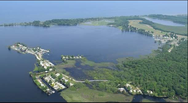
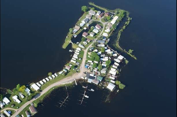
Aerial views of Greene Point Marina in Sandy Creek and the Brennans Bay RV Park in Mannsville on June 12 show high water levels from Lake Ontario and subsequent flood damage.Credit (all photos): Geoff Steadman and Thomas Hart
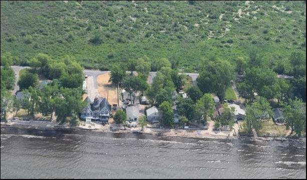
The shoreline of Jefferson Park, Ellisburg, which sits on Lake Ontario, on June 12. The high water levels have threatened homes and businesses across the lake.
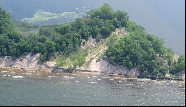
An aerial view of the high dunes on the North Pond coastal barrier on June 12, which are described as the largest in New York and the second largest in the northeastern United States. High water levels on Lake Ontario are eroding the dunes, according to researchers.
An image of Greene Point Marina from the air on June 12 shows docks under water and yards submerged.
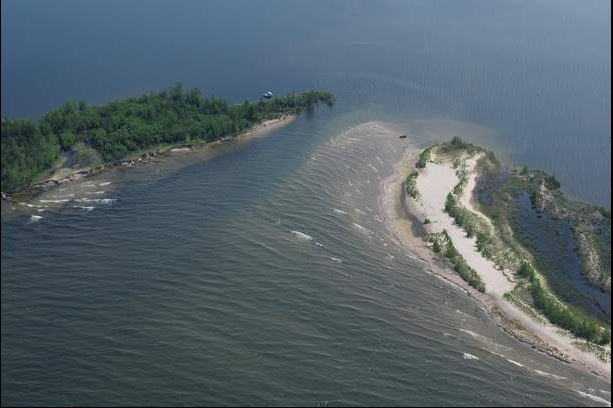
An aerial view of the North Pond Inlet on June 12, with water covering the sand flat at the north end of the south barrier spit and also covering part of the vegetated barrier.
More Info: New York Sea Grant
New York Sea Grant (NYSG), a cooperative program of Cornell University
and the State University of New York (SUNY), is one of 33 university-based
programs under the National Oceanic and Atmospheric Administration’s
National Sea Grant College Program.
Since 1971, NYSG has represented a statewide network of integrated
research, education and extension services promoting coastal community
economic vitality, environmental sustainability and citizen awareness
and understanding about the State’s marine and Great Lakes resources.
Through NYSG’s efforts, the combined talents of university scientists
and extension specialists help develop and transfer science-based
information to many coastal user groups—businesses and industries,
federal, state and local government decision-makers and agency managers,
educators, the media and the interested public.
The program maintains Great Lakes offices at Cornell University, SUNY
Buffalo, SUNY Oswego and the Wayne County Cooperative Extension office
in Newark. In the State's marine waters, NYSG has offices at Stony Brook
University in Long Island, Brooklyn College and Cornell Cooperative
Extension in NYC and Kingston in the Hudson Valley.
For updates on Sea Grant activities: www.nyseagrant.org has RSS, Facebook, Twitter, and YouTube links. NYSG offers a free e-list sign up via www.nyseagrant.org/nycoastlines for its flagship publication, NY Coastlines/Currents, which is published quarterly. Our program also produces an occasional e-newsletter,"NOAA Sea Grant's Social Media Review," via its blog, www.nyseagrant.org/blog.