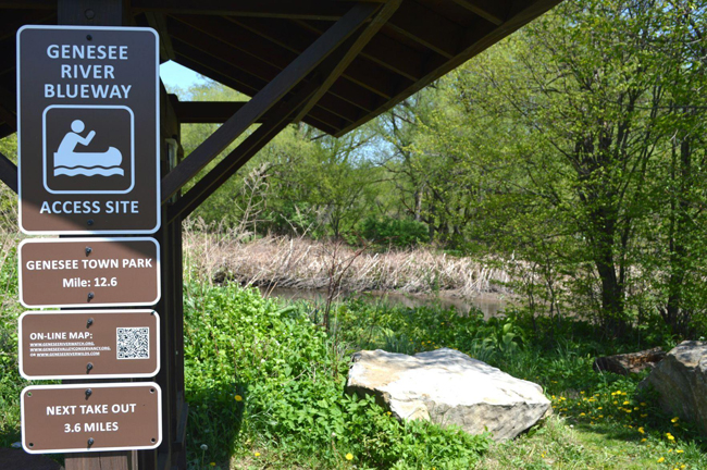
A series of signs on the Genesee River in Allegany County marks access points — and miles between access points — for river paddlers. Credit: Kathryn Ross/Olean Times Herald
NOTE: This effort is related to a 2017-18 Great Lakes small grant funded through New York Sea Grant and the NYS Department of Environmental Conservation. The project was led by the Genesee RiverWatch. More on that and other projects in the series at "NYSDEC and NY Sea Grant Announce $199,575 in Grants for Great Lakes Basin Projects."
— Filed by Kathryn Ross for the Olean Times Herald
Wellsville, NY, May 22, 2021 - Before there were highways, people found their way into the wilderness by following the rivers. The Genesee River was one of the main thoroughfares travelled by Indigenous People and European explorers and settlers alike.
Today, a journey by kayak or canoe is easier than ever thanks to the work of the Genesee River Wilds group.
Along with its 18 river access sites, which allow easy put-ins and take-outs for river paddlers, they now have a way to tell exactly where they are on the river and where the next access point is located.
Genesee River Wilds president Thomas Rhett said river ramblers will find mile markers and reflective signs along the riverbank to help guide them on their river floats.
The new signs were installed late in 2020 from Pennsylvania to Portageville.
“This was a great project with the help of Genesee RiverWatch to make our river safer and more accessible,” Rhett said. “By adding mile markers and reflective signs that are visible from the water, people can now confidently see where and when they should be getting off the river.”
The sign project was part of the Genesee River becoming part of a Genesee River Blueway Map, which is now available.
Blueways, Rhett explained, are river trails. “Blueway is a generic term that is used to indicate a river trail that people can navigate.”
By looking for the Genesee Blueway map on the Genesee RiverWatch website, enthusiasts can find a downloadable map which displays current river access locations from Pennsylvania through Allegany County, all the way to Lake Ontario. A web-based Interactive Map gives users detailed information about each access point, including photos of the sites. There's also a downloadable overview map.
Genesee RiverWatch partnered with the Genesee Valley Conservancy and Genesee River Wilds to update the Genesee River Blueway Trail Map. The project was funded by a $25,000 New York Sea Grant and had the support of the Greater Allegany County Chamber of Commerce.
Rhett said Genesee River Wilds has big plans for expanding the use of the Genesee River and the trails that follow its banks.
“With a Ralph Wilson grant we want to connect the Greenway Trail in Belfast to the WAG Trail in Wellsville, which leads to Genesee, Pa., in the hope of revitalizing the economies of the blueway trail towns,” he said.
The long-term plan of Genesee River Wilds is its Triple Divide trail system that will link the Genesee Valley Greenway via the WAG Trail with the Pine Creek Trail in Pennsylvania to become the centerpiece of a unique recreational corridor that will run from Rochester to Williamsport, Pa. The trail will facilitate bikers, hikers and those navigating the rivers.
Genesee River Wilds is dedicated to restoring, protecting and enjoying the upper Genesee River For more information go to www.geneseeriverwilds.com or look for it on Facebook.
More Info: New York Sea Grant
New York Sea Grant (NYSG), a cooperative program of Cornell University
and the State University of New York (SUNY), is one of 34 university-based
programs under the National Oceanic and Atmospheric Administration’s
National Sea Grant College Program.
Since 1971, NYSG has represented a statewide network of integrated
research, education and extension services promoting coastal community
economic vitality, environmental sustainability and citizen awareness
and understanding about the State’s marine and Great Lakes resources.
Through NYSG’s efforts, the combined talents of university scientists
and extension specialists help develop and transfer science-based
information to many coastal user groups—businesses and industries,
federal, state and local government decision-makers and agency managers,
educators, the media and the interested public.
The program maintains Great Lakes offices at Cornell University, SUNY
Buffalo, SUNY Oswego and the Wayne County Cooperative Extension office
in Newark. In the State's marine waters, NYSG has offices at Stony Brook
University in Long Island, Brooklyn College and Cornell Cooperative
Extension in NYC and Kingston in the Hudson Valley.
For updates on Sea Grant activities: www.nyseagrant.org has RSS, Facebook, Twitter, Instagram, and YouTube links. NYSG offers a free e-list sign up via www.nyseagrant.org/nycoastlines for its flagship publication, NY Coastlines/Currents, which is published quarterly.