Syracuse, NY, March 19, 2015 - We're all used to big snow storms, but, as WSYR Channel 9 ABC-affiliate's Syracuse station reports, when you hear that a storm is heading our way, its hard to determine how much damage it will cause, both environmentally and financially.
Oswego County researchers are trying to change that by developing a system that tracks and monitors storm patterns in the Great Lakes. The goal is to better prepare Central New Yorkers when big storms hit.
As they look at the eastern shores of Lake Ontario -- researchers with New York Sea Grant want to find out what's below the ice? Is there erosion or structural damage?
"Our aim is to better determine when and how these storms happen and how we can be better prepared for them," says David White, New York Sea Grant's coastal recreation and tourism specialist.
The project focuses on the dunes along Lake Ontario in Oswego County and on the Sodus Bay area in Wayne County.
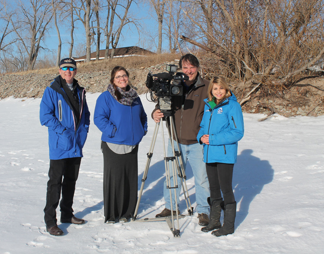
New York Sea Grant Recreation and Tourism Specialist Dave White, left, and New York Sea Grant Coastal Community Development Specialist Mary Penney recently met News Channel 9 Reporter Rachel Polansky and Photojournalist Bill Goldschmidt at Sandy Island Beach State Park for a story on the NYSG Tracking Great Lakes Nor’easters Project. The project has nearly $80,000 for a two-year study of how storms on Lake Ontario impact environmental and manmade resources in the Sodus Bay area and along the Eastern Lake Ontario Dunes and Wetlands area. Photo: Kara Lynn Dunn
"Out here on the lakeshore, you can have 30, 40, 50 mile-per-hour winds that can have a significant impact, if you're not prepared," says White.
Just how significant an impact, though, researchers don't know. That's why they're reviewing data, maps, and reports on previous Great Lakes storms -- some dating back to 1950. They're also developing a photo monitoring program. Each year, a person will come out to each designated location along Lake Ontario, and they'll take a photo. Over time, researchers will be able to compare these photos, to see what's changed or what's remained the same.
The project's investigators will create a database of Great Lakes storms. And if there's a storm that fits a specific pattern, researchers hope they'll recognize it a few days before the storm hits. Then, they can relay that information to nearby neighbors and businesses.
"At the end, its gonna be about what they need. And we can provide them a research and outreach team, to put together some of those answers," says White.
New York Sea Grant received $80,000 worth of funding from the National Oceanic and Atmospheric Administration for this two-year project.
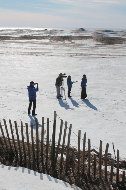
PHOTO: New York Sea Grant Recreation and Tourism Specialist Dave White captures a photo as New York Sea Grant Coastal Community Development Specialist Mary Penney is interviewed by News Channel 9 Reporter Rachel Polansky and Photojournalist Bill Goldschmidt. The background shows frozen ice dunes along the eastern Lake Ontario shoreline. Photo: Kara Lynn Dunn
More Info:
NOAA/Sea Grant's Coastal Storms Funding
Funding for this effort comes through a "Special Projects Funding
Announcement" released in April 2014 by NOAA's Coastal Storms Program
and the National Sea Grant College Program. The funding—up to $64,000 in
total federal monies—is being used through August 2016 to support
program development within the Great Lakes Sea Grant Network in the area
of hazards and coastal storm resilience.
In a separate coastal storms effort, New York Sea Grant, Connecticut Sea
Grant and New Jersey Sea Grant were awarded $1.4 million in funding in
January 2014 via NOAA to 10 social science research projects to improve
community understanding and response to coastal storm hazard information
as part of the NOAA Sea Grant Coastal Storm Awareness Program (CSAP).
The findings from the program's projects are intended to raise awareness
of how severe weather is communicated to and within communities.
Additional information on CSAP can be found at www.nyseagrant.org/csap.
NOAA
NOAA's mission is to understand and predict changes in the Earth's
environment, from the depths of the ocean to the surface of the sun, and
to conserve and manage our coastal and marine resources. Join NOAA on Twitter, Facebook and our other social media channels and visit the organization's news release archive.
New York Sea Grant
New York Sea Grant (NYSG), a cooperative program of Cornell University
and the State University of New York, is one of 33 university-based
programs under the National Sea Grant College Program (NSGCP) of the
National Oceanic and Atmospheric Administration (NOAA). The NSGCP
engages this network of the nation’s top universities in conducting
scientific research, education, training and extension projects designed
to foster science-based decisions about the use and conservation of our
aquatic resources. Through its statewide network of integrated
services, NYSG has been promoting coastal vitality, environmental
sustainability, and citizen awareness about the State’s marine and Great
Lakes resources since 1971.
For updates on Sea Grant activities: www.nyseagrant.org has RSS, Facebook, Twitter, and YouTube links. NYSG also offers a free e-list sign up via www.nyseagrant.org/coastlines for its flagship publication, NY Coastlines/Currents, which is published several times a year.