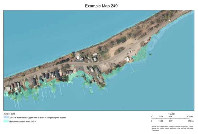
This sample map was generated using the New York Sea Grant Web Mapping Tool and shows inundation (249 feet) of the mapped location. Credit: New York Sea Grant
Tutorial Webinar Planned for June 20th
Contacts:
Mary Austerman, Great Lakes Coastal Community Specialist, P: 315-331-8415, E: mp357@cornell.edu
Kara Lynn Dunn, NYSG Great Lakes Publicist, E: karalynn@gisco.net, P: 315.465.7578
Newark, NY, June 6, 2019 - New York Sea Grant, with funding from the National Oceanic and Atmospheric Administration, has developed new interactive inundation mapping tools to help property owners along Lake Ontario and its embayments enhance flooding preparedness.
The tools are online with a tutorial to assist users. You can register for a free, 45-minute training webinar that is scheduled for June 20th at 1 p.m.
The online mapping tools provide users with a parcel-level view of areas that could experience flooding along Lake Ontario and its embayments based on predetermined water levels and digital elevation data. Wayne and Monroe County stakeholders beta-tested the new tools. The future scenarios used in the mapping tools are not water levels currently projected, but potential lake levels offered for planning purposes only.
“These new mapping tools will allow users to visualize inundation information for individual parcels of interest using the predetermined water levels. That information can be used by individual property owners as well as communities to enhance flood preparedness and planning going forward,” said project leader and New York Sea Grant Coastal Community Development Specialist Mary Austerman, Newark, N.Y.
Use of the mapping tools has been designed to assist planning, e.g., location and triage of accessory structures and belongings during high water, to inform community-level preparedness planning, and to help identify areas that warrant in-depth analyses, enhanced flood response, or policy development to enhance flood resilience.
Austerman and Jessica Kuonen, a Coastal Community Development Assistant with New York Sea Grant, are the developers of the Lake Ontario Inundation Map Package and Lake Ontario Inundation WebMap tools. These new mapping tools were developed as part of a larger project creating a Coastal Resiliency Index, due out later this year. A similar mapping tool for Lake Erie is being explored. For more information, contact Mary Austerman, New York Sea Grant, 315-331-8415 ext 121, mp357@cornell.edu.
For additional information on NYSG’s Great Lakes Coastal Communities extension efforts, visit www.nyseagrant.org/ccd.
More Info: New York Sea Grant
New York Sea Grant (NYSG), a cooperative program of Cornell University
and the State University of New York (SUNY), is one of 33 university-based
programs under the National Oceanic and Atmospheric Administration’s
National Sea Grant College Program.
Since 1971, NYSG has represented a statewide network of integrated
research, education and extension services promoting coastal community
economic vitality, environmental sustainability and citizen awareness
and understanding about the State’s marine and Great Lakes resources.
Through NYSG’s efforts, the combined talents of university scientists
and extension specialists help develop and transfer science-based
information to many coastal user groups—businesses and industries,
federal, state and local government decision-makers and agency managers,
educators, the media and the interested public.
The program maintains Great Lakes offices at Cornell University, SUNY
Buffalo, SUNY Oswego and the Wayne County Cooperative Extension office
in Newark. In the State's marine waters, NYSG has offices at Stony Brook
University in Long Island, Brooklyn College and Cornell Cooperative
Extension in NYC and Kingston in the Hudson Valley.
For updates on Sea Grant activities: www.nyseagrant.org has RSS, Facebook, Twitter, and YouTube links. NYSG offers a free e-list sign up via www.nyseagrant.org/nycoastlines for its flagship publication, NY Coastlines/Currents, which is published quarterly. Our program also produces an occasional e-newsletter,"NOAA Sea Grant's Social Media Review," via its blog, www.nyseagrant.org/blog.