The New York’s Great Lakes Coastal Resilience Index
The New York’s Great Lakes Coastal Resilience Index (CRI) is a self-assessment tool developed by New York Sea Grant. To complete the index, community leaders get together and use the tool to guide discussion about their community’s resilience to coastal hazards. The Index provides a simple, inexpensive method for community leaders to perform a self-assessment of their community’s resilience to coastal flooding and weather disasters, identifying weaknesses a community may want to address prior to the next hazard event and guiding community discussion. The Index is not intended for comparison between communities.
The Index uses information that is readily available and asks mainly "yes" or "no" questions. It consists of a 9-page exercise to investigate the vulnerabilities across six community sectors (critical facilities and infrastructure, transportation issues, community plans and agreements, mitigation measures, business plans, and social systems). The booklet also includes 24-pages of coastal flood mapping tutorials, and weather disaster narratives and charts to help frame the exercise. The Index can be completed in approximately three hours.
Click here to download the 44-page CRI in PDF format.
For assistance with this Index, contact Mary Austerman at 315-331-8415 or mp357@cornell.edu.
Inundation Mapping Tools
These tools and tutorials were developed to be used with an associated Coastal Resilience Index, but can also be used as standalone products. These map tools overlay inundation at different lake levels to bring awareness to infrastructure and services that may be at risk. Inundation layers were created using a bathtub method and are based on the elevation of static water using the highest quality elevation data available for each county. Currently wave run up data are not readily available. As a result, the generated maps assume only flat water associated with lake levels, not stormwater drainage issues.
Features:
• Mapping tools and tutorials available in two different formats: Web mapping application for anyone with an internet connection. Map package for advanced GIS users.
• View parcels and infrastructure at high resolution
• Create maps. Export in PDF format.
Lake Ontario Tools:
• Lake Ontario Web Mapping Application (Non-ArcGIS users click here)
For instructions, see Lake Ontario Mapping Application Tutorial (pdf)
• Lake Ontario Map Package (ArcGIS users click here) ArcMap Desktop version 10.0 or higher is required
For instructions see the Lake Ontario Map Package Tutorial (pdf)
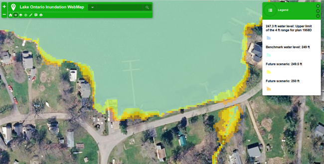
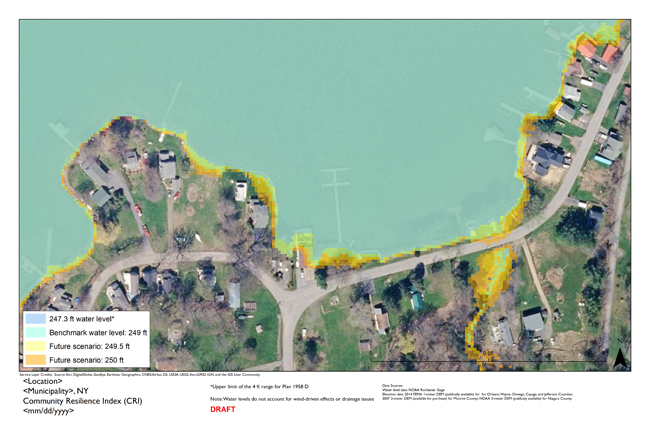 Disclaimer: The data and maps in these tools illustrate the scale of potential flooding or land exposure at a given water level, not the exact location. They do not account for erosion, subsidence, or future construction. Water levels are shown as they would appear during calm conditions (excludes wind-driven changes in water levels). The data, maps, and information provided should be used only as a screening-level tool for management decisions. As with all remotely sensed data, all features should be verified with a site visit. The data and maps in these tools are provided “as is,” without warranty to their performance, merchantable state, or fitness for any particular purpose. The entire risk associated with the results and performance of these data is assumed by the user. These tools should be used strictly as a planning reference tool and not for navigation, permitting, or other legal purposes.