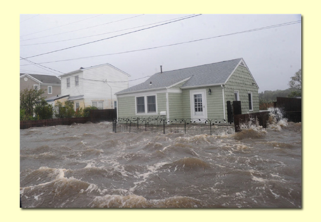
Photograph depicting storm surge damage from Hurricane Irene in August 2011, used in the photograph experimental condition. Credit: Laura Rickard.
— By Chris Gonzales, Communications Specialist, New York Sea Grant
New York, NY, April 23, 2018 - People who were shown a hypothetical hurricane forecast accompanied by a photograph of a house immersed in turbulent floodwaters were more likely to mention evacuation as an option than did those shown a forecast in writing or a map of projected storm surge.
Using evocative photos or artwork may be preferable to a map or text alone … as long as audiences don’t freak out, say scientists funded through the National Oceanic and Atmospheric Administration (NOAA), as part of the Sea Grant-administered Coastal Storm Awareness Program (CSAP).
Hurricane Sandy produced storm surge levels between three and nine feet above ground level from Georgia to Maine when it hit in late October 2012. It caused over $50 billion in damages and claimed 147 lives, despite official warnings of the danger.
Researchers are thinking about the communication challenge of how to influence people’s decisions of whether to stay or go. One distinction they make is between “iconic” images such as abstract maps, and “indexical” images, such as a photograph of a particular blue Cape Cod–style house with four feet of churning gray water lashing against its foundation.
Mass media broadcasters tend to display forecast maps, perhaps because of their ease of availability under tight deadlines, and their intuitive clarity to meteorologists and other experts.
But researchers are wondering if the maps might be too abstract to convey the urgent message: “Get out! Your life is in danger!”
As detailed in a recent paper published in Risk Analysis, a scholarly journal, Laura Rickard (Department of Communication and Journalism at the University of Maine, Orono, and formerly of the State University of New York College of Environmental Science and Forestry) and colleagues implemented a large-scale survey with over 600 respondents who were residents of New York, New Jersey, and Connecticut, asking them to respond to simulated hurricane warnings.
“Scientific information, such as a cancer diagnosis or an approaching hurricane, represents abstract ideas,” her team writes. “Possible outcomes may be unobservable in a physical sense.”
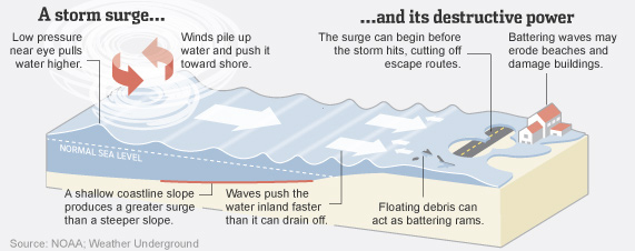
According to NOAA, a storm surge is the rise of water driven toward shore by storm winds, over and above predicted tide levels. Storm-surge flooding varies widely, depending on the height of terrain along local coastlines.
Recent research suggests that certain visuals, such as infographics, can make messages related to environmental issues more compelling, such as bolstering or depressing feelings of self-efficacy in adapting behaviors to climate change.
Rickard and colleagues expected audiences would respond more acutely to the photograph condition, and they were right. Interestingly, the team found a moderating effect of hurricane-related experience – e.g., having been in a hurricane before – on survey respondents’ hurricane risk perceptions. Specifically, for those who reported little or no past experience, viewing a photograph engendered significantly higher perceptions of risk than viewing a map or no visual at all, but the same contingent effect was not true of those with more experience.
The scientists also found that hurricane-related experience did not reduce the effect of seeing the photograph on mentioning the option to evacuate.
In their report, the researchers wondered whether publicizing images of the previous storm “could also conjure distressing feelings or memories” – a possible ethical implication – and called for further study of more urgent-seeming messages. According to Dr. Rickard, “This research extends what scholars have shown about the persuasiveness of visuals in other contexts, such as health communication, to the realm of weather and natural hazards and offers guidance on how we might craft preventive messages.”
As many people—professionals and non-experts alike—find themselves thinking about severe weather and alert messaging systems, one thing is clear: environmental awareness and the implications of severe weather have become a new circumstance of our modern lives. This new research sheds light on how we can design warning messages in order to save lives.
References
Laura N. Rickard, et al.(2017) The Proof is in the Picture: The Influence of Imagery and Experience in Perceptions of Hurricane Messaging. Weather, Climate, and Society. 7, 471-485 DOI: 10.1175/WCAS-D-16-0048.1
More Info: NOAA Sea Grant's Coastal Storm Awareness Program
The 4-1/2 minute trailer for NOAA Sea Grant's Coastal Storm Awareness Program's 23-minute documentary, view-able on YouTube.
Hurricane Sandy traveled up the Atlantic coast in late October 2012,
coming ashore as a "Superstorm" in the tri-state region. While
evacuation orders were in place, there was still significant loss of
life in flooded homes. Why didn’t or couldn’t people leave for safe
shelter?
Answering this question was at the heart of the $1.8M National Oceanic
and Atmospheric Administration-funded Coastal Storm Awareness Program
(CSAP), a series of 2014-15 social science studies administered by Sea
Grant programs in New York, New Jersey and Connecticut. Findings from
CSAP-funded investigators are shared in a 23-minute documentary short
and accompanying four-and-a-half minute trailer, which were released in
May 2016.
The goal of this suite of 10 research projects – which were
competitively funded at institutions from Yale University to Mississippi
State University via Sandy Supplemental funds appropriated by Congress
under the Disaster Relief Appropriations Act of 2013 – was to better
understand how people react to storm warnings and make the decision to
stay or to go.
For more, see www.nyseagrant.org/csap.
More Info: New York Sea Grant
New York Sea Grant (NYSG), a cooperative program of Cornell University
and the State University of New York (SUNY), is one of 33 university-based
programs under the National Oceanic and Atmospheric Administration’s
National Sea Grant College Program.
Since 1971, NYSG has represented a statewide network of integrated
research, education and extension services promoting coastal community
economic vitality, environmental sustainability and citizen awareness
and understanding about the State’s marine and Great Lakes resources.
Through NYSG’s efforts, the combined talents of university scientists
and extension specialists help develop and transfer science-based
information to many coastal user groups—businesses and industries,
federal, state and local government decision-makers and agency managers,
educators, the media and the interested public.
The program maintains Great Lakes offices at Cornell University, SUNY
Buffalo, SUNY Oswego and the Wayne County Cooperative Extension office
in Newark. In the State's marine waters, NYSG has offices at Stony Brook
University in Long Island, Brooklyn College and Cornell Cooperative
Extension in NYC and Kingston in the Hudson Valley.
For updates on Sea Grant activities: www.nyseagrant.org has RSS, Facebook, Twitter, and YouTube links. NYSG produces a monthly e-newsletter, "NOAA Sea Grant's Social Media Review," via its blog, www.nyseagrant.org/blog. Our program also offers a free e-list sign up via www.nyseagrant.org/coastlines for its flagship publication, NY Coastlines/Currents, which is published quarterly.