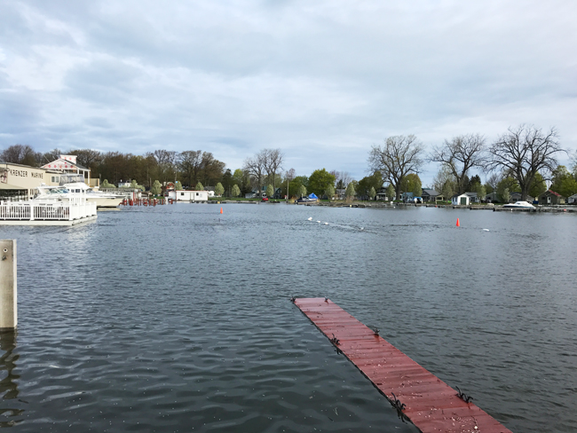
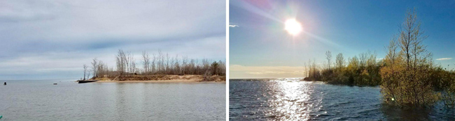
High water levels in Sodus Bay. Credit: Mary Austerman/NYSG
New York Sea Grant funds a rapid response Cornell University community-based project
Contacts:
Mary Austerman, Great Lakes Coastal Community Development Specialist, New York Sea Grant, P: 315-331-8415, E: mp357@cornell.edu
Kara Lynn Dunn, Publicist, P: 315-465-7578, E: karalynn@gisco.net
RELATED: In Photos: St. Lawrence River Property Owners Sought for High Water Impact Survey More>>
Ithaca, NY, May 25, 2017 - Respondents are needed for a just-funded New York Sea Grant rapid response project wherein Cornell University investigators will develop and conduct a standardized high water impact survey in the areas along southern and eastern Lake Ontario.
This effort is in response to stakeholder requests for a standardized method to collect data on the impacts of high water levels on waterfront properties.
The information collected will be used to identify areas that are most vulnerable to high water levels in the future and to inform future community flood risk planning.
The survey was pilot tested in the Sodus Bay area of Wayne County, NY, and will be made available through municipality email lists and New York Sea Grant social media to property owners in communities along southern and eastern Lake Ontario. Survey responses will be accepted through August 31, 2017.
The project leaders are New York Sea Grant Coastal Community Development Specialist Mary Austerman, Cornell University Assistant Professor of Biological and Environmental Engineering Dr. Scott Steinschneider, and Cornell University Professor of Natural Resources Dr. Richard C. Stedman.
Anyone interested in taking the survey may access it HERE or contact Mary Austerman at 315-331-8415 or mp357@cornell.edu.
New York Sea Grant is also developing a specific survey for the St. Lawrence River region.
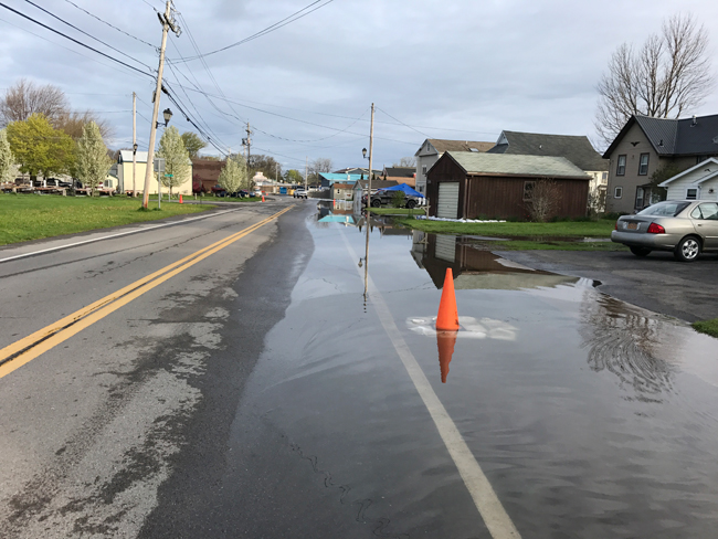
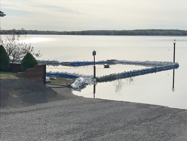
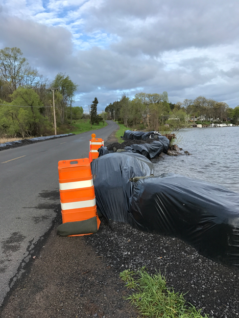
In Photos: High water levels in Sodus Bay
Credit: Mary Austerman/NYSG
Credit: Mary Austerman/NYSG
Credit: Mary Austerman/NYSG
On YouTube: NY Sea Grant Hopes to Survey Flood Damage
Jefferson County, NY, May 22, 2017 - Oftentimes when a major storm hits a community, it comes and goes. The damage is obvious, but people can soon begin the process of recovery.
But, as Northern NY's Spectrum News reporter Brian Dwyer reports, that isn't the case with Lake Ontario's flooding. We're still feeling the effects of weather conditions dating back to the fall, and water levels may not be back to normal until this coming fall.
That makes it very hard to track the financial damage and study the reasons why some infrastructure failed.
New York Sea Grant is planning to fund, develop, test and eventually distribute a survey that will assess and report the impact high waters have had. But because the flooding isn't over and waters won't recede for some time, it could be a while before it can get going.
"This is the event without a storm, but it's an event of all of the storms. It's going to continue to have an impact. That makes it very uniquely different for people in that the water didn't rise and fall, and then we go back to business as usual and get things cleaned up," said Dave White of New York Sea Grant.
Now some money is already headed the shoreline's way. Governor Andrew Cuomo announced Monday morning that communities affected by flooding can share a $10 million pot to fix roads, walls, water and sewer infrastructure and more.
On Air: Environmental damage from Lake Ontario flooding could be permanent
Lake Ontario's historic levels are threatening residents and the environment as well, engulfing the north side of the Sandy Pond sand dune. The photo on the left was taken on April 3 and the photo on the right was taken on May 13. Photos: Cathy Goodnaugh/WRVO Radio
This audio clip is from a discussion on WRVO radio. Based in Oswego NY, WRVO 89.9 FM is a part of the National Public Radio digital network. If you don't see the player above, it's because you're using a non-Flash device (eg, iPhone or iPad). You can download the mp3 file by clicking here (mp3). It may take a few minutes to download, so please be patient.
Oswego, NY, May 22, 2017 - Lake Ontario is now 33 inches above its long-term average and it's not yet at its peak. That sustained flooding is threatening residents along the shorelines and scientists say it is also taking a toll on the environment.
As New York Sea Grant's Dave White tells reporter Payne Horning from SUNY Oswego-based WRVO Radio, some of the flooding damage from what he calls a several-months-long weather event will be permanent, but it's difficult to know just how profound the impact is on the environment until the water recedes. He says it's like waiting for morning to come after a storm blows through in the night.
"We're going to wait for the light but the light is not going to come for several weeks to several months to potentially several years," White said.
Some environmental damage is already on full display. The fresh water sand dunes along Oswego and Jefferson counties that support several ecosystems are being washed away and in some places completely overtaken. That's bad news for residents too because these strips of land act as a natural barrier between the shoreline and Lake Ontario.
Sandy Creek resident Rob Tackney has been watching the water engulf Sandy Pond's barriers for weeks.
"It takes out those sand dunes over there and I'll tell you what -- a whole new game now because we're now on the open lake," Tackney said.
The north side of the Sandy Pond sand dune is now under water. White says the breaching like that has not happened in four decades and it could take years to repair them.
"And the longer this goes and the more storm generated wave you have, those breaches are becoming wider and deeper and basically forming new channels and that becomes a concern that you have multiple channels on bays that may have only had one more before what is that impact ecologically, environmentally and economically to those areas," White said.
White is referring to the ecosystems that rely on shore, wetlands and sand dunes, which are now flooded.
"We have lost entire beach area it's now cutting into the dune area that takes years to rebuild that many of those areas will need to be re-vegetated those are areas that are extremely common and popular for migrating birds and other wildlife," he said.
A spokesperson for the Oswego County Emergency Management Office says the disintegrating sand dunes in Sandy Pond are one of its concerns and they are monitoring the situation.
On Air: Waterfront Businesses Face Significant Impact from Lake Ontario Flooding
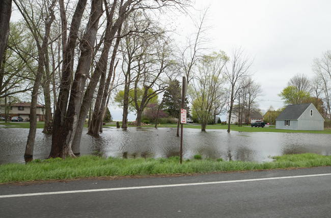
Lake flooding near Rochester last month. Photo: Gov. Cuomo's flickr page
Syracuse, NY, May 17, 2017 - The rain may have stopped, but water levels continue to rise on Lake Ontario, the St. Lawrence River, and the Salmon River. There’s growing concern about damage to waterfront businesses as the busy summer boating and recreation season gets underway.
Long-time Oswego County residents like Dave White and Janet Clerkin say these water levels are unprecedented.
"I've been with New York Sea Grant for over 30 years, so I've been through the past high-highs and the past low-lows as some refer to it," White, a New York Sea Grant specialist, told WAER 88.3 FM reporter Scott Willis. "Obviously what is occurring right now is well beyond what any of us have been through or could have imagined."
Clerkin is Oswego County’s tourism and public information coordinator. She's lived in the area for three decades.
"We haven't see anything like this with this amount of shoreline damage and high water levels."
She says several marinas and boat launches have been impacted and are closed due to high water levels.
"So that is definitely impacting the fishing charters in those areas," Clerkin said. "People are still fishing out of Oswego, and fishing on the lake is very strong right now. But the high water level is impacting the ability of boats to get in and out. Also there is a lot of debris in the waterways."
Clerkin says the impact and damage varies widely, so there’s still plenty to do in unaffected areas. New York Sea Grant Recreation Specialist Dave White agrees. That’s why he suggests planning ahead…
"The lake's open for business. It's a large resource. But as individuals we a really need to take that next step...we might have to change the boat launch ramp that we normally used. Or, we might have to talk to our marina operator, when do you think might you be able to get my boat in. Depending on the structure of the marina, is it fixed docks, floating docks...there's a tremendous amount of variability across the system."
White says it also presents an opportunity to explore other bays or harbors if you’re favorite isn’t accessible or safe. But he says regardless of where boaters put in, it’s best to proceed slowly…
"They really need to be cautious of how much draft they have, meaning how far down in the water column is their boat. They really need to be thinking about their outdrive, the lower unit of their engine to make sure it's not going to hit something. They really need to be concerned about their wake. There will be many bodies of water with new speed limits on them to reduce the wake.
White says boaters may see new speed and size restrictions in place going into Memorial Day weekend as traffic increases. He also strongly encourages everyone wear a life jacket because submerged docks and other debris struck by a boat could throw passengers overboard. The concern isn’t going away soon. Water levels aren’t expected to crest until mid-June.
More Info: New York Sea Grant
New York Sea Grant (NYSG), a cooperative program of Cornell University
and the State University of New York, is one of 33 university-based
programs under the National Sea Grant College Program (NSGCP) of the
National Oceanic and Atmospheric Administration (NOAA). The NSGCP
engages this network of the nation’s top universities in conducting
scientific research, education, training and extension projects designed
to foster science-based decisions about the use and conservation of our
aquatic resources. Through its statewide network of integrated
services, NYSG has been promoting coastal vitality, environmental
sustainability, and citizen awareness about the State’s marine and Great
Lakes resources since 1971.
New York Sea Grant maintains Great Lakes offices at SUNY Buffalo, the
Wayne County Cooperative Extension office in Newark and at SUNY Oswego.
In the State's marine waters, NYSG has offices at Stony Brook University
and Stony Brook Manhattan, in the Hudson Valley through Cooperative
Extension in Kingston and at Brooklyn College.
For updates on Sea Grant activities: www.nyseagrant.org has RSS, Facebook, Twitter, and YouTube links. NYSG produces a monthly e-newsletter, "NOAA Sea Grant's Social Media Review," via its blog, www.nyseagrant.org/blog. Our program also offers a free e-list sign up via www.nyseagrant.org/coastlines for its flagship publication, NY Coastlines/Currents, which is published 1-2 times a year.