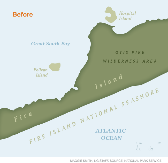
December 14, 2013, Stony Brook, NY— Superstorm Sandy, which made landfall in the New York metro area late October 2012, was the cause of three breaches through Fire Island at the eastern end of Great South Bay in the areas of Old Inlet, Smith Point and Moriches Inlet. The one with greatest potential impact was at Old Inlet, a narrow part of the island with a long history of breaches that fronts a portion of the mainland containing 13,000 homes collectively valued at $10 billion. How this breach will evolve and what impact it will have on Great South Bay communities are important questions facing coastal managers and nearby residents.
New York Sea Grant's coastal processes specialist Jay Tanski helped the National Park Service save millions of dollars by providing the team with research-based
information on impacts of new breaches and helped them
identify data needed to properly evaluate the situation.
Acting as a bridge between decision-makers and researchers, Tanski
quickly provided sound information to the National Park Service and other coastal managers when they needed it most. NPS used NYSG's information
to evaluate the condition of the breach and its impacts, and, after careful consideration, decided not to
undertake a major beach restoration effort immediately after the storm to close it, which would have cost approximately $6 million.
After working with this team, researchers approached NYSG for funds in order to study the breach – an initial investment which led
to further funds becoming available.
For more, see "NYSG Responds to Superstorm Sandy: Breach Assessment" and the related fact sheet, "Quick Response by New York Sea Grant Provides Information to Better Manage Hurricane Sandy Impacts" (pdf)).
NYSG’s Tanski is a co-author of a 2001 New York Sea Grant report: Impacts of Barrier Island Breaches on Selected Biological Resources of Great South Bay, New York (pdf)—an authoritative report on the biological impacts of breaches,
demonstrating both benefits and losses. He is also the author of Long Island’s Dynamic South Shore: A Primer on the Forces and Trends Shaping Our Coast (click here).
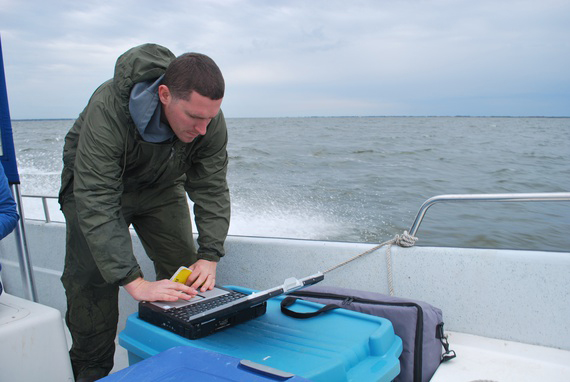
Ryan Wallace, a Stony Brook University doctoral student, analyzes water quality data in Long Island's Great South Bay in October 2013. Photo: Will James, The Atlantic, November 13, 2013 (pdf)
In the first quarter of this year, With Sea Grant funding, researchers Charlie Flagg and Roger Flood from the School of Marine and Atmospheric Sciences at Stony Brook University began gathering data to characterize the breach as it develops; its evolution will affect the tidal dynamics and the ecosystem of the eastern Great South Bay. Using sensors to measure sea level, temperature and salinity at Old Inlet and at nearby marinas and buoys in Great South Bay, the research team constantly monitored the breach.
“With real-time measurements of water levels, we will be able to alert managers if and when the breach undergoes a shift,” says Flagg. Reports following several November and December 2012 nor’easters indicate that the breach is remaining largely stable.
For a blog with Flagg/Flood's data documenting the evolution of the breach at Old Inlet from shortly after its inception during Superstorm Sandy, as well as some of Flagg's additional discussions with the media about the breach, see "Superstorm Sandy: One Year Later - Fire Island Breach Photo Journal Series."
On YouTube: National Geographic: Does Hurricane Sandy Have a Silver Lining (October 2013)
Last year, Hurricane Sandy split Fire Island, New York into two islands,
creating a new inlet to the bay behind it. As seen in this video clip
from National Geographic, New York Sea Grant-funded scientists say that
the breach actually helps clean the bay waters, and fishermen are seeing
positive changes.
Amid Superstorm Sandy's Havoc, A Win for Wildlife
A year after Hurricane Sandy smashed into the U.S. East Coast, some of the beaches and ocean areas are better for birds and marine life.
By Dan Vergano, National Geographic
October 29, 2013 — Hurricane Sandy's waves arrived at high tide, destroying 650,000 homes, flooding lower Manhattan, and inundating coastal wetlands. In a few places, however, the storm's fury appears to have wrought positive changes in the landscape.
In one Long Island bay, it turned the tide on decades of increasing pollution.
"Bellport Bay was as far as you could get from an inlet to the ocean, so it had the worst water quality," says Charles Flagg, a marine scientist at New York's Stony Brook University. "Now that's changed."
When Sandy made landfall on October 29, 2012, millions lost power and at least 147 people were killed. One year later, some communities are still rebuilding from the storm, the second-most costly hurricane to hit the U.S. since 1900, with damage of more than $50 billion.
Marshes, beaches, and wetlands also suffered. On Thursday, October 24, U.S. Secretary of the Interior Sally Jewell rolled out a $162 million plan to help 45 federal wildlife sites recover from the storm.
But amid the devastation caused by Sandy are a few places where the storm has improved wildlife habitat.
Better Bird Beaches
On the National Park Service's Rockaway beaches, part of New York's Gateway National Recreation Area, vegetation has been encroaching for years on nesting grounds for shorebirds, forcing them to nest closer to the surf, where flooding and high tides threaten the nests.
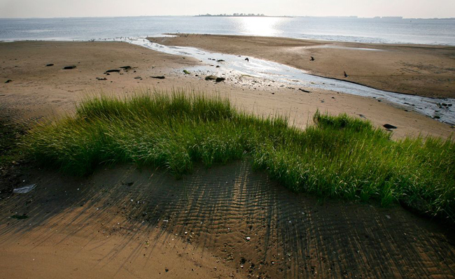
A strip of marsh is seen along Jamaica Bay's eastern shore off the Gateway National Recreation Area National Park in the Brooklyn section of New York City.
PHOTOGRAPH BY MIKE SEGAR, REUTERS/CORBIS
"Shorebirds need sand to build their nests, not too close to the water and not too close to vegetation," says Hanem Grace Abouelezz, a National Park Service biologist. "Our big concern is with the piping plover, which is a federal threatened species." (See NatGeo's "Hurricane Sandy Aftermath: What Happens to the Birds?")
On that October night last year, Superstorm Sandy ripped out 59 acres of beach grass and goldenrod on Rockaway's beaches, offering an almost 100 percent increase in shorebird nesting habitat. In 2012, NPS biologists reported that 54 percent of piping plover eggs were lost to flooding; in 2013, none were.
"Not only that, the storm scoured the sand and bared seashell deposits, which the birds prefer for nesting," says Abouelezz. The shells likely provide camouflage, confusing feral cats and other predators that hunt for shorebird eggs.
There are only 17 piping plover couples on the Rockaway beaches, so every egg counts. "They are very sensitive birds. They're just frail," Abouelezz says. "My house was knocked around pretty good by Sandy," she adds. "So, if I can see a bright side, anyone can."

A semipalmated sandpiper in Jamaica Bay National Refuge, Queens, New York City
PHOTOGRAPH BY ARTHUR MORRIS, CORBIS
Meadowlands Touchdown
Off the coast, Sandy's surge overtopped five-foot berms and floodgates along the Hackensack River. A Meadowlands Environmental Research Institute report found complete inundation of wetlands as well as parts of several nearby towns, which saw some residents fleeing their homes in boats and dead fish littering parks.
But one year later, the dousing seems to have benefited the 8,400-acre (34-square-kilometer) Meadowlands, the reed-covered wetlands west of New York City famed for its long history of abuse at the hands of polluters and developers. (See NatGeo's "Swamps of New Jersey: The Meadowlands")
"The storm actually moved a lot of debris out of the marshes that had been lodged there a long time," says Captain Bill Sheehan of Hackensack Riverkeeper, a private advocacy group for environmental cleanup of the region. The junk, lumber, trash, and reeds piled up five feet high in places along the New Jersey Turnpike, according to news reports.
"That really opened up a lot of the marshes for new growth," Sheehan says. Dirt and sand piled into some ponds that had been widening, he adds, filling them with sediment that served as a seedbed for fresh marsh grass stands.
"Nature moves things around," Sheehan says. "Wetlands are meant to handle those changes. Towns aren't."
Fire Island Surprise
Nowhere did Sandy move things around more dramatically than on Fire Island, a barrier beach between the Atlantic Ocean and Long Island's Great South Bay. Sandy blasted three breaches in the barrier islands along the south shore. Two of them were immediately filled in by the Army Corps of Engineers, as mandated by a Breach Contingency Plan put in place in 1997 by New York State's Department of Environmental Conservation (NYSDEC).
The third breach, across from the town of Bellport, was within the federally protected Fire Island National Seashore. Responding to the pleas of south shore residents, who blamed the breach for increased flooding in the months following the storm, politicians from Suffolk County Executive Steven Ballone to U.S. Senator Chuck Schumer called for that inlet to be closed as well.
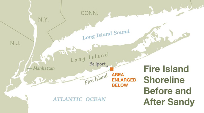
(pictured below) A before, after, and one-year later animation image of Fire Island and the breach that Superstorm Sandy created.
Environmentalists and fishermen protested, inspired by data compiled by Flagg showing that the increase in flooding in the Great South Bay was no greater than in other communities along the eastern seaboard. They were even more excited by the effect of an influx of clean ocean water into a bay that in the 1970s supplied three-quarters of the clams sold in the United States. That industry collapsed due to overfishing and groundwater polluted with sewage and lawn fertilizers seeping into the bay.
The NYSDEC decided to wait and see whether the inlet would close on its own. Over the summer it only increased in size, becoming a popular spot for fishermen catching fluke, striped bass, and bluefish that have also been taken in larger numbers farther into the bay. Seals and small sharks, rarely seen in Bellport Bay for close to a century, are now frequent visitors. Calls to close the inlet are fewer, and bay advocates have asked Senator Schumer to reconsider his position on having it filled in.
"You can see the bottom of the bay. It's clear," says Flagg, whose team had monitored the water for eight years prior to the storm. "That hasn't happened here in years."
Excess nutrients that had been trapped in the bay were diluted and flushed out by the influx of ocean water. As a result, "brown tides" caused by overgrowth of algae have not occurred in Bellport Bay this year, though they continue to plague other parts of the Great South Bay. Eel grass that was starving for sunlight in the murk may regrow, providing better habitat for juvenile clams. Already clammers are reporting "firmer clams" in the bay, Flagg says.
The last inlet that formed in this part of Fire Island, in 1760, stayed open for 60 years before closing naturally. How long the current inlet stays open, and whether it has any lasting effect on the health of Great South Bay, in anybody's guess.
"What we don't know are the long-term effects," says Flagg. "But what we can say objectively is that the water quality is improved."
Transcript for National Geographic Video: Does Hurricane Sandy Have a Silver Lining
TIM HERMUS, FISHMAN & OWNER, M& M CHARTERS: Before the inlet, there was kind of no life in Bellport Bay. And now, whatever we get, there will be some life.
Even if the inlet stays open, it's got its work cut out for it to keep up with what's been coming up the north side of the bay: people and population, and lawns and lawn fertilizers and swimming pools and that.
It can only help. Even just making a living, I left work in the water in Bellport in the early 80's and hopefully something will grow back and I can go back to it. It's kind of nice to get out of bed and be five minutes from your job.
CHARLES FLAGG, PHYSICAL OCEANOGRAPHER, STONY BROOK UNIVERSITY: Hurricane Sandy was an event that was hard to miss when you're living here. After the hurricane went by, the news spread that there was a breach.
SOT: "Clear." [Plane engine running]
Because of all the people who live here, and their septic systems and their fertilizing of the lawn and things of this sort in this part of Long Island in Suffolk County, there is a lot of nutrients that flow into the bay.
There was big build up over the last twenty, thirty years and it has impacted the bay by promoting algae blooms of various type. And the opening of the bay has increased the exchange of the ocean enormously, and the nutrients have gone down.
The last time there was an inlet in this immediate vicinity was in 1825. Big enough so during the Revolutionary War, British warships came through.
Right now this inlet can handle jet skis and light motorboats.
The old inlet is just a little bit to the West of this new inlet. If given enough time, the new inlet can probably migrate all the way there.
Like you look at that dock, and looks like it's almost in the ocean. That dock was the north side. It was a long walk up to the beach. And now you get to that dock and you're already in the ocean.
TIM HERMUS, FISHMAN & OWNER, M& M CHARTERS: It's crazy. I just looked around and said, "This has changed forever. It's never going to be the same."
JOHN DINARO, FISHERMAN & ARTIST, BELLPORT, NY: I was on the water ever since I was big enough to stick my feet in. It was a paradise.
SOT: [Boat engine starting] There were a lot of fishermen-they were oystermen, they were clammers. They had great big sloops they used to work from. And they made a very good living and supported a tremendous amount of families on the south shore of Long Island.
Now we have fresh seawater in the bay. It's increased the clarity of the bay. The shellfish are growing, and they're growing rapidly. And the quality of the meat is much better than it's been in the last twenty-five years.
CHARLES FLAGG, PHYSICAL OCEANOGRAPHER, STONY BROOK UNIVERSITY: Inlets and breaches, when left alone, will ultimately close. The numbers of people who stick around six weeks, six months or six decades. I mean, they have really no idea. In 200 years, another one will happen.