Public surveys set up to track flood damage along eastern Lake Ontario and the St. Lawrence River
— With reporting by Kara Lynn Dunn, publicist for New York Sea Grant's Great Lakes region; Content is also provided from the media sources cited below
To help Great Lakes-St. Lawrence River communities document the impact of record-breaking water levels, New York Sea Grant is asking residents, business owners and other lake stakeholders to complete an online survey.
The surveys—being conducted through rapid response funding provided to Cornell University Assistant Professor of Biological and Environmental Engineering Dr. Scott Steinschneider and Cornell University Professor of Natural Resources Dr. Richard C. Stedman—also include a request for participants to provide pictures that will be used to help illustrate what's happened.
"We're looking for occurrences of inundation, erosion, damage to natural and man-made shoreline protection features, disruption to travel and disruption to businesses," said Mary Austerman, New York Sea Grant's Coastal Community Development Specialist.
The surveys, which are open through August 31st, are available at www.nyseagrant.org/waterlevel2017. One survey is for property owners along or connected to New York’s Lake Ontario shoreline; the other is for the New York side of the St. Lawrence River. Individual addresses will not be identified in the results.
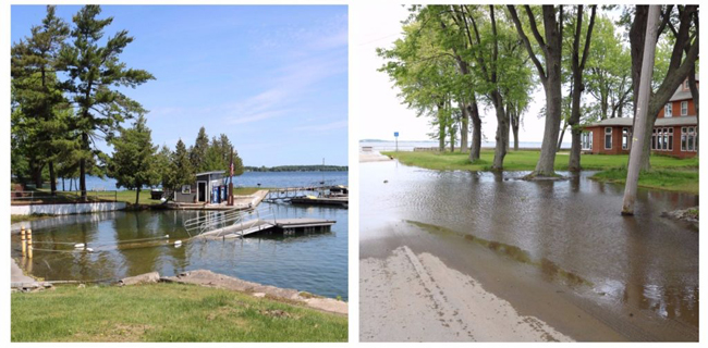
Left: High water in Clayton, New York, at Cedar Point State Park; Right: road flooding in Cape Vincent, New York. Credit: NYSG/Mary Austerman
The standardized data and responses will be used to document this year's impact and identify areas on the lake's southern and eastern shores that are most vulnerable to high water levels.
In the future, this data could be used to help affected communities leverage funding to become more adaptable to high water levels.
"It could also be used to formalize and validate an existing flood risk model that could inform community-level flood planning," said Austerman. "That would take additional funding—but a flood model could allow people to look at which parcels are impacted at different water levels, and could help inform local laws or codes going forward, and assist with other adaptive management strategies, such as elevating roads or raising the profile of the shoreline in certain areas so they are not as impacted by future high levels."
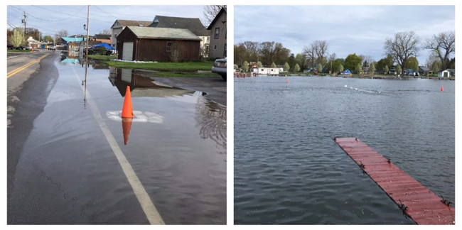
Left and right: High water in Sodus Bay, New York. Residents of this area along the southern shore of Lake Ontario pilot tested the survey. Credit: NYSG/Mary Austerman
Preliminary Findings
One of the key questions being addressed in the survey: Have waters from Lake Ontario or a connected water body inundated your dock, lawn, landscaping or the base of any outbuildings on your property during the 2017 high water event?
“A vast number of respondents so far have had some sort of (water) inundation,” said Steinschneider.
However, to the question of whether those waters had reached foundations of homes and businesses, a much smaller majority of initial respondents said yes, though Steinschneider added that it still is a significant number.
As for land lost to erosion, many respondents are saying they lost a substantial chunk of land to Lake Ontario.
As for businesses, a large number have reported “substantial impact” from the current high water levels, while those deriving rental income from properties also report a similar negative impact.
Further, preliminary results indicate that very few property owners carry flood insurance. Steinschneider said that’s understandable, because historically, there have been few years—save 1973—where levels approached current heights.
On YouTube: High Water Impact surveys set up to track flood damage (July 2017)
As NYSG's Mary Austerman explained on CNY Central in late July, waterfront property owners along Lake Ontario throughout Jefferson and Niagara Counties or along the St. Lawrence River are being asked to fill out electronic surveys this summer. People who used public spaces in the impacted areas are also invited to document changes, like beach erosion.
On YouTube: NY Sea Grant Hopes to Survey Flood Damage (May 2017)
Oftentimes when a major storm hits a community, it comes and goes. The damage is obvious, but people can soon begin the process of recovery.
But, as Northern NY's Spectrum News reporter Brian Dwyer reported on May 22, that isn't the case with Lake Ontario's flooding. We're still feeling the effects of weather conditions dating back to the fall, and water levels may not be back to normal until this coming fall.
That makes it very hard to track the financial damage and study the reasons why some infrastructure failed.
"This is the event without a storm, but it's an event of all of the storms. It's going to continue to have an impact. That makes it very uniquely different for people in that the water didn't rise and fall, and then we go back to business as usual and get things cleaned up," said New York Sea Grant's Recreation and Tourism Specialist Dave White.
On Air: Help document the summer of high water on Lake Ontario and St. Lawrence River
North Country Public Radio and local NPR Stations, including WBFO 88.7 FM (Buffalo/Niagara), WSKG (Ithaca 90.9 FM), WRVO FM (Oswego 89.9, Syracuse 90.3, Watertown 91.7, Clayton 89.3)
If you don't see the player above, it's because you're using a
non-Flash device (eg, iPhone or iPad). You can download the mp3 file by clicking here (mp3). It may take a few minutes to download, so please be patient.
"Some areas have been inundated for months and other areas are experiencing a significant amount of erosion," New York Sea Grant's Mary Austerman told North Country Public Radio. From Buffalo and Rochester all the way down the St. Lawrence to Ogdensburg, docks and boathouses have been underwater, lawns and basements flooded, town wastewater systems affected."
"I was getting contacted by property owners themselves, asking for a way to document some of the impacts that their properties were experiencing," said Austerman.
As of mid-August, more than 700 people have filled out online surveys along Lake Ontario, with another 70 logged by those along the St. Lawrence River. These surveys - available until Aug. 31st - are separate from state efforts to gauge property damages and help pay for repairs.
If you don't see the player above, it's because you're using a
non-Flash device (eg, iPhone or iPad). You can download the mp3 file by clicking here (mp3). It may take a few minutes to download, so please be patient.
The focus of these surveys is not on totaling monetary damages, said Austerman. New York State has set up hotlines for that and is offering millions of dollars to help pay for property damage. It is about recording what has happened and where.
"People forget quickly," she said. "This is just one way that we’re able to collect these reports in a standardized way - and we’re also collecting pictures so we’ll also have pictorial documentation of the event as well."
More Information
For more information, project leader Mary Austerman can be reached at 315-331-8415, mp357@cornell.edu or visit the New York Sea Grant Coastal Community Development Facebook page.
More Info: New York Sea Grant
New York Sea Grant (NYSG), a cooperative program of Cornell University
and the State University of New York, is one of 33 university-based
programs under the National Sea Grant College Program (NSGCP) of the
National Oceanic and Atmospheric Administration (NOAA). The NSGCP
engages this network of the nation’s top universities in conducting
scientific research, education, training and extension projects designed
to foster science-based decisions about the use and conservation of our
aquatic resources. Through its statewide network of integrated
services, NYSG has been promoting coastal vitality, environmental
sustainability, and citizen awareness about the State’s marine and Great
Lakes resources since 1971.
New York Sea Grant maintains Great Lakes offices at SUNY Buffalo, the
Wayne County Cooperative Extension office in Newark and at SUNY Oswego.
In the State's marine waters, NYSG has offices at Stony Brook University
and Stony Brook Manhattan, in the Hudson Valley through Cooperative
Extension in Kingston and at Brooklyn College.
For updates on Sea Grant activities: www.nyseagrant.org has RSS, Facebook, Twitter, and YouTube links. NYSG produces a monthly e-newsletter, "NOAA Sea Grant's Social Media Review," via its blog, www.nyseagrant.org/blog. Our program also offers a free e-list sign up via www.nyseagrant.org/coastlines for its flagship publication, NY Coastlines/Currents, which is published 1-2 times a year.