Update (October 27, 2011): Click on the images in the gallery below for photo documentation of the Oct 2011 King Tide.
Stony Brook, NY, September 29, 2011 - The Long Island Sound Study is participating in the King Tide campaign in an effort to help communities and individuals visualize the impacts of sea level rise. And we need your help!
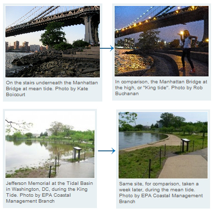
On October 26 and 27, our waters will be influenced by a "King Tide." A King Tide is the naturally occurring extreme high tide, which happens once or twice a year due to the alignment of both the sun and moon’s gravitational pull. During this time, there can be flooding not usually seen during daily high tides.
"The King Tide is a great way to get the public involved with documenting the naturally occurring extreme high tides," says New York Sea Grant's Long Island Sound Outreach Coordinator Larissa Graham. "It also provides an understanding of sea level rise."
As sea levels continue to rise due to climate change, this unusual flooding brought during the King Tide will become common as tides continue to rise and fall under an elevated sea level. Although not caused by sea level rise, the height of a King Tide gives us an idea of what the average high tide level will be in 20-30 years.
So, how can you help? By helping Long Island Sound Study "Capture the King Tide."
- Pick a site! Choose a site around Long Island Sound that is easy to access during high tide. (Please remember to exercise caution and do not go to areas where dangerous conditions exist!)
- Know the tides! Determine when the high tide will be for the daylight hours of Oct. 19 or 20 (for comparison) and the daylight hours of Oct. 26 or 27 (the King Tide!). You can do this by using the tide charts on the following Web sites: Connecticut tides and New York tides.
- Capture the King! Take photos of your site during HIGH TIDE and daylight hours of Oct. 19 or 20 (for comparison) and Oct. 26 or 27 (the King Tide!). IMPORTANT: Make sure the photos are taken from the same spot (or as close as possible) so we can be compare the water levels among the dates.
- Show us your stuff! Submit your photos, along with the time and date each photo was taken, to info@longislandsoundstudy.net or post them on Long Island Sound Study's Facebook page by Nov. 4. Selected photographs will be posted to the Long Island Sound Study’s Web site in early December.
For more information on tide predictions, visit
NOAA’s tides and currents Web site. To learn more about the King Tide visit the
Washington State Department of Ecology’s climate change Web site.
The "Capture the King Tide" campaign is It's being initiated by the US Environmental Protection Agency's Climate Ready Estuaries program. In addition to Long Island Sound, several other National Estuary Programs are taking part, including: The New York-New Jersey Harbor Estuary Program, Tampa Bay Estuary Program, Charlotte Harbor National Estuary Program, and the Sarasota Bay Estuary Program.
The Long Island Sound Study, conducted under the Environmental Protection Agency’s National Estuary Program, is a cooperative effort between the EPA and the states of Connecticut and New York to restore and protect the Sound and its ecosystems.
New York Sea Grant, now in its 40th year, is a statewide network of integrated research, education, and extension services promoting the coastal economic vitality, environmental sustainability and citizen awareness about the State's marine and Great Lakes resources. One of 32 university-based programs under the NOAA’s National Sea Grant College Program, NYSG is a cooperative program of the State University of New York and Cornell University.