New York Sea Grant has developed community assessment tools to help shoreline communities better prepare for flooding and other weather-related disasters.
— By Scott Willis, WAER News
Newark, NY, February 4, 2020 - Local governments now have a tool they can use to identify vulnerabilities to coastal flooding, like what’s been plaguing the shoreline of Lake Ontario. It’s called New York’s Great Lakes Coastal Resilience Index, and it was put together by New York Sea Grant.
Coastal Community Specialist Mary Austerman says the 44-page self-assessment tool helps municipalities look at different sectors.
"Infrastructure and facilities; transportation issues; community plans and agreements; business plans for the larger businesses, the types of businesses community members would rely in times of power failures or things like that."
It also includes groups and facilities like churches that might serve as gathering spaces or shelters in an emergency. The checklist goes beyond coastal flooding concerns; Austerman says it can also be used to assess vulnerabilities to other weather-related disasters such as wind and ice storms, and flooding from heavy precipitation. Now it’s up to communities to do the assessment. Austerman says she’s ready to schedule meetings.
If you don't see the player above, it's because you're using a
non-Flash device (eg, iPhone or iPad). You can download the mp3 file by clicking here (mp3). It may take a few minutes to download, so please be patient.
"I will go through their community plans and identify some of the things we look at, and then meet with the community and review each question within the coastal resilience index. The results are meant for communities to use as an internal tool to measure their progress as they improve resiliency."
Austerman says it’s not meant to be shared to rate communities against one another. The coastal resilience index is just the latest tool Austerman has worked on. Last summer, we told you about the inundation mapping tool, which provides models and views of areas down to specific properties that could experience flooding based on pre-determined water levels and elevation data.
"The communities are looking for an inexpensive and a relatively easy tools to use that can help them identify areas where they might need to spend more money to do more in-depth analysis. This tool and the inundation mapping tool can really help."
The Coastal Resilience Index self-assessment and related mapping tool can be found here.
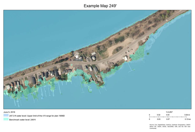
This is a sample map generated by the New York Sea Grant mapping tool. Note the difference is water level is less than two feet.
More Info: New York Sea Grant
New York Sea Grant (NYSG), a cooperative program of Cornell University
and the State University of New York (SUNY), is one of 34 university-based
programs under the National Oceanic and Atmospheric Administration’s
National Sea Grant College Program.
Since 1971, NYSG has represented a statewide network of integrated
research, education and extension services promoting coastal community
economic vitality, environmental sustainability and citizen awareness
and understanding about the State’s marine and Great Lakes resources.
Through NYSG’s efforts, the combined talents of university scientists
and extension specialists help develop and transfer science-based
information to many coastal user groups—businesses and industries,
federal, state and local government decision-makers and agency managers,
educators, the media and the interested public.
The program maintains Great Lakes offices at Cornell University, SUNY
Buffalo, SUNY Oswego and the Wayne County Cooperative Extension office
in Newark. In the State's marine waters, NYSG has offices at Stony Brook
University in Long Island, Brooklyn College and Cornell Cooperative
Extension in NYC and Kingston in the Hudson Valley.
For updates on Sea Grant activities: www.nyseagrant.org has RSS, Facebook, Twitter, and YouTube links. NYSG offers a free e-list sign up via www.nyseagrant.org/nycoastlines for its flagship publication, NY Coastlines/Currents, which is published quarterly. Our program also produces an occasional e-newsletter,"NOAA Sea Grant's Social Media Review," via its blog, www.nyseagrant.org/blog.