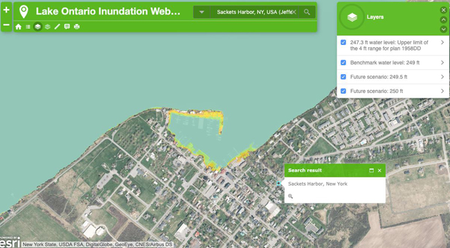
The mapping tool allows users to add layers of potential flood levels on Lake Ontario. Credit: Screenshot from NY Sea Grant app.
— Filed by: Emily Russell, Reporter/Producer in Plattsburgh for North Country Public Radio
Syracuse, NY, June 7, 2019 - People with property on the shores of Lake Ontario can now see how they might be impacted by flooding in the future. A new tool developed by a New York research program maps out potentially vulnerable areas along the lake.
Record high water levels on Lake Ontario are expected to crest in the next few weeks and then start to go down. Once that happens, people with lakefront property damaged from the flooding are left with a question—rebuild what was there before or rethink where to build next.
New York Sea Grant, a partnership between SUNY and Cornell University, may be able to help answer that question. With funding from the National Oceanic and Atmospheric Administration, NY Sea Grant researchers have developed a mapping tool for residents along Lake Ontario.
It’s like Google Maps, but for the future. Different layered colors on the map show different potential flooding scenarios.
If you type in Sackets Harbor in Jefferson County one future scenario shows the local marina and boat launch underwater. Add another foot of flooding to that and you’ve lost even more of the small town’s shoreline.
The different scenarios are not based on currently projected water levels. Rather, the Sea Grant says, they’re based on potential flood conditions and are offered for planning purposes only.
Governor Cuomo has warned that climate change could cause more frequent flooding on Lake Ontario and the St. Lawrence River. Flooding in 2017 cost the state about $100 million.
New York Sea Grant is offering a free 45-minute online training session on how to use the new mapping tool is scheduled for June 20 at 1 pm.
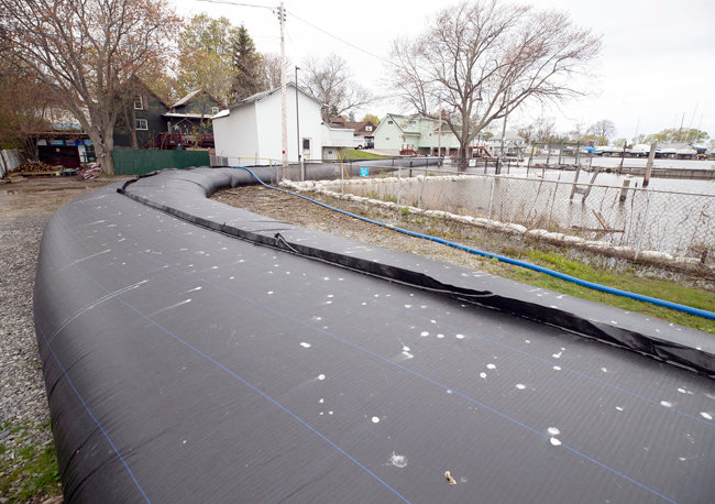
An aqua dam in place near Olcott, NY, to help prevent flooding from Lake Ontario, which has now exceeded its record high recorded in 2017. Credit: Office of Gov. Cuomo.
Related: Lake Ontario water levels exceed highest ever recorded
— Filed by: Fernando Narro, Reporter/Producer in Canton, NY for North Country Public Radio
Syracuse, NY, June 3, 2019 - Water levels in Lake Ontario are at their highest level ever. On Saturday, the lake went just above levels recorded in 2017, when major flooding affected communities along its shore and the St. Lawrence River.
And the lake is expected to keep rising in the coming days.
Keith Koralewski, with the International Lake Ontario-St. Lawrence River Board, said, “We are looking at under average conditions, that the lake could possibly be about an inch and a half to two inches higher overall than 2017.”
He says that peak could be reached within the next two weeks, because Lake Ontario is still receiving too much water from Lake Erie.
“All the great lakes have been experiencing a very wet weather pattern," Koralewski said, "and all are at record or near record highs at this time of year.”
But it’s not all bad news.
The board has increased outflows at Moses Saunders Dam near Massena to their highest levels this year.
Koralewski says that’s because the Ottawa River flows have gone down recently, easing flooding conditions near Montreal. That is allowing them to let more water flow downstream the St. Lawrence River.
The National Weather Service has issued a flood warning for all counties along Lake Ontario, from Niagara to Jefferson.
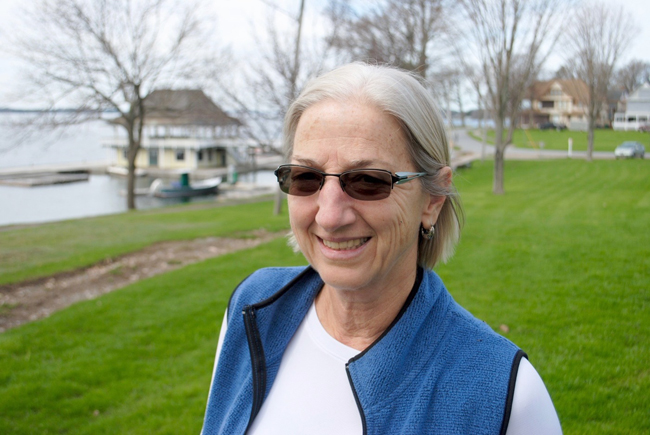
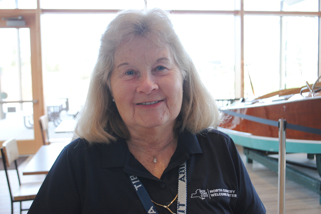
Holly Pelland operates the Thousand Islands Park marina and says she took a big financial hit after the 2017 flooding. Credit: Emily Russell.
Related: As water levels rise, will tourism dollars in the Thousand Islands drop?
— Filed by: Emily Russell, Reporter/Producer in Plattsburgh for North Country Public Radio
Syracuase, NY, May 10, 2019 - The Thousand Islands is a major tourist destination, but right now it's flooding. Water levels in the St. Lawrence River and Lake Ontario are higher than average and they’re expected to keep rising.
“Oh it’s wonderful," said year round resident Holly Pelland. "It’s like stepping back in time."
Like stepping back in time
Plenty of places along the St. Lawrence River cater to summer tourists, but the community of Thousand Islands Park boasts a special kind of charm.
Thousand Islands Park, or TI Park as it's known to locals, has the look of a really well maintained Victorian village - big houses with wrap around porches. There's a restored old hotel and a quaint little library in the middle of the big, green commons.
Summer is when TI Park really comes alive. “[There are] ice cream socials and little art shows and fishing derbys and sailing regattas," Pelland explained.
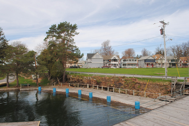
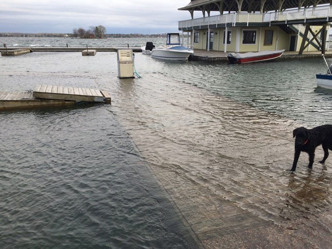
Some of the docks at the marina are already underwater this spring. Credit: Emily Russell.
Pelland runs the TI Park marina. Boaters can dock there, fill up on gas or just grab a scone at the cafe Pelland runs. She’s also got a business renting out bikes and kayaks.
Almost every part of what Pelland does relies on the St. Lawrence River. That’s why she’s been keeping a close eye on this spring’s rising water.
“We just watch it everyday because we’re not sure what’s going to happen," said Pelland. "We don’t want a repeat of two years ago.”
The Thousand Islands Park marina, where Pelland also operates a cafe from during the summer. Credit: Emily Russell.
Big financial hit from flooding
Two years ago - 2017 - was when Lake Ontario and St. Lawrence River surged over docks and up into boathouses and low-lying cottages. The water stayed high into August.
“I had no marina business," Pelland said. "My kayaks, I worked out of the back of my truck. It was a big financial hit.”
The 1000 Islands International Tourism Center surveyed more than 100 businesses in 2017 (pdf). It found more than 80% of them were hurt by the flooding. Some lost 40% of their business that year.
The Thousand Islands Park marina was boarded up for much of summer 2017. Credit: Holly Pelland.
Both tourists and locals had to get gas elsewhere during the summer of 2017. Credit: Holly Pelland.
It wasn’t just tourists who took their business elsewhere. Jim Brasser remembers what the marina looked like two years ago.
“The gas tank was underwater," Brasser explained. "The gas pump was underwater.”
Brasser has lived in Thousand Islands Park and boated on the St. Lawrence River for more than 30 years. When the TI Park marina was closed most of the season, Brasser went across the river and bought gas elsewhere.
Like shutting down the river
This kind of flooding is disruptive and it’s expensive. New York state alone spent nearly $100 million in clean up and recovery after 2017.
Brasser said Thousand Islands Park was actually lucky compared to some towns.
“TI Park sits up high, so in general it didn’t affect the cottage owners here, but it did affect their boating here.”
Barbara Peterson works at a NY tourism center near Thousand Islands Park. Credit: Emily Russell.
“It was like shutting down the river," said Barbara Peterson. "It was bad.”
Barbara Peterson works at the 1000 Islands International Tourism Center. Peterson said tour agencies, tour boat lines and big attractions like Boldt Castle were all hit by the high water.
It’s too early to know how this year’s high water will affect business in the area.
“We don’t have that many people yet - tourists - because school isn’t out yet," Peterson said. She is hopeful the flooding won't have as big of an effect on tourism as it did in 2017.
This weekend marks the start of the tourism season; the marina in TI Park opens, so does Boldt Castle.
Meanwhile water is expected to keep rising at least for another few weeks, though the National Weather Service says it does not expect flooding to be as bad as it was in 2017.
More Info: New York Sea Grant
New York Sea Grant (NYSG), a cooperative program of Cornell University
and the State University of New York (SUNY), is one of 33 university-based
programs under the National Oceanic and Atmospheric Administration’s
National Sea Grant College Program.
Since 1971, NYSG has represented a statewide network of integrated
research, education and extension services promoting coastal community
economic vitality, environmental sustainability and citizen awareness
and understanding about the State’s marine and Great Lakes resources.
Through NYSG’s efforts, the combined talents of university scientists
and extension specialists help develop and transfer science-based
information to many coastal user groups—businesses and industries,
federal, state and local government decision-makers and agency managers,
educators, the media and the interested public.
The program maintains Great Lakes offices at Cornell University, SUNY
Buffalo, SUNY Oswego and the Wayne County Cooperative Extension office
in Newark. In the State's marine waters, NYSG has offices at Stony Brook
University in Long Island, Brooklyn College and Cornell Cooperative
Extension in NYC and Kingston in the Hudson Valley.
For updates on Sea Grant activities: www.nyseagrant.org has RSS, Facebook, Twitter, and YouTube links. NYSG offers a free e-list sign up via www.nyseagrant.org/nycoastlines for its flagship publication, NY Coastlines/Currents, which is published quarterly. Our program also produces an occasional e-newsletter,"NOAA Sea Grant's Social Media Review," via its blog, www.nyseagrant.org/blog.