Contact:
Kathleen Fallon, Coastal Processes & Hazards Specialist, NYSG, E: kmf228@cornell.edu, P: (631) 632-8730
Hempstead, NY, November 16, 2018 - To mark 80 years after the “Long Island Express” hurricane hit the Northeast Coast, Hofstra University presented the symposium: Long Island Hurricanes on the 80th Anniversary of the 1938 Storm: Past, Present, and Future. Three panels explored the history of hurricanes on Long Island, unpacking the climatology and meteorology of past Long Island tropical cyclones, an assessment of current predictions of hazardous weather, and discussions on incorporating tropical cyclone risk into planning for Long Island’s sustainable future. Kathleen Fallon, NYSG’s Coastal Processes & Hazards Specialist, tabled and provided Sea Grant research on past hurricanes, and shared resources for hurricane preparedness.
Dr. Louis W. Uccellini, the National Oceanic and Atmospheric Administration's (NOAA) Assistant Administrator for Weather Services, and Director of the National Weather Service (NWS) gave the keynote address on the 1938 Hurricane. Uccellini is responsible for the day-to-day civilian weather operations for the United States, its territories, adjacent waters, and ocean areas.
After the address, New York Sea Grant interviewed Dr. Uccellini, who shared personal connections and professional insights on extreme weather forecasting after the 1938 storm:
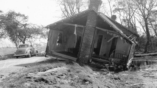
This house on Dune Road was washed inland, onto the Westhampton Country Club. Photo Credit: Westhampton Beach Historical Society. Credit: Newsday/Westhampton Beach Historical Society, Suffolk County Historical Society.
A Storm to Remember
On the South Shore of Long Island, the Shinnecock Inlet splits Westhampton Island from the eastern peninsula of Southampton. Opening Shinnecock Bay to the Atlantic Ocean, the inlet was created not by the power of dredging vessels, but by the tremendous forces of the 1938 “Long Island Express” Hurricane that ravaged Long Island and New England 80 years ago.
The storm was deadly. All told, across Long Island, Massachusetts, and Rhode Island, more than 600 people died, and at least 57,000 homes were damaged or destroyed. Over two billion trees across New York and New England were toppled, leveling old growth forests. It was the most devastating hurricane on record to strike the Northeast.
When he was growing up on Long Island, Louis Uccellini and his parents would visit their relatives and family friends’ duck farms on the east end of Long Island, and on the way cross over the Shinnecock Canal. During each crossing, his father regaled him with stories of the terrible storm. During September of 1938, his mother lived in Farmingdale, New York and his father lived in Bethpage, New York—two communities heavily impacted by the hurricane but spared from the most extreme damage.
“When they found out about the damage and the number of people killed, they were just stunned. So, whenever we went over the Shinnecock Canal, all we heard about was the ’38 storm,” Uccellini said.
In addition to the stories he heard, Dr. Uccellini also had his own experiences with northeastern snowstorms and several tropical storms.
“I was influenced by two things in respect to tropical weather. First, there were tropical storms that tracked across Long Island in the mid-1950s, which provided some of my first memories of weather. During Tropical Storm Carol, I was actually in upstate New York at a cabin with my family. We didn’t get any rain up there but I remember it because the ride home took almost a whole day. There were roads washed out, and that leaves an impression on a young child trying to get home,” said Uccellini.
The second tropical storm Uccellini remembers was Hurricane Donna. When Donna rolled over the United States’ eastern seaboard, the eye passed right over the Uccellini family home on Long Island. After the storm had passed, they found that each and every fruit on the pear trees in their backyard were ripped off of the tree.
“My father wouldn’t let us look out any window or door to see what was going on. So that certainly leaves an impression,” Uccellini said.
Dr. Uccellini would go on to earn his Bachelor of Science, Masters, and Ph.D. in Meteorology from the University of Wisconsin-Madison. His expertise lies in severe weather outbreaks, snowstorms, gravity waves, jet streaks, cyclones, and the use of satellite data in analysis and modeling applications. His connections to Long Island weather though, would drive him to research the 1938 hurricane for the Hofstra Symposium. During the six months he researched the storm for his keynote address, Dr. Uccellini learned several surprising details of the storm, especially those related to why there was no hurricane warning for Long Island and New England.
“I’ve always heard there was never a hurricane warning. So I was intrigued to learn more about the forecast process at the time, and exactly what happened.”
Uccellini dug into an account of the storm and all of its preluding drama, including the death of the Director of the Weather Bureau – known today as the National Weather Service – the week before the storm. And he emphasized the role played by Charles Pierce in the new analysis team that used new concepts of fronts and air masses and new upper air data to show why the storm moved north over Long Island and New England; all described in Lourdes B Aviles’ book, Taken by Storm 1938: A Social and Meteorological History of the Great New England Hurricane.
“Aviles’ book was perfect. I made sure to cite her throughout the presentation because I thought the audience should recognize the amount of work she did in pulling this story all together.”
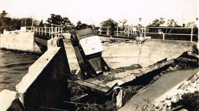
Quogue Bridge was damaged in the hurricane. Credit: Newsday/Westhampton Beach Historical Society.
A Turning Point for the Forecasting Community
The ’38 storm marked a very significant turning point for the Weather Bureau at the time, leading to significant changes in the forecasting process, many of which occurred under the leadership of Dr. Francis Reichelderfer, who presided over the Bureau from 1938 to 1963.
“The storm really ushered in the Reichelderfer era. He was someone who was forward leaning, embracing changes. I knew that, but I didn’t put this storm together in the sequence of events that led to his selections to lead the Weather Bureau until I went through this material. Changing a forecast process is a big deal because you have to deal with the entire culture. Not only do you have to train the workforce, but you have to change the culture of the workforce as well. The storm played a seminal role in accelerating those changes.”
World War II paused forecasting progress for non-military applications. But afterwards, the Reichelderfer era made great strides by way of numerical prediction and weather modeling.
“Reichelderfer very aggressively pursued numerical prediction which other weather agencies around the world avoided. By 1955, the US Weather Bureau was running models in real time; Sweden was the only other country that did that in that timeframe but then stopped. The idea of running an analysis system in real time, getting it into a computer in real time, running a model in real time, and getting the output out was absolutely remarkable.”
Uccellini cites the 1993 “Storm of the Century” as another influential weather event that shaped the future of forecasting. The 1993 storm “was the first time when we went out on a limb for extending a forecast of an extreme event, four to five days in advance, talking about a big storm before it even formed,” said Uccellini. That successful forecast served as validation that numerical models could give an accurate lead-time on extreme weather.
As a norm prior to ’93, the forecasting community would avoid forecasting record-breaking storms. Now, forecasters let numbers speak for themselves if data indicates a storm is going to be a “worst-ever” scenario. The accuracy of database forecasting has increased, and the ability to trust models that forecast storms outside normal scales or boundaries is extremely valuable for storm preparation, including the 2018 hurricane season.
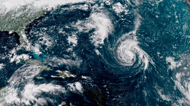
This enhanced satellite image shows Tropical Storm Florence, center, in the Atlantic Ocean in the afternoon of on Saturday, September 8, 2018. By the following morning the storm was upgraded to hurricane status. Credit: NOAA.
“We saw the manifestation of that in [Hurricane] Florence, that incredible forecast that hit the coast, stopped, went south and came back and around. And the National Hurricane Center captured the intensity forecast for Michael [two days before the storm], predicting a category-4 storm at landfall. The forecasters were skeptical about it for 48 hours, but the model stuck with it and we were able to predict the storm was making landfall as a major hurricane. I thought that was remarkable,” Uccellini said.
Into the Future, Beyond Forecasting
In addition to forecasting progress, the National Weather Service and other forecasting and emergency response agencies have also made great inroads with local communities, educating communities and building trust, so that when it’s time to evacuate, even the hardiest and hardened communities like Fire Island heed the call.
During Hurricane Sandy, Dr. Uccellini was working on general outreach to help communities prepare and evacuate. “We were impressed and amazed that [Suffolk County Emergency Management] was able to evacuate Fire Island. We all know there are hardened people out there who aren’t necessarily inclined to leave. I believe the reason this happened is because we worked hard and kept coming back to them, and kept coming back to them, and if we hadn’t gotten those people off the island there likely would have been many lives lost.”
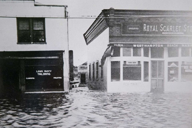
The 1938 Long Island Express created this flooding scene on Westhampton Beach's Main Street, between Husty Tailor Shop and Weixelbaum Market. The Category 3 hurricane on Sept. 21, 1938, took about 60 lives on Long Island, according to the National Hurricane Center. It also created the Shinnecock Inlet. Credit: Newsday/Westhampton Beach Historical Society, Suffolk County Historical Society.
The tremendous progress that the forecasting community has made provides dramatic contrast for what happened in the surprise hurricane of 1938. The south shore of Long Island and Providence, Rhode Island saw some of the most casualties, and were unwarned about the storm. In many ways, the 1938 storm serves as a model for what happens if a weather event with storm surge, high winds, and heavy rainfall is not forecasted.
“I have to believe that if we had this kind of a process in place for Providence, they would not have released workers into a growing storm surge that eventually reached ten feet, only to have to rescue them by throwing ropes out of windows to pull them up back into the buildings. I have to believe that the types of forecasts and warnings that we now provide days in advance would have prevented a large number of these deaths,” said Uccellini.
Eighty years later, forecasting, warning methods, and infrastructure have changed dramatically resulting in more prepared citizens and informed first responders. Forecasting has long been a dynamic process, and now, the biggest change is extending the impact of a forecast by going further to connect forecasts to decision makers at the federal, state, and local level.
“I think the key change that we’re implementing right now is that our job does not end with the provision of a forecast and a warning. Our job ends when we connect those forecasts and warnings to decision makers at the federal, state, and local level; and the organic level, to individuals, decisions are made by individuals and local communities, and by counties to evacuate or not. We have to make sure that we’re dealing with this whole spectrum of decision-making in a way that we map to those decision points in a way that people, organizations will make the right emissions. That’s the challenge that we’re attempting to work right now. That’s going to be a long haul but it’s essential,” said Uccellini.
“This is a very big advance that we’ve made over the last six years, and I believe we’re seeing the results during this hurricane season.”
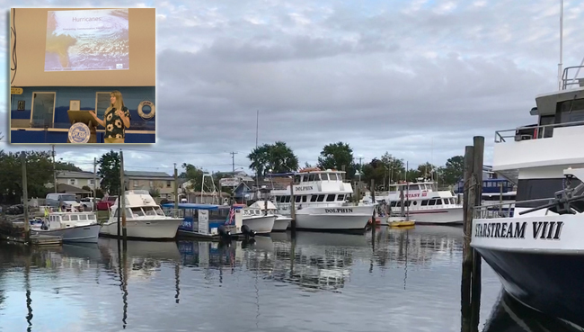
Although Superstorm Sandy hit Freeport's Nautical Mile hard in 2012, most businesses there have rebounded. (Inset) Kathleen Fallon, New York Sea Grant's Marine Coastal Processes and Hazards Specialist, welcomes the audience in Freeport at a late-September hurricane forum on forecasting, communication and preparedness. Credit: Ryan Strother.
New York Sea Grant’s Role in the Preparedness Network
Late this past summer, Kathleen Fallon, the Coastal Processes & Hazards Specialist for New York Sea Grant (NYSG), ran a series of Hurricane Forums, educating Long Islanders how hurricanes are forecasted, how to prepare for and stay safe during a storm, and how to keep pets safe.
According to Fallon, remembering the destruction of past storms can be a powerful tool to spur storm preparedness, but as time passes since the last storm the importance of outreach and engagement only grows. While there are still people trying to get back into their houses after Superstorm Sandy, there are also people who have since dealt with the impacts of the storm and may not remember the storm as vividly.
“I think it’s important for people on Long Island to always have a reminder of these things and to know that our island gets impacted by severe storms. The end of the hurricane season brings winter weather and a chance that we’re going to have to deal with flooding and power outages. Just because hurricane season is over doesn’t mean you should put away all of your emergency supplies.
“It’s a good idea to always have something prepared and ready,” said Fallon.
To commemorate the 80th anniversary of the 1938 hurricane, and look ahead to the future, an interdisciplinary symposium was held at Hofstra University in early October 2018 to recount the many impactful tropical cyclones that have affected Long Island over the years, assess our current forecasting and hazard communication techniques, and discuss future planning for resilience to these extreme events.
More Info: New York Sea Grant
New York Sea Grant (NYSG), a cooperative program of Cornell University
and the State University of New York (SUNY), is one of 33 university-based
programs under the National Oceanic and Atmospheric Administration’s
National Sea Grant College Program.
Since 1971, NYSG has represented a statewide network of integrated
research, education and extension services promoting coastal community
economic vitality, environmental sustainability and citizen awareness
and understanding about the State’s marine and Great Lakes resources.
Through NYSG’s efforts, the combined talents of university scientists
and extension specialists help develop and transfer science-based
information to many coastal user groups—businesses and industries,
federal, state and local government decision-makers and agency managers,
educators, the media and the interested public.
The program maintains Great Lakes offices at Cornell University, SUNY
Buffalo, SUNY Oswego and the Wayne County Cooperative Extension office
in Newark. In the State's marine waters, NYSG has offices at Stony Brook
University in Long Island, Brooklyn College and Cornell Cooperative
Extension in NYC and Kingston in the Hudson Valley.
For updates on Sea Grant activities: www.nyseagrant.org has RSS, Facebook, Twitter, and YouTube links. NYSG offers a free e-list sign up via www.nyseagrant.org/nycoastlines for its flagship publication, NY Coastlines/Currents, which is published quarterly. Our program also produces an occasional e-newsletter,"NOAA Sea Grant's Social Media Review," via its blog, www.nyseagrant.org/blog.