Contact:
Kathleen Fallon, Marine Coastal Processes and Hazards Specialist, NYSG, E: Kmf228@cornell.edu, P: 631-632-8730
New York, NY, November 7, 2018 – The dark blue paint on the bottom of the ocean mural surrounding the Operation SPLASH facility in Freeport, NY marks the nearly four feet of water that flooded the facility during Hurricane Sandy in 2012.
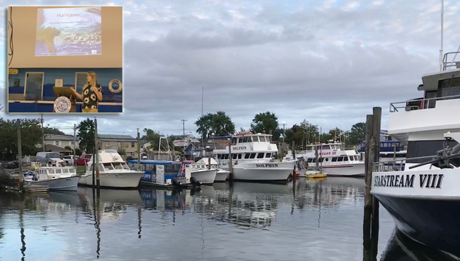
Although Superstorm Sandy hit Freeport's Nautical Mile hard in 2012, most businesses there have rebounded. (Inset)
Kathleen Fallon, New York Sea Grant's Marine Coastal Processes and
Hazards Specialist, welcomes the audience in Freeport at a
late-September hurricane forum on forecasting, communication and
preparedness. Credit: Ryan Strother.
Speaking to an audience seated below the historic flood level, Kathleen Fallon, NYSG’s Marine Coastal Processes and Hazards Specialist, shared information about forecasting, communications, and preparedness at the Hurricane Forum at the end of September. Fallon invited experts from the National Weather Service (NWS), Federal Emergency Management Agency (FEMA), and other local emergency managers to teach Long Islanders how hurricanes are forecasted, how to prepare for and stay safe during a storm, and even how to keep pets safe.
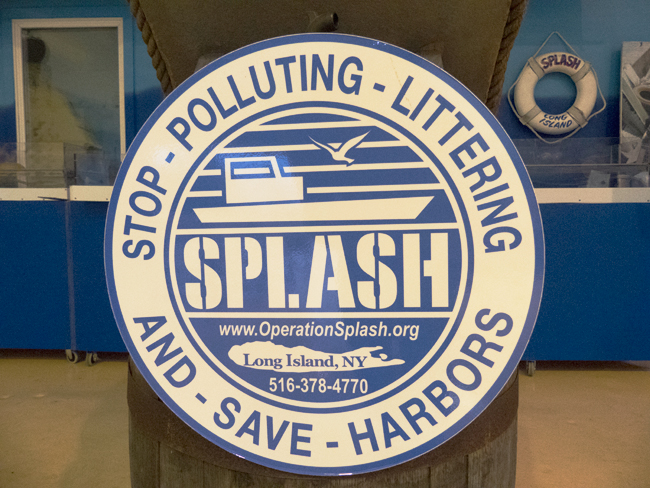
SPLASH boats patrol Long Island's local waterways. Over the past three decades, the organization's volunteers have rescued more than 2,000,000 pounds of trash, marine debris and navigational hazards from our bays, beaches and waterways. In addition, to help reduce the flow of toxins and trash into Long Island's bays, SPLASH collaborated on the funding and installation of more than 4,000 street storm drain inserts in Nassau County. More at www.operationsplash.net. Also see NYSG's "Marine Debris / Microplastics" news. Credit: Ryan Strother.
Fallon presented on the lasting impacts of Hurricane Sandy. The 2012 “Superstorm” caused 53 fatalities in New York State, and damaged, destroyed, or flooded over 100,000 homes. Though Sandy remains fresh on Long Islander’s minds, the 2017 season was one of the most active hurricane seasons on record. There were over 210 tropical cyclone related fatalities in the United States alone. Combined, Harvey, Irma, and other storms caused over $200 billion of damage to the United States.
Fallon explained that critical component of hurricane safety is effective evacuation. After Sandy, NYSG conducted a social science research program – NOAA Sea Grant’s Coastal Storm Awareness Program (CSAP), finding that people are more likely to heed mandatory evacuation orders than voluntary ones.
Pat Lloyd, lead forecaster with the NWS forecast office since 2006, explained that on average, the Tri-State area is impacted by a tropical storm about once every five years, and by a hurricane approximately once every 15-20 years. A typical storm’s track would be to the north northeast (NNE), tracing north about 30-35 miles per hour. This means that a hurricane off the coast of North Carolina can reach New York in 10 hours.
Lloyd explained that there are two general types of hurricane hazards: wind speed and storm surge.
For wind speed, there are differences between a tropical storm/hurricane watch/warning. During a watch phase, potentially affected people should prepare for the possibility of being exposed to hurricane force winds within 48 hours. After a watch is issued, you should secure your home, fill your gas tanks, and prepare an emergency kit—the earlier these steps can be done the better, as it was very difficult to get gas after Hurricane Sandy.
A warning, on the other hand, is the action phase. People in a tropical storm warning zone should expect tropical force winds (39-73 mph) within 36 hours. A hurricane watch means that hurricane force winds (74+ mph) will likely arrive within 36 hours.
Storm surge is dependent on factors separate from wind speed like landfall location, forward speed, angle of approach, intensity, and the size of the wind field, as well as tide levels. Storm surge watches and warnings started in 2013. A storm surge watch means there is a chance of life threatening inundation—meaning at least 3 feet of water above ground level from water moving inland within 48 hours. Once a watch is issued, the National Hurricane Center makes potential storm surge inundation maps. The maps depict a “reasonable worst case scenario” of storm surge.
Liz Botts, representing the pet disaster response team from Nassau County, presented on how to keep pets safe during a storm. Botts helped run the County’s Hurricane Shelter in the aftermath of Sandy, which she lived at to care for the animals for 4½ months. Botts explained that not every friend or family member who can provide you shelter during a severe weather event will be able to accommodate your pets, so pet owners should make a plan to be able to evacuate to a few different locations that allow pets.
A pet go-kit is also important to be prepared for a storm. A go-kit should include: copies of up-to-date vaccination records, copies of registration and licenses, as well as an updated picture of you and your pet. Also have phone numbers and addresses of your vet, friends and family, and regular boarding facility handy. This information is important to compile even if your pet has a microchip, because information on the chip may not be accessible during a widespread power or Internet outage.
Before you need to evacuate, be sure that you have a pet first-aid kit, seven day supply of up-to date medications for your pet, food, water, bowls, sanitation bags and supplies, as well as a collar with your name, pet’s name, and cell phone number on it.
Family and friends should be option number one to shelter your pets during an emergency. Animal shelters, though ready and willing to help, should be utilized as a last resort. During Sandy, some animals had to live in crates for several months, and not every animal is crate trained, which can cause problems for the shelter and the animals. Your boarding facility may work better than a shelter, because they will me familiar with your animal, and your pet may be less stressed in a familiar environment.

In the wake of a hurricane, FEMA says planning and preparing can make a big difference in safety and resiliency. The ability to quickly recover following a hurricane requires a focus on preparedness, advance planning, and knowing what to do in the event of a hurricane. For more, visit www.ready.gov/hurricanes. And for more what you can do to be ready, visit: www.weather.gov/safety/hurricane (NOAA's NWS) and nassaucountyspca.org/index.php/disaster-response (Nassau County Society for the Prevention of Cruelty to Animal's Pet Safe Program). Credit: Ryan Strother.
Eric Goldman from FEMA led an interactive discussion on hurricane preparedness. During this activity, the audience was presented with a hurricane scenario and then lead through several discussion questions, such as, “What is the flood risk for the area you live in?” and “Where do you keep copies of important documents?”. This walked participants through a much more personal understanding of storm preparedness.
More Info: New York Sea Grant
New York Sea Grant (NYSG), a cooperative program of Cornell University
and the State University of New York (SUNY), is one of 33 university-based
programs under the National Oceanic and Atmospheric Administration’s
National Sea Grant College Program.
Since 1971, NYSG has represented a statewide network of integrated
research, education and extension services promoting coastal community
economic vitality, environmental sustainability and citizen awareness
and understanding about the State’s marine and Great Lakes resources.
Through NYSG’s efforts, the combined talents of university scientists
and extension specialists help develop and transfer science-based
information to many coastal user groups—businesses and industries,
federal, state and local government decision-makers and agency managers,
educators, the media and the interested public.
The program maintains Great Lakes offices at Cornell University, SUNY
Buffalo, SUNY Oswego and the Wayne County Cooperative Extension office
in Newark. In the State's marine waters, NYSG has offices at Stony Brook
University in Long Island, Brooklyn College and Cornell Cooperative
Extension in NYC and Kingston in the Hudson Valley.
For updates on Sea Grant activities: www.nyseagrant.org has RSS, Facebook, Twitter, and YouTube links. NYSG offers a free e-list sign up via www.nyseagrant.org/nycoastlines for its flagship publication, NY Coastlines/Currents, which is published quarterly. Our program also produces an occasional e-newsletter,"NOAA Sea Grant's Social Media Review," via its blog, www.nyseagrant.org/blog.