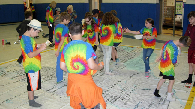
Children walk on the large map to understand the size and topography of New York state. Credit: Matt Savatgy/Cornell Cooperative Extension.
— By Ryan Strother, Freelance Publicist, NYSG
Published in Cornell Chronicle
Contacts
Nordica Holochuck, New York Sea Grant, Hudson Estuary Specialist, E: nch8@cornell.edu, P: (845) 340-3983
Susan B Hoskins, Cornell University Institute for Resource Information Sciences E: sbh1@cornell.edu
Kingston, NY, June 27, 2018 - Imagine being large enough to tiptoe across New York’s Adirondack Mountains or traverse the Erie Canal from Albany to Buffalo in just a few short steps. A giant traveling map gives students a novel way to do just that – by taking off their shoes and walking on a classroom-sized floor map of the Empire State.
Two copies of the map, which measures 17-by-21 feet, were gifted to the New York Geographic Alliance by National Geographic in 2016. The following year, New York Sea Grant partnered with the Cornell Institute for Resource Information Sciences and the New York Geographic Alliance to introduce the unique teaching resource to educators in New York’s Hudson River Valley region.
The map, which provides an opportunity for educators to make coastal connections for New Yorkers, raising awareness and improving coastal literacy, has appeared in more than a dozen schools and organizations this spring.
Susan Hoskins, senior extension associate in the College of Agriculture and Life Sciences, led workshops with teachers and classroom students, exemplifying how the giant map can engage classroom students. For example, students can be introduced to the concept of scale on a map by measuring the length of Long Island with their footsteps.
“The beautiful thing about working with this map is that specific activities written up in the map curriculum can be applied to any map in the United States. It helps kids learn the basics of map reading – scale resolution, symbology, orientation, all the things you need to know when you’re working with spatial data, whether it’s a giant map on the floor or a [Geographic Information System] rendering on your desktop,” said Hoskins.
Matt Savatgy, watershed youth educator for Cornell Cooperative Extension of Ulster County, brought the map to local schools to demonstrate the size and topography of New York.
“This map is an amazing hands-on tool,” said Phyllis Evans, a third-grade teacher at Woodstock Elementary in Woodstock, New York, who used the map with her students. “The children really enjoyed using their whole bodies to learn about the geography of New York.”
Leigh VanDeBogart, a fourth-grade teacher from Bennett Elementary in Boiceville, New York, added “This map is a great interactive way to view New York. It is also an excellent way for students to realize the size of the state and troubleshoot how to read a map without technology.”
Nordica Holochuck, New York Sea Grant’s Hudson estuary specialist, emphasized activities to engage and educate students about New York’s multitude of aquatic resources. In July 2017, New York Sea Grant held a workshop using the map with approximately 30 educators attending.
“New York has a multitude of diverse marine and freshwater coasts spread across the state. Our coastal waters are an economic and recreational treasure, and this map helps students grasp just how large, complicated and important our waters are to New York,” said Holochuck.
More Info: New York Sea Grant
New York Sea Grant (NYSG), a cooperative program of Cornell University
and the State University of New York (SUNY), is one of 33 university-based
programs under the National Oceanic and Atmospheric Administration’s
National Sea Grant College Program.
Since 1971, NYSG has represented a statewide network of integrated
research, education and extension services promoting coastal community
economic vitality, environmental sustainability and citizen awareness
and understanding about the State’s marine and Great Lakes resources.
Through NYSG’s efforts, the combined talents of university scientists
and extension specialists help develop and transfer science-based
information to many coastal user groups—businesses and industries,
federal, state and local government decision-makers and agency managers,
educators, the media and the interested public.
The program maintains Great Lakes offices at Cornell University, SUNY
Buffalo, SUNY Oswego and the Wayne County Cooperative Extension office
in Newark. In the State's marine waters, NYSG has offices at Stony Brook
University in Long Island, Brooklyn College and Cornell Cooperative
Extension in NYC and Kingston in the Hudson Valley.
For updates on Sea Grant activities: www.nyseagrant.org has RSS, Facebook, Twitter, and YouTube links. NYSG offers a free e-list sign up via www.nyseagrant.org/nycoastlines for its flagship publication, NY Coastlines/Currents, which is published quarterly. Our program also produces an occasional e-newsletter,"NOAA Sea Grant's Social Media Review," via its blog, www.nyseagrant.org/blog.